Open Access is an initiative that aims to make scientific research freely available to all. To date our community has made over 100 million downloads. It’s based on principles of collaboration, unobstructed discovery, and, most importantly, scientific progression. As PhD students, we found it difficult to access the research we needed, so we decided to create a new Open Access publisher that levels the playing field for scientists across the world. How? By making research easy to access, and puts the academic needs of the researchers before the business interests of publishers.
We are a community of more than 103,000 authors and editors from 3,291 institutions spanning 160 countries, including Nobel Prize winners and some of the world’s most-cited researchers. Publishing on IntechOpen allows authors to earn citations and find new collaborators, meaning more people see your work not only from your own field of study, but from other related fields too.
To purchase hard copies of this book, please contact the representative in India:
CBS Publishers & Distributors Pvt. Ltd.
www.cbspd.com
|
customercare@cbspd.com
Geodetic data processing involves using mathematical and computational techniques to analyze and interpret geospatial data about the Earth’s surface and the objects and features that exist on it. This data is collected through satellite imagery, aerial photography, and surveying instruments such as total stations and GPS receivers. The applications of geodetic data processing are diverse and include land surveying, mapping, navigation, environmental monitoring, and disaster management. It is crucial to understand and manage the Earth’s resources and address global challenges such as climate change, natural disasters, and urbanization. In recent years, the information technology industry has undergone a considerable transformation that has significantly impacted the development of various disciplines. Intelligent systems, powerful tools for understanding and solving complex engineering issues, have become increasingly important in this context. Soft computing techniques, including artificial neural networks, fuzzy logic, and evolutionary algorithms, are used more frequently in geodetic data processing due to their ability to handle complex, imprecise, and uncertain data. This study discusses using soft computing techniques in geodetic data processing and examines the challenges and future directions in using soft computing techniques in geodetic data processing.
Faculty of Civil Engineering, Damascus University, Syria
*Address all correspondence to: maan.habib@gmail.com
1. Introduction
Geodetic data processing plays a pivotal role in our ability to understand, manage, and preserve the Earth’s resources. As the foundation of modern geospatial applications, it allows us to accurately represent and analyze the Earth’s surface and the objects and features that exist on it. The data collected through satellite imagery, aerial photography, and surveying instruments is vital for various applications, including land surveying, mapping, navigation, environmental monitoring, and disaster management. The need for efficient and reliable geodetic data processing methods has grown significantly due to the increasing global population, rapid urbanization, and the urgency to address climate change. Accurate geodetic data is essential for informed decision-making as it helps in planning sustainable urban growth, assessing the impacts of climate change, and mitigating the effects of natural disasters.
Processing geodetic data presents several challenges, arising from the vast amounts of data collected from various sources, the inherent uncertainties and complexities associated with geospatial data, and the need for timely and accurate analysis. Traditional geodetic data processing methods rely on deterministic mathematical models and rigorous computational techniques to make sense of the data. In contrast, these methods have been effective in many cases, and they often struggle to handle the uncertainties and complexities in geodetic data. Some of the critical challenges in processing geodetic data include the following [1, 2]:
Data volume: The increasing availability of high-resolution satellite imagery and other geospatial data sources has led to significant growth in the volume of data that must be processed, stored, and analyzed.
Data quality: Geodetic data can be affected by various sources of error, including measurement errors, sensor limitations, and atmospheric disturbances. These errors introduce uncertainty and imprecision in the data, making it challenging to obtain accurate and reliable results.
Data integration: Geodetic data is often collected from multiple sources and in various formats, requiring effective data integration and fusion techniques to combine information and generate a coherent representation of the Earth’s surface.
Scalability: With the growing demand for geospatial information, there is a need for scalable processing methods that can efficiently handle large-scale datasets and provide timely results.
In response to these challenges, researchers have begun to explore alternative approaches to geodetic data processing, with soft computing techniques emerging as a promising option. Soft computing is an interdisciplinary field that encompasses several computational methodologies, including artificial neural networks (ANNs) [3, 4, 5], fuzzy logic, and evolutionary algorithms (EAs). These techniques are characterized by their ability to handle imprecise, uncertain, and incomplete information, making them well-suited for addressing the challenges associated with geodetic data processing. Soft computing techniques have demonstrated their potential in various geodetic data processing tasks such as satellite image classification [6], terrain modeling [7], and geoid determination [8, 9]. They are particularly effective in pattern recognition, learning from data, and optimizing complex problems. The flexibility and adaptability of soft computing techniques have made them an attractive alternative to traditional geodetic data processing methods, often leading to improved performance and more accurate results [10, 11]. In addition, soft computing techniques are often employed in conjunction with traditional geodetic data processing methods, resulting in hybrid approaches that leverage the strengths of both paradigms [12]. This combination allows for more robust and versatile solutions capable of tackling diverse challenges in the geodetic data processing.
Accordingly, the emergence of soft computing techniques in geodetic data processing offers a promising avenue for addressing the complexities and uncertainties inherent in geospatial data [13]. As researchers continue to explore and refine these techniques, it is expected to see significant advancements in understanding and managing the planet’s resources and addressing pressing global challenges such as climate change, natural disasters, and urbanization. By integrating soft computing techniques with traditional geodetic data processing methods, it can develop innovative solutions that increase the accuracy and efficiency of geodetic data processing tasks and unlock new possibilities for research and application in geospatial information. As soft computing techniques continue to gain traction in the geodetic data processing community, scholars must stay abreast of the latest developments in the field. Collaborative efforts between geodesy, remote sensing, computer science, and artificial intelligence experts will drive further innovation and progress in applying soft computing techniques to geodetic data processing. The ongoing evolution of soft computing techniques and the increasing availability of high-resolution geospatial data presents an exciting opportunity for researchers to explore new methods, tools, and applications in the geodetic data processing. As we continue to push the boundaries of what is possible with geospatial data, the integration of soft computing techniques and traditional geodetic data processing methods promises to play a pivotal role in shaping the future of the field.
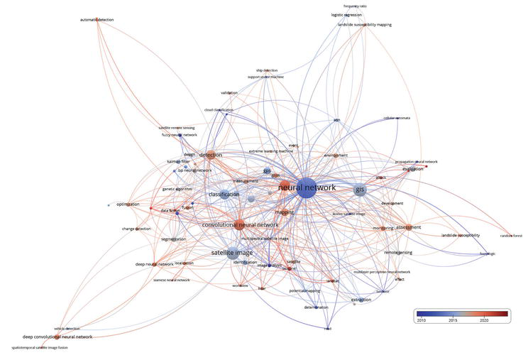
Over the past two decades, a substantial amount of research has been conducted in the field of geodetic data processing using soft computing techniques. This bibliographic review aims to provide a comprehensive overview of the most relevant literature in this area, focusing on using artificial neural networks, fuzzy logic, and evolutionary algorithms. The Web of Science Core Collection database was used to gather the data, and VOSviewer software was employed to generate the co-words maps (Figure 1). Presents a co-words map, revealing the prevalence of specific soft computing techniques in geodetic data processing research over the years. The map depicts that most studies published in the early 2010s primarily focused on neural networks, reflecting the growing interest in this technique. The color scale suggests that research on other machine learning methods, such as random forest, has gained momentum in recent years, indicating diversification of soft computing techniques applied in the field.
Figure 1.
Co-words map from the co-occurrence frequency of the primary keyword in papers’ titles (The color scale represent years for which the majority of the paper were published).
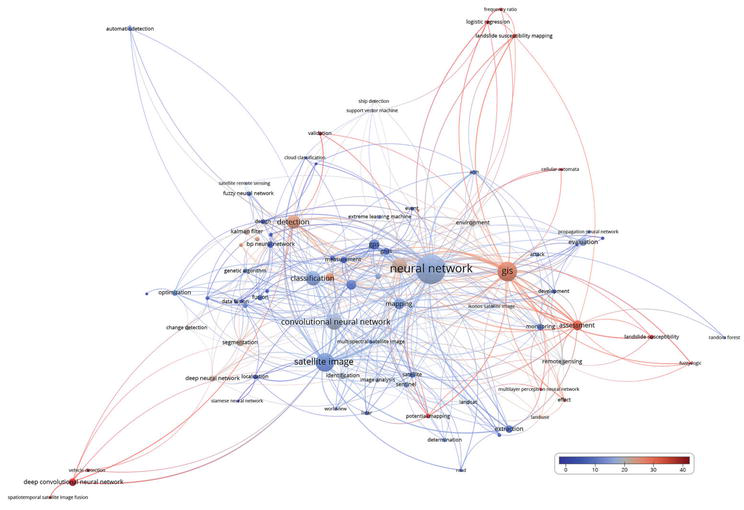
Figure 2 provides another co-words map, highlighting the average number of citations related to specific soft computing techniques per paper. It shows that most citations are attributed to papers focused on deep convolutional neural networks. This demonstrates deep learning approaches’ significant impact and recognition in the geodetic data processing. The high citation rate for deep convolutional neural networks-related papers suggests that these techniques have successfully addressed complex geodetic data processing tasks, leading to increased interest and adoption by researchers.
Figure 2.
Co-words map from the co-occurrence frequency of the primary keyword in papers’ titles (The color scale represents the average number of citations for each of the papers published).
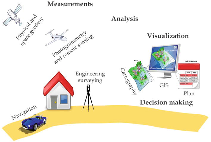
Geodetic data processing involves the collection, analysis, and interpretation of data about the Earth’s surface and the objects and features that exist on it. This data is collected through various methods, including satellite imagery, aerial photography, and surveying instruments such as total stations and GPS receivers. Once collected, the data is processed and analyzed to extract meaningful information about the Earth’s surface, which can be used in various applications, as depicted in Figure 3.
Figure 3.
Geodetic data processing.
3.1 Data collection methods
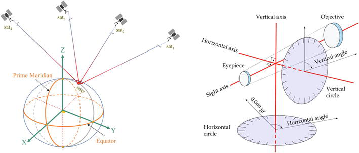
This section discusses various data collection methods for geographical analysis (Figure 4). They explore satellite imagery, aerial photography, and surveying instruments as essential tools for gathering accurate and reliable information about the Earth’s surface [14, 15, 16, 17].
Figure 4.
Satellite and terrestrial geodetic data collection methods
Satellite imagery is a primary source of geodetic data and involves capturing images of the Earth’s surface using remote sensing satellites. These images provide valuable information about the Earth’s topography, land use, and vegetation patterns. Satellite imagery can be categorized based on spatial, spectral, and temporal resolutions. High-resolution satellite images, such as those provided by the Landsat and Sentinel programs, allow for identifying small features and more detailed analysis. In contrast, lower-resolution images, such as those from MODIS, are helpful for large-scale environmental monitoring and global change studies.
Aerial photography involves capturing images of the Earth’s surface from aircraft, balloons, or drones. Aerial photographs have been used for decades to collect geodetic data and can provide higher-resolution imagery compared to satellite imagery, allowing for a more detailed analysis of local features. Aerial photography can be either vertical, where the camera is oriented directly towards the ground, or oblique, where the camera is angled, providing a perspective view of the landscape. Advances in technology have led to the development of digital aerial cameras and photogrammetric techniques, which enable the extraction of accurate 3D information from overlapping aerial photographs.
Surveying instruments are essential tools for collecting geodetic data on the ground. Traditional instruments, such as total stations, measure angles and distances between points on the Earth’s surface, allowing for the accurate determination of positions, elevations, and other spatial information. The global positioning system (GPS) and other global navigation satellite systems (GNSS) have revolutionized geodetic data collection by providing precise positioning information using signals from orbiting satellites. Other surveying instruments, such as LiDAR (Light Detection and Ranging) and ground-penetrating radar (GPR), enable the collection of high-resolution topographic and subsurface data.
3.2 Applications of geodetic data processing
This section presents the diverse applications of geodetic data processing (Figure 5). As a critical component in land surveying, mapping, and navigation, it provides valuable insights for effective decision-making [18, 19]. Additionally, its role in environmental monitoring and disaster management is highlighted, emphasizing its potential to facilitate sustainable development and enhance public safety [20, 21, 22].
Figure 5.
Map production.
Land surveying is a fundamental application of geodetic data processing and involves measuring and mapping the Earth’s surface to establish property boundaries, rights-of-way, and other land-related features. Geodetic data processing techniques derive accurate positional information, compute areas and volumes, and generate topographic maps and digital terrain models (DTMs) essential for land use planning, resource management, and property rights administration.
Mapping is a core application of geodetic data processing and includes creating various types of maps such as topographic, thematic, and cadastral maps. Geodetic data processing techniques transform raw geospatial data into useful map products that depict the spatial distribution of features such as terrain, land use, and infrastructure. Advances in geodetic data processing have led to the development of geographic information systems (GIS), allowing spatial data to be stored, analyzed, and visualized in digital form.
Navigation is an essential application of geodetic data processing, particularly in the context of GPS and other GNSS. Geodetic data processing techniques are employed to determine precise positions and velocities, compute distances and directions, and generate land, air, and sea navigation routes. The development of real-time kinematic (RTK) GPS and other high-precision positioning techniques has greatly improved the accuracy and reliability of navigation systems, with wide-ranging applications in transportation, agriculture, and other industries.
Environmental monitoring is a crucial application of geodetic data processing that involves observing and analyzing changes in the Earth’s environment over time. Geodetic data processing techniques are employed to process satellite imagery, aerial photographs, and other geospatial data to assess land cover changes, deforestation, desertification, urbanization, and other environmental phenomena. Remote sensing and GIS technologies enable large-scale monitoring and analysis of environmental parameters, such as vegetation health, soil moisture, and water quality, essential for understanding the impacts of climate change and human activities on the Earth’s ecosystems and resources.
Disaster management is a critical application of geodetic data processing, which plays a vital role in the assessment, mitigation, and recovery phases of natural and human-induced disasters. Geodetic data processing techniques can be utilized to analyze and model hazard scenarios, such as earthquakes, landslides, floods, and wildfires, and to generate risk and vulnerability maps that inform emergency planning and response efforts. In the aftermath of disasters, satellite imagery, aerial photography, and other geospatial data can be rapidly processed to assess the extent of damage, prioritize recovery efforts, and monitor the progress of reconstruction activities.
However, geodetic data processing is essential for various applications, from land surveying and mapping to navigation, environmental monitoring, and disaster management. The various data collection methods, including satellite imagery, aerial photography, and surveying instruments, provide diverse and complementary sources of geospatial information that can be processed and analyzed using advanced techniques and technologies. As the field of geodetic data processing continues to evolve, the development and application of innovative approaches, such as soft computing techniques, will be crucial for addressing the complex challenges associated with collecting, analyzing, and interpreting geodetic data.
In recent years, the employment of soft computing techniques within geodetic data processing has garnered substantial attention as these methods have demonstrated enhanced accuracy and efficacy in addressing intricate problems [23, 24, 25]. This section delves into various soft computing techniques utilized in the geodetic data processing. They explore the applications of ANNs, fuzzy logic, EAs, and others, shedding light on their distinct advantages [26, 27, 28, 29]. In addition, they discuss hybrid approaches that synergistically combine soft computing techniques with traditional methods, enhancing geodetic data analysis’s overall efficiency and accuracy. Table 1 lists a succinct overview of prior investigations.
Applied computational intelligence in optical remote sensing image processing.
Table 1.
Summary of soft computing techniques in the geodetic data processing.
4.1 Artificial neural networks
Artificial neural networks have been widely applied in various aspects of geodetic data processing due to their ability to model complex relationships, learn from data, and generalize from previous experiences. Some notable applications include:
Satellite image classification: ANNs have been employed to classify multispectral and hyperspectral satellite imagery. Compared to traditional classification methods, they have demonstrated improved accuracy in identifying land cover types, urban features, and other geospatial objects.
Terrain modeling: ANNs have been used for digital elevation model (DEM) generation and analysis. They can interpolate elevation data from sparse samples, detect terrain features, and model complex surface processes such as erosion and deposition.
Geoid determination: ANNs have been applied for geoid modeling, which is crucial for accurate height determination and geodetic positioning. They can effectively model the complex and nonlinear relationships between gravity anomalies, topography, and geoid undulations.
4.2 Fuzzy logic
Fuzzy logic has been used in geodetic data processing to address the inherent uncertainties and imprecisions in geospatial data. Some of the critical applications involve:
Data fusion: Fuzzy logic can be applied to fuse geospatial data from multiple sources such as satellite imagery, aerial photography, and ground-based measurements. It allows for integrating heterogeneous data while accounting for inconsistencies and uncertainties.
Geospatial analysis: Fuzzy logic enables the modeling of vague and imprecise spatial relationships such as proximity, similarity, and connectivity. It has been used in various geospatial analyses, including site selection, land use planning, and environmental impact assessment.
Uncertainty modeling: Fuzzy logic can be utilized to represent and propagate uncertainties in geodetic data processing tasks such as coordinate transformation, network adjustment, and error analysis.
4.3 Evolutionary algorithms
Evolutionary algorithms have successfully solved optimization problems in geodetic data processing thanks to their ability to search through large and complex solution spaces. Some noteworthy applications include:
Parameter estimation: EAs have been used for estimating model parameters in various geodetic applications such as satellite orbit determination, geoid modeling, and crustal deformation analysis.
Feature selection: EAs can be employed to select optimal subsets of features for geospatial data classification and analysis, resulting in reduced dimensionality and improved performance.
Model optimization: EAs have been utilized for optimizing geodetic models and algorithms such as geodetic network adjustment, datum transformation, and spatial interpolation.
4.4 Hybrid approaches
Hybrid approaches, which integrate soft computing techniques with traditional geodetic data processing methods, have gained popularity due to their ability to capitalize on the strengths of both approaches [13, 44, 45]. Some notable applications include:
Image classification: Combining ANNs and fuzzy logic has been shown to improve the classification of remote sensing images [46]. Integrating these methods can lead to more accurate and reliable results, as Mellit and Kalogirou [47] and Scott et al. [48] demonstrated.
Land cover classification: Mather and Tso [49] developed a hybrid approach using genetic algorithms and ANNs for land cover classification. By incorporating the optimization capabilities of EAs with the learning abilities of ANNs, their method achieved improved performance compared to individual techniques. Rabelo et al. [50] presented a hybrid approach that combines neural networks, simulation, genetic algorithms, and machine learning to address real-time sequencing and scheduling problems. The study, included in the Practical Handbook of Genetic Algorithms, highlighted the potential of integrating these advanced techniques for improved performance and adaptability when dealing with complex scheduling issues in dynamic environments.
Geospatial analysis: Mallick et al. [51] integrated fuzzy logic with a traditional GIS-based multi-criteria decision analysis method for landslide susceptibility mapping. Nzotcha et al. [52] proposed an integrated multi-criteria decision-making methodology for selecting optimal sites for pumped hydro-energy storage plants from a sustainable development perspective. The study combined various decision-making techniques, such as the analytic hierarchy process (AHP), fuzzy logic, and GIS-based spatial analysis, to evaluate potential locations. The integrated approach facilitated a comprehensive evaluation of environmental, social, and economic factors, leading to more sustainable and informed decision-making in site selection.
Spatial interpolation: Using MODIS satellite data, Kartal and Sekertekin [53] developed novel hybrid models for predicting land surface temperature (LST). Their approach combined spatial interpolation techniques of geodetic data with deep learning models, resulting in more accurate LST predictions. Jiang et al. [54] investigated the quantitative soil salinity assessment using multisource remote sensing data. They employed a hybrid approach combining support vector machines (SVMs) and ANNs to improve the accuracy of soil salinity estimation. These studies highlighted the potential of integrating advanced computational methods with traditional geospatial techniques to enhance the accuracy and reliability of environmental predictions and assessments.
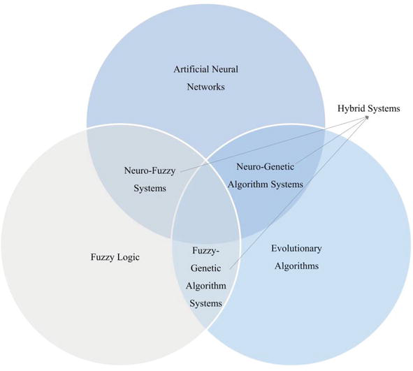
These examples illustrate the potential benefits of integrating soft computing techniques (Figure 6) with traditional geodetic data processing methods, enabling more robust, accurate, and efficient solutions for various geospatial tasks. Combining these approaches can help address the complex challenges associated with geodetic data processing, paving the way for further advancements and innovations in the field.
5. Advantages and limitations of soft computing techniques
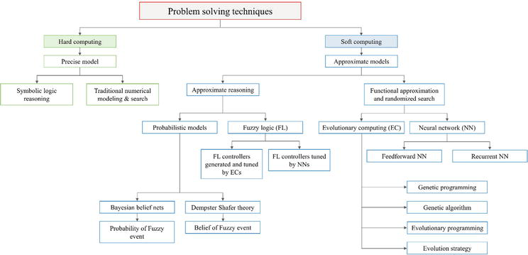
Hard and soft computing techniques (Figure 7) are two distinct approaches to problem-solving in computer science and artificial intelligence. Both methods have advantages and applications, and often, a combination of the two is employed to find optimal solutions [55, 56, 57]. Hard or conventional computing is rooted in mathematical logic, precise algorithms, and deterministic models. This approach is characterized by its rigidity and strict adherence to predefined rules and instructions. It requires a well-defined problem, and its solutions are exact and reliable. In contrast, soft computing is a more flexible and adaptive approach that focuses on imprecision and uncertainty in problem-solving. Unlike hard computing, soft computing tolerates imprecise data and partial truth, making it suitable for handling complex, real-world problems [58].
Figure 7.
Hard and soft computing techniques.
The emergence of soft computing techniques has brought a new dimension to geodetic data processing, allowing for handling complex, imprecise, and uncertain data. These techniques have demonstrated their effectiveness in various geodetic data processing tasks. However, despite their potential, advantages and limitations are associated with using soft computing techniques. This section explores the benefits and challenges of using soft computing techniques in geodetic data processing, providing insight into the strengths and weaknesses of each approach [59, 60, 61, 62, 63]. By understanding these advantages and limitations, researchers can make informed decisions when selecting and applying soft computing techniques to geodetic data processing tasks if they comprehend these advantages and limitations.
5.1 Advantages
One of the primary advantages of soft computing techniques is their ability to handle imprecise, uncertain, and incomplete data. This is particularly important in geodetic data processing, as geospatial data often contains errors, uncertainties, and gaps due to sensor noise, measurement inaccuracies, and data loss during transmission. Soft computing techniques, such as artificial neural networks, fuzzy logic, and evolutionary algorithms, can effectively deal with these challenges by modeling and processing data flexibly and tolerantly. For example, fuzzy logic allows for representing and manipulating uncertain and imprecise data by extending traditional binary logic to incorporate the concept of partial truth. This enables the development of models and algorithms to better account for the inherent ambiguities and uncertainties in geodetic data. Similarly, artificial neural networks can learn and adapt to noisy or incomplete data by adjusting their internal weights and biases through iterative training, resulting in more robust and accurate models.
Soft computing techniques are known for their adaptability and flexibility, making them well-suited for addressing the diverse and dynamic challenges associated with geodetic data processing. Adjusting their parameters, architectures, and training strategies can easily be tailored to specific tasks and applications. In addition, soft computing techniques can often learn and adapt to new data and changing conditions, enabling them to maintain their performance even in the face of evolving problems and requirements. This adaptability and flexibility can be particularly valuable in geodetic data processing, where data volume, variety, and complexity are continuously increasing due to advancements in sensor technology and data collection methods.
5.2 Limitations
One of the main limitations of soft computing techniques is the computational cost associated with their implementation and execution. Many soft computing techniques, such as artificial neural networks and evolutionary algorithms, can be computationally intensive, mainly when dealing with large-scale datasets and complex models. This can lead to long training times, high memory requirements, and slow query response times, which can be prohibitive in some geodetic data processing scenarios, especially when real-time or near-real-time processing is required. To address this challenge, researchers have explored various strategies to improve the efficiency of soft computing techniques such as parallelization, algorithmic optimization, and hardware acceleration. However, further research and development are needed to ensure that soft computing techniques can be effectively applied to large-scale geodetic data processing tasks without compromising computational efficiency and performance.
Another limitation of soft computing techniques, particularly artificial neural networks, is their “black-box” nature, making it difficult to interpret and explain the underlying processes and decision-making. This lack of interpretability and explainability can be problematic in geodetic data processing applications, where understanding the rationale behind model predictions and decisions is crucial for validation, trust, and regulatory compliance.
Researchers have proposed various approaches to enhance the interpretability and explainability of soft computing techniques such as visualizing the internal states and activations of artificial neural networks, extracting rules from trained models, and developing hybrid models that combine soft computing techniques with more interpretable and explainable methods. Despite these efforts, further research is needed to develop more transparent and interpretable soft computing solutions for geodetic data processing, ensuring that they can be effectively integrated into decision-making processes and workflows.
As geodetic data grows in volume and complexity, the need for more efficient algorithms becomes increasingly essential. Developing algorithms that can process large-scale datasets without compromising accuracy is crucial. Scholars should optimize existing soft computing techniques, such as reducing the number of iterations or simplifying model structures, to minimize computational costs. In addition, parallel and distributed computing techniques can be explored to leverage the capabilities of modern computing hardware and further enhance the efficiency of soft computing algorithms in geodetic data processing.
Fusing multiple soft computing techniques can potentially create more robust and versatile solutions for geodetic data processing tasks. For example, combining ANNs with fuzzy logic or evolutionary algorithms can lead to hybrid approaches that capitalize on the strengths of each technique while mitigating their weaknesses. Future research should investigate the optimal combinations of soft computing techniques for specific geodetic data processing tasks and develop frameworks for seamlessly integrating these approaches. Incorporating domain-specific knowledge into soft computing techniques can guide and constrain the learning and optimization processes, resulting in more accurate and interpretable models. This can be achieved by incorporating expert knowledge into the design of model structures, objective functions, or constraints. For example, geodetic data processing constraints can be integrated into the optimization process of an evolutionary algorithm to ensure the generation of feasible solutions. Future research should explore methods for effectively incorporating domain-specific knowledge into soft computing techniques and assess the impact of such integration on the performance of geodetic data processing tasks. With the increasing availability of high-resolution satellite imagery and the proliferation of geospatial data sources, there is a growing need for improved data fusion and integration techniques. With their ability to handle imprecise and uncertain data, soft computing techniques are well-positioned to address this challenge. Future research should develop novel data fusion and integration techniques that effectively combine information from diverse sources, account for uncertainties and inconsistencies, and provide a comprehensive understanding of the geospatial phenomena under investigation. Integrating soft computing techniques with big data analytics can enable the processing and analysis of massive geodetic datasets, uncovering hidden patterns and relationships that were previously unattainable. Researchers should explore methods for efficiently integrating soft computing techniques into big data analytics frameworks and assess their effectiveness in handling large-scale geodetic data processing tasks. Cloud computing offers scalable computing resources, making it an ideal platform for processing geodetic data using soft computing techniques. Future research should investigate the feasibility of deploying soft computing algorithms on cloud platforms, addressing data security, privacy, and latency challenges. The Internet of Things (IoT) can revolutionize geodetic data collection and processing by enabling real-time, continuous monitoring of geospatial phenomena. Integrating soft computing techniques with IoT devices can facilitate the development of intelligent, context-aware geospatial applications. Researchers should explore the challenges and opportunities of integrating soft computing techniques into IoT systems and develop methods for optimizing their performance in this context.
As the field of geodetic data processing continues to evolve, there is an increasing need for interdisciplinary collaboration, bringing together experts from diverse fields such as geodesy, remote sensing, computer science, and artificial intelligence. This collaboration will be critical in developing novel approaches and techniques that can effectively address the complex challenges associated with geodetic data processing. Future research should prioritize collaborative efforts, establishing partnerships and networks that facilitate sharing of knowledge, resources, and expertise across disciplinary boundaries. Developing and adopting standard protocols and benchmark datasets can help evaluate and compare different soft computing techniques in the geodetic data processing. Standardization can improve the reproducibility of research and promote the dissemination of best practices within the scientific community. Future studies should focus on establishing standardized evaluation metrics, protocols, and benchmark datasets for various geodetic data processing tasks, enabling researchers and practitioners to objectively assess the performance of different soft computing methods and identify areas for improvement. As soft computing techniques become increasingly crucial in geodetic data processing, there is a need for specialized education and training programs that equip geodesy professionals with the necessary skills and knowledge to apply these techniques in their work effectively. Universities and other educational institutions should consider developing curricula and training programs that combine geodesy, remote sensing, and geospatial sciences with artificial intelligence, machine learning, and soft computing. Additionally, short-term workshops and training courses can be organized to update existing professionals on the latest developments in the field.
With the increasing adoption of soft computing techniques in geodetic data processing, it is essential to consider the ethical implications of using these technologies. Ensuring transparency, fairness, and accountability in developing and applying soft computing models is crucial. Researchers should adhere to responsible AI principles and consider the potential societal impacts of their work, including potential biases in the data, the explainability of their models, and the environmental footprint of the computational resources required. Future studies should also explore methods for incorporating ethical considerations into designing and evaluating soft computing techniques in geodetic data processing. Developing and disseminating open-source tools and resources can play a crucial role in promoting the adoption of soft computing techniques in the geodetic data processing. Open-source tools can lower the barrier to entry for scholars who want to experiment with these techniques and foster collaboration and innovation within the scientific community. Future research should prioritize the development of open-source software, libraries, and resources for soft computing in geodetic data processing, as well as establish platforms and forums for sharing and discussing these resources.
Accordingly, the future of geodetic data processing using soft computing techniques is filled with numerous opportunities and challenges. By addressing these challenges and exploring new avenues, researchers can continue to advance the field, unlocking new possibilities and opportunities for innovation and discovery. As the integration of soft computing techniques with traditional geodetic data processing methods continues to evolve, we can expect significant advancements in our ability to understand and manage our planet’s resources and address pressing global challenges such as climate change, natural disasters, and urbanization.
Soft computing techniques have demonstrated significant potential in revolutionizing the field of geodetic data processing by providing powerful and flexible tools that can effectively handle the complexities and uncertainties inherent in geospatial data. As illustrated throughout this chapter, applying artificial neural networks, fuzzy logic, and evolutionary algorithms has improved accuracy, efficiency, and adaptability in various geodetic data processing tasks, ranging from satellite image classification and terrain modeling to geoid determination and data fusion. In addition, integrating soft computing techniques with traditional geodetic data processing methods has given rise to hybrid approaches that capitalize on the strengths of both paradigms, resulting in more robust and versatile solutions. In addition, the adoption of soft computing techniques in geodetic data processing has the potential to foster greater interdisciplinary collaboration, bringing together experts from diverse fields such as geodesy, remote sensing, computer science, and artificial intelligence.
Despite the significant progress in applying soft computing techniques to geodetic data processing, challenges and limitations must be addressed to harness these benefits. Some primary concerns include the computational cost associated with specific methods, mainly when dealing with large datasets and complex models, and the interpretability and explainability of the underlying processes and decision-making. As the demand for accurate and timely geospatial information grows, researchers must continue exploring and refining soft computing techniques, addressing their limitations, and developing robust, efficient, and scalable algorithms that can be seamlessly integrated with traditional geodetic data processing methods. This requires ongoing research and innovation, as well as collaboration across disciplines, to ensure that the field remains at the cutting edge of technology and continues to meet the evolving needs of society. Future research should address the challenges and limitations of soft computing techniques and explore new avenues and opportunities for innovation. Finally, integrating soft computing techniques with other emerging technologies, such as big data analytics, cloud computing, and the Internet of Things (IoT), presents a promising avenue for future research. These interactions can unlock new possibilities for geodetic data processing by enabling real-time, large-scale analysis and decision-making and developing intelligent, context-aware geospatial applications.
References
1.Lu Z, Qu Y, Qiao S. Geodesy: Introduction to Geodetic Datum and Geodetic Systems. United Kingdom: Springer; 2014
2.Torge W, Müller J. Geodesy. Switzerland: de Gruyter; 2012
3.Alemam MK, Yong B, Mohammed AS. Integration of artificial neural network and the optimal GNSS satellites’ configuration for improving GNSS positioning techniques (a case study in Egypt). Artificial Satellites. 2022;57(1):18-46
4.Elshambaky HT, Kaloop MR, Hu JW. A novel three-direction datum transformation of geodetic coordinates for Egypt using artificial neural network approach. Arabian Journal of Geosciences. 2018;11:1-14
5.Majumdar A. Soft computing in fibrous materials engineering. Textile Progress. 2011;43(1):1-95
6.Khurana M, Saxena V. Soft computing techniques for change detection in remotely sensed images: A review. arXiv preprint arXiv:1506.00768. 2015
7.Kaloop MR, Rabah M, Hu JW, Zaki A. Using advanced soft computing techniques for regional shoreline geoid model estimation and evaluation. Marine Georesources & Geotechnology. 2018;36(6):688-697
8.Akyilmaz O, Özlüdemir MT, Ayan T, Çelik RN. Soft computing methods for geoidal height transformation. Earth, Planets and Space. 2009;61:825-833
9.Cakir L, Yilmaz N. Polynomials, radial basis functions and multilayer perceptron neural network methods in local geoid determination with GPS/leveling. Measurement. 2014;57:148-153
10.Akar A, Konakoğlu B, Akar Ö. Prediction of geoid undulations: Random forest versus classic interpolation techniques. Concurrency and Computation: Practice and Experience. 2022;34(18):e7004
11.Beshr AA, Zarzoura FH, Mazurov BT. Performance of soft computing techniques for GNSS data processing and point displacement modeling for suspension bridge. Arabian Journal of Geosciences. 2021;14(11):1057
12.Albayrak M, Özlüdemir MT, Akyilmaz O, Halicioglu K. Soft computing and conventional interpolation methods in geoid modelling: A case study in Istanbul. In: JpGU-AGU Joint Meeting. United States: 2017
13.Goodchild MF, Haining RP. GIS and spatial data analysis: Converging perspectives. Papers in Regional Science. 2004;83(1):363-385
14.Blaschke T, Hay GJ. Object-based image analysis and scale-space: Theory and methods for modeling and evaluating multiscale landscape structure. International Archives of Photogrammetry and Remote Sensing. 2001;34(4):23-36
15.Blewitt G, Kreemer C, Hammond WC, Gazeaux J. MIDAS robust trend estimator for accurate GPS station velocities without step detection. Journal of Geophysical Research: Solid Earth. 2016;121(3):2054-2068
16.El Ghazouali S, Vissiere A, Lafon LF, Bouazizi ML, Nouira H. Optimised calibration of machine vision system for close range photogrammetry based on machine learning. Journal of King Saud University-Computer and Information Sciences. 2022;34(9):7406-7418
17.Li J, Heap AD. A review of comparative studies of spatial interpolation methods in environmental sciences: Performance and impact factors. Ecological Informatics. 2011;6(3-4):228-241
18.Grejner-Brzezinska DA, Toth C, Moafipoor S, Kwon J. Adaptive knowledge-based system for personal navigation in GPS-denied environments. In: Proceedings of the 2007 National Technical Meeting of the Institute of Navigation. Saudi Arabia: 2007. pp. 517-521
19.Habib M, Farghal A, Taani A. Developing low-cost automated tool for integrating maps with GNSS satellite positioning data. Journal of Geodetic Science. 2022;12(1):141-153
20.Al-Fugara AK, Pourghasemi HR, Al-Shabeeb AR, Habib M, Al-Adamat R, Al-Amoush H, et al. A comparison of machine learning models for the mapping of groundwater spring potential. Environmental Earth Sciences. 2020;79:1-19
21.De Smith MJ, Goodchild MF, Longley P. Geospatial Analysis: A Comprehensive Guide to Principles, Techniques and Software Tools. Netherlands: Troubador Publishing ltd.; 2007
22.Gorsevski PV, Gessler PE, Jankowski P. Integrating a fuzzy k-means classification and a Bayesian approach for spatial prediction of landslide hazard. Journal of Geographical Systems. 2003;5(3):223-251
23.Turgut B. A back-propagation artificial neural network approach for three-dimensional coordinate transformation. Scientific Research and Essays. 2010;5(21):3330-3335
24.Wang Z, Tian S. Ground object information extraction from hyperspectral remote sensing images using deep learning algorithm. Microprocessors and Microsystems. 2021;87:104394
25.Ziggah YY, Youjian H, Yu X, Basommi LP. Capability of artificial neural network for forward conversion of geodetic coordinates (ϕ, λ, h)(ϕ, λ, h) to Cartesian coordinates (X, Y, Z). Mathematical Geosciences. 2016;48:687-721
26.Atkinson PM, Tatnall AR. Introduction neural networks in remote sensing. International Journal of Remote Sensing. 1997;18(4):699-709
27.Habib M. Quantifying topographic ruggedness using principal component analysis. Advances in Civil Engineering. 2021;2021:1-20
28.Habib M, Matouk A. Integrating AHP and GIS as a decision-making tool for the optimal allocation of wind farm: A case study of Syria. In: IOP Conference Series: Materials Science and Engineering. Vol. 800. United Kingdom: IOP Publishing; 2020. p. 012019
29.Tierra A, Dalazoana R, De Freitas S. Using an artificial neural network to improve the transformation of coordinates between classical geodetic reference frames. Computers & Geosciences. 2008;34(3):181-189
30.Beshr AA, Zarzoura FH. An investigation on the performance of soft computing techniques for point displacement Modeling for suspension bridge using GNSS technique. Arabian Journal for Science and Engineering. 2021;46(11):10541-10555
31.Doganalp S, Selvi HZ. Local geoid determination in strip area projects by using polynomials, least-squares collocation and radial basis functions. Measurement. 2015;73:429-438
32.Elshambaky HT. Application of neural network technique to determine a corrector surface for global geopotential model using GPS/leveling measurements in Egypt. Journal of Applied Geodesy. 2018;12(1):29-43
33.Garcia-Gutierrez J. Improving models for environmental applications of LiDAR: Novel approaches based on soft computing. AI Communications. 2016;29(1):213-214
34.Kaloop MR, Pijush S, Rabah M, Al-Ajami H, Hu JW, Zaki A. Improving accuracy of local geoid model using machine learning approaches and residuals of GPS/levelling geoid height. Survey Review. 2022;54(387):505-518
35.Kaloop MR, Zaki A, Al-Ajami H, Rabah M. Optimizing local geoid undulation model using GPS/leveling measurements and heuristic regression approaches. Survey Review. 2020;52(375):544-554
36.Konakoglu B. Prediction of geodetic point velocity using MLPNN, GRNN, and RBFNN models: A comparative study. Acta Geodaetica et Geophysica. 2021;56(2):271-291
37.Lamkai N, Asenso-Gyambibi D, Peprah MS, Larbi EK, Asamoah B, Okantey P. Novel ellipsoidal heights predictive models based on artificial intelligence training algorithms and classical regression models techniques: A case study in the greater Kumasi metropolitan area local geodetic reference network, Kumasi, Ghana: A case study in the greater Kumasi metropolitan area (GKMA) local geodetic reference network, Kumasi, Ghana. International Journal of Earth Sciences Knowledge and Applications. 2022;4(3):493-515
38.Nasser M, Sami K, Abdalla A. Improvement of Geoid Accuracy Using Convolution Neural Networks and Empirical Rules. Turkey; 2023
39.Sorkhabi OM, Alizadeh SMS. Coseismic displacement of Ahar–Varzegan earthquakes based on GPS observations and deep learning. Arabian Journal of Geosciences. 2021;14:1-6
40.Sorkhabi OM, Alizadeh SMS, Shahdost FT, Heravi HM. Deep learning of GPS geodetic velocity. Journal of Asian Earth Sciences: X. 2022;7:100095
41.Sorkhabi OM, Shadmanfar B, Al-Amidi MM. Deep learning of sea-level variability and flood for coastal city resilience. City and Environment Interactions. 2023;17:100098
42.Thyagharajan KK, Vignesh T. Soft computing techniques for land use and land cover monitoring with multispectral remote sensing images: A review. Archives of Computational Methods in Engineering. 2019;26(2):275-301
43.Zhong Y, Ma A, Soon Ong Y, Zhu Z, Zhang L. Computational intelligence in optical remote sensing image processing. Applied Soft Computing. 2018;64:75-93
44.Atkinson PM, Tate NJ. Advances in Remote Sensing and GIS Analysis. United Kingdom: Wiley; 1999
45.Capello R, Nijkamp P, editors. Handbook of Regional Growth and Development Theories. revised and extended second ed. United Kingdom: Edward Elgar Publishing; 2019
46.Murmu S, Biswas S. Application of fuzzy logic and neural network in crop classification: A review. Aquatic Procedia. 2015;4:1203-1210
47.Mellit A, Kalogirou S. Artificial intelligence and internet of things to improve efficacy of diagnosis and remote sensing of solar photovoltaic systems: Challenges, recommendations and future directions. Renewable and Sustainable Energy Reviews. 2021;143:110889
48.Scott GJ, Marcum RA, Davis CH, Nivin TW. Fusion of deep convolutional neural networks for land cover classification of high-resolution imagery. IEEE Geoscience and Remote Sensing Letters. 2017;14(9):1638-1642
49.Mather P, Tso B. Classification Methods for Remotely Sensed Data. Germany: CRC Press; 2016
50.Rabelo L, Jones A, Yih Y. A hybrid approach using neural networks. Simulation genetic algorithms, and machine learning for real-time sequencing and scheduling problems. In: Practical Handbook of Genetic Algorithms. CRC Press; 2019. pp. 31-52
51.Mallick J, Singh RK, AlAwadh MA, Islam S, Khan RA, Qureshi MN. GIS-based landslide susceptibility evaluation using fuzzy-AHP multi-criteria decision-making techniques in the Abha watershed, Saudi Arabia. Environmental Earth Sciences. 2018;77:1-25
52.Nzotcha U, Kenfack J, Manjia MB. Integrated multi-criteria decision making methodology for pumped hydro-energy storage plant site selection from a sustainable development perspective with an application. Renewable and Sustainable Energy Reviews. 2019;112:930-947
53.Kartal S, Sekertekin A. Prediction of MODIS land surface temperature using new hybrid models based on spatial interpolation techniques and deep learning models. Environmental Science and Pollution Research. 2022;29(44):67115-67134
54.Jiang H, Rusuli Y, Amuti T, He Q. Quantitative assessment of soil salinity using multi-source remote sensing data based on the support vector machine and artificial neural network. International Journal of Remote Sensing. 2019;40(1):284-306
55.Das SK, Kumar A, Das B, Burnwal AP. On soft computing techniques in various areas. Comput. Sci. Inf. Technol. 2013;3(59):166
56.Sinha P, Tuteja M, Saxena S. Medical image segmentation: hard and soft computing approaches. SN Applied Sciences. 2020;2:1-8
57.Gupta P, Kulkarni N. An introduction of soft computing approach over hard computing. International Journal of Latest Trends in Engineering and Technology (IJLTET). 2013;3(1):254-258
58.Saridakis KM, Dentsoras AJ. Soft computing in engineering design–A review. Advanced Engineering Informatics, (United kingdom). 2008;22(2):202-221
59.Hajian A, Styles P. Application of Soft Computing and Intelligent Methods in Geophysics. New York, NY, USA: Springer International Publishing; 2018. pp. 25-26
60.Ibrahim D. An overview of soft computing. Procedia Computer Science. 2016;102:34-38
61.Reiterer A, Egly U, Vicovac T, Mai E, Moafipoor S, Grejner-Brzezinska DA and Toth CK. Application of Artificial Intelligence in Geodesy: A Review of Theoretical Foundations and Practical Example. United Kingdom; 2010
62.Bernard KB, Peprah MS. Modelling local geometric geoid using soft computing and classical techniques: A case study of the University of Mines and Technology (UMaT) local geodetic reference network. International Journal of Earth Sciences Knowledge and Applications. 2020;2(3):166-177
63.Tzotsos A, Argialas D. Support vector machine classification for object-based image analysis. In: Object-based Image Analysis: Spatial Concepts for Knowledge-Driven Remote Sensing Applications. Germany: 2008. pp. 663-677
Written By
Maan Habib
Submitted: 24 May 2023Reviewed: 28 May 2023Published: 21 September 2023
 Open access peer-reviewed chapter