Open Access is an initiative that aims to make scientific research freely available to all. To date our community has made over 100 million downloads. It’s based on principles of collaboration, unobstructed discovery, and, most importantly, scientific progression. As PhD students, we found it difficult to access the research we needed, so we decided to create a new Open Access publisher that levels the playing field for scientists across the world. How? By making research easy to access, and puts the academic needs of the researchers before the business interests of publishers.
We are a community of more than 103,000 authors and editors from 3,291 institutions spanning 160 countries, including Nobel Prize winners and some of the world’s most-cited researchers. Publishing on IntechOpen allows authors to earn citations and find new collaborators, meaning more people see your work not only from your own field of study, but from other related fields too.
To purchase hard copies of this book, please contact the representative in India:
CBS Publishers & Distributors Pvt. Ltd.
www.cbspd.com
|
customercare@cbspd.com
The Metropolitan Region of São Paulo has been presenting a scenario of high urbanization, with an increase of impermeable surfaces and verticalization to the detriment of green areas, especially urban afforestation. These scenarios contribute to the extremes of temperature and the presence of urban heat islands, especially in the more densely populated and built-up areas, where the temperature is higher than the surrounding areas that have vegetation, especially urban forestation, promoting ecosystem services such as temperature cooling. Thus, this work aimed to use Geographical Information Systems and Geodesign framework with the use of the GISColab platform, in order to study urban afforestation, as an urban forest in the study area and with specific examples, aiming at the city’s socio-environmental quality. Thus, the work aims to seek nature-based solutions, such as increasing urban afforestation, in order to promote socio-environmental quality for MRSP.
*Address all correspondence to: amandalombardo@usp.br
1. Introduction
Urban forests can be defined as a set composed of all forest fragments, parks, gardens, and street trees [1]. This network of tree canopy that comprises the urban forest, can be in urban or peri-urban areas, composed of public or private environments [2].
Its effective management can be incorporated into mitigation plans, following global agreements for climate change, such as the Paris Agreement [3] and the strategies to make cities more sustainable, expressed by the Sustainable Development Goals [4]. The urban forest is important because it provides several ecosystem services, such as recreation, walking, mitigation of climate change and improvement of air quality, public health, and protection of tangible and intangible heritage.
Ecosystem services refer to several benefits that society can obtain from ecosystems and that can be organized into four types of services: provisioning, regulating, supporting, and cultural. First, provisioning services refers to the tangible goods that ecosystems provide, such as food, fiber, and fuel. Regulating services include the processes that ecosystems provide to regulate climate, water quality, and natural hazards. Supporting services refer to the underlying processes that allow ecosystems to function, such as nutrient cycling and soil formation [5]. Finally, cultural services are the nonmaterial benefits that people obtain from ecosystems, such as spiritual and recreational values.
Considering all these types of services and their complexities is important to construct methodological strategies that are able to analyze the landscape in all aspects, aiming for its development and project planning [6]. Analyzing ecosystem services requires an interdisciplinary approach that involves ecology, economics, social science, and policy analysis. It is important to consider the multiple benefits that ecosystems provide and the trade-offs involved in managing them.
Especially on people’s quality of life and health that will be directly benefited from the provision of distinct ecosystem services, promoting increased urban resilience, quality of life, and health for inhabitants [7, 8]. Overall, the improvement of the urban environment by planting trees will impact the way people live and move, which may reflect in the CO2 emission reduction while improving mental and physical health [9].
The historical processes of land use and occupation in the Metropolitan Region of São Paulo (MRSP), exemplify the dynamics and impacts of decision-making and the consequences it has on CO2 emissions, and number and quality of green areas in the region. Gathering more than 22 million inhabitants distributed along a 39 municipalities conurbation spread over 8051 km2 [10], the region has two main protection areas planned to work as a rather continuous green belt across the north (Serra da Cantareira), and south (Serra do Mar) of the MRSP. Moreover, the area has an extensive reservoir system responsible for the water supply of the MRSP.
This research, which is composed of different scientific areas of specialists, aims to evaluate with Steinitz’s Geodesign Framework process [11], the trend of deforestation and reforestation of MRSP until 2050. Aiming to broaden the knowledge of urban ecology, in order to pay attention to the expansion of urban afforestation, aiming at the promotion of ecosystem services, with some punctual examples included in MRSP, such as the Butantã Subprefecture, included in the Municipality of São Paulo.
Thus, the chapter discusses the importance of urban planning, aiming to increase urban afforestation as an urban forest in the study area, contributing to the socio-environmental quality of the city and its urban ecology in early, late, and non-adopter scenarios.
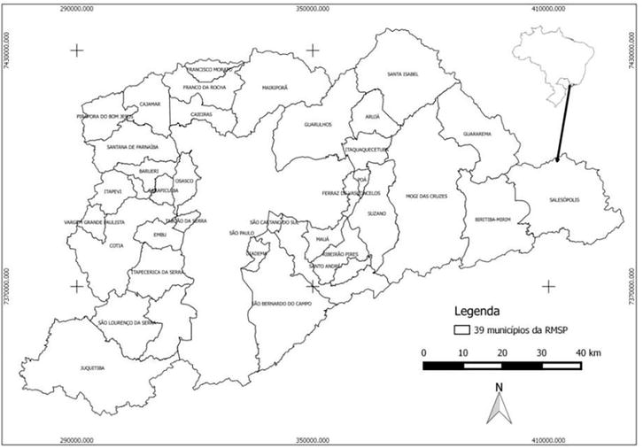
The Metropolitan Area of São Paulo, MRSP, is composed of 39 municipalities that cover a total area of 8051 km2 [10] and has a population of over 22 million people (Figure 1).
Figure 1.
Map of RMSP from the atlas of socio-environmental vulnerability of the metropolitan region of São Paulo.
Moreover, MRSP is one of the most populated and economically important regions in Brazil, but it also faces several environmental problems, including air pollution, water pollution—Tietê and Pinheiros rivers, which flow through the metropolitan area, are highly polluted due to untreated sewage, industrial waste, and runoff from urban areas, deforestation due to urbanization that has led to the loss of habitat and biodiversity, soil erosion, degradation of vegetation cover that also increased risk of landslides and flooding. Addressing these environmental problems requires a comprehensive approach that involves policy and regulatory frameworks, public education and awareness, and investments in technologies to promote sustainable development. Hence, considering the objective to increase the vegetation cover and the carbon credits of at the MASP, a group of 13 researchers from various fields, worked remotely and simultaneously in a workshop using the GISColab platform1. This platform was developed within the scope of the Geoprocessing Laboratory of the School of Architecture of the Federal University of Minas Gerais. It has a flexible approach that is adapted to the Brazilian context, which works according to the Geodesign framework. The combination Geodesign framework and the GISColab platform allowed the codesign of ideas and plans for large regions, and are especially suitable for remote work during the pandemic.
It is emphasized that Geodesign improves the design and planning process that together with the Geographic Information System (GIS) can contribute to works that aim at the sustainability of the area and meet the population’s goal of environmental quality [12]. The Geodesign process typically involves several stages, including problem identification, data analysis and modeling, design alternatives, evaluation and selection of the best alternative, and implementation and monitoring. In this sense, Geodesign also involves the iterative design and feedback loops to refine, and improve the solutions. And it has been used to promote and plan intelligent landscapes. In a nutshell, promoting and planning intelligent landscapes involves designing and managing landscapes that are sustainable, resilient, and responsive to the needs of people and the environment. Geodesign process is open for the integration of diverse stakeholders, including local communities, government agencies, and businesses, to develop strategies that balance competing priorities and promote sustainable development.
So that green spaces can be relevant to support the bodies and decisions of urban planning, aiming at the conservation and management of spaces [13].
It is necessary to develop viable alternatives for the implementation of green areas in the cities, where it is necessary to think about their distribution in public and private facilities, distribution in the cities and among the communities, covering their occupation in the use of the soil, making their application viable, escaping from the onerous pattern and longtime demand of the cost involved that has been used [14].
In this way, the use of Geographic Information System (GIS), can assist in landscape planning, aiming to increase urban forestation. GIS presents a flexible environment for input, analysis, and mapping of data for land use and land cover, for example Ref. [15].
Initially, the available database on the GISColab platform was analyzed by the participants, who identified the most relevant layers to the MRSP case and highlighted essential data, which had not been covered by the national project organization, such as layers of urban heat island and flooding prone areas, available at the MASP’s Socio-Environmental Vulnerability Atlas, and information about contaminated areas, landfills, and postindustrial areas, where increased afforestation can be of especial benefit (Figure 2).
Figure 2.
Geodesign workshops workflow. Source: Authors. Adapted from IGC, 2021.
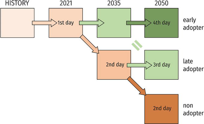
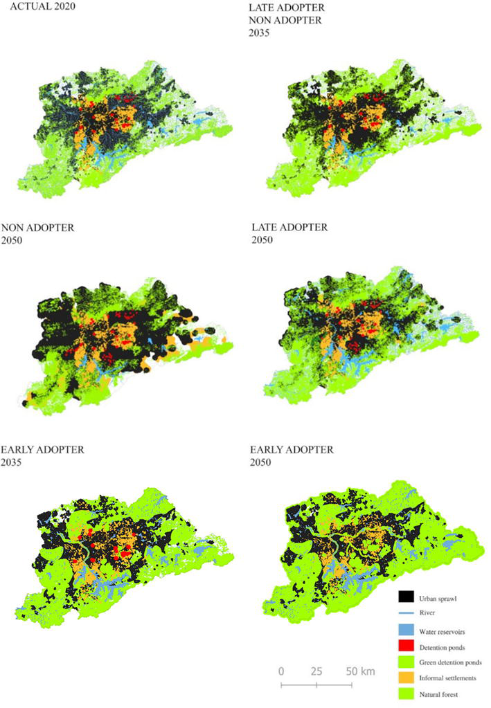
With the main objective of achieving the objective of establish an urban forest, improving the street trees, water managing, and natural and planted forest areas, decreasing the phenome of urban heat islands in the early, late, and non-adopter scenarios (Table 1).
Current
Early
Late
Non
References
2020
2035
2050
2035
2050
2050
Number of street trees based on the balance between planted and fallen plus removed trees.
Predicted changes of the metropolitan region of São Paulo.
Adapted from IGC, 2021.
About the late-adopter (2035) and non-adopter (2050) the values of increasing or decreasing percentages related to 2020/21 were estimated for 2035 and 2050 by evaluating the linear trends from historical datasets starting in 1985 up to the present. Finally, the information obtained was compared with 2020/21 in relative terms. In order to predict urban sprawl, two main sources of information were used. The census [22] provided an overview of the slums increment and distribution until 2010, in addition to the data available on MapBiomas for the evaluation of natural and planted forest and urban settlement areas (MapBiomas/IBGE)2. For street trees, data from the Municipal Plan for Urban Trees [23] were used, including data on tree fall, replacement of senescent individuals, and planting. For the Late adopter (2050) and Early adopter (2035 and 2050) changes in tree cover are presented in percentages related to 2020/21. For these projections, goals for afforestation of the MRSP were discussed and defined among the different researchers during the workshop.
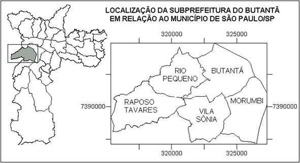
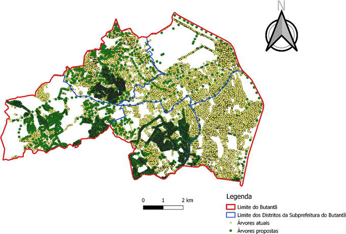
In order to obtain an increase in street afforestation, a study was made aiming to increase this in the Butantã Subprefecture, located in the Municipality of São Paulo that is in the MRSP (Figure 3). The GIS resource was used, with the use of the free software QGIS, proposing a geodesign map (Figure 4).
Figure 3.
Location of the Butantã subprefecture in the municipality of São Paulo.
Figure 4.
Map of Butantã, with a proposal for increasing urban forestation.
There are in this Subprefecture both high-standard areas, mainly in Morumbi, from middle-class neighborhoods to slums. But in general, it is a very expressive population of medium to high socio-economic status [24].
This geodesign-based map is the intersection between the 2013 afforestation map and the proposed afforestation map. It demonstrates the proposed geodesign for the study area as a nature-based solution. Thus, one can visualize the green infrastructure gain with emphasis on urban road forestation in the Sub-municipality of Butantã, obtaining a total of 54,469 mapped trees [25].
This work showed that the Butantã Subprefecture, in 2013, had 33% of tree canopy, with this proposal to implement the tree canopy, the green area is increased by 3%, totaling 36% of green infrastructure with emphasis on tree canopy, which represents an amenity of 1.5°C, as follows (Table 2).
Period
Total tree canopy area
Percentage of green infrastructure
Medium temperature
2013
10,18 km2
33%
24.86°C
Proposal
11,80 km2
36%
23.36°C
Table 2.
Status of the Butantã Subprefecture in total area of tree canopy, percentage of Green Infrastructure and average temperature in 2013 and the change with the proposal to implement the tree canopy [25].
The workshop that was made took place remotely, which take place to use the GIS and Geodesign approach, having the main objective to increase the vegetal cover in urban, peri-urban, and rural areas, in public and private property, and they were related mainly to the conservation of protected areas and existing vegetation, the ecological restoration of riparian forests, and adequate management of the urban afforestation and planning guidelines for the new green areas to be proposed in the MRSP.
For the measurement of various data, such as rainfall density or quantification of urban forestation, geospatial technology, such as Remote Sensing (RS), Geographical Information Systems (GIS) and Global Positioning System (GPS) has been advancing and prevailing in many terrain space and urban planning surveys, aiming for accurate, continuous, and highly precise results [12].
Geodesign provides a framework of methods and technologies for building skills and indicators. Being an improved technological method that merges the rigid form with the planning proposal with impact simulations that occur in the geographic context [22].
As examples of these strategies, one can mention the support to plant trees in particular areas through public policies and environmental compensation mainly for the construction industry, the support to plant along avenues, and the transformation of MRSP’s roads landscapes.
It is necessary for the importance of implementing afforestation in the analysis of the landscape, respecting the species with their ideal planting location, when there is a drastic intervention with irrigation and not attention to the planting location, demonstrating that the species are not in ideal locations for their typical climatic conditions. On the other hand, commercial forestry trials are established to evaluate the suitability of species and provenance [26].
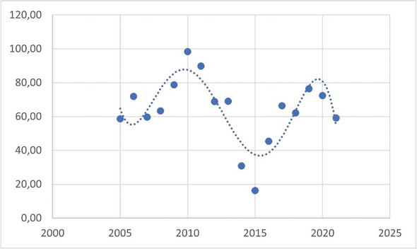
The water supply is also prone to the effects of increasingly frequent climate extremes, such as the drought caused by an unusual mid-troposphere blocking, during the summer of 2014 [27]. Due to the observed values of the total volume of water in the reservoirs of the MRSP [28], very low in 2005, 2014, and 2015, also the downward trend from 2020 and the forecasts of specialists estimates there is a tendency to reduce the volume of water available for supply. At the end of 2014, the system had a negative 2% total volume compared to normal.
With respect to the theme of water reservoirs, Figure 2 illustrates a trend toward a reduction in the percentage of total volumes, starting in the years 2020–2021. The years 2014 and 2015 were critical for the supply system, characterizing a real water crisis at MASP. The calculations made from the equation obtained from the trend line of the graph in Figure 5 showed a reduction in the percentage of the total volume of the reservoirs, as shown in Table 1.
Figure 5.
Percentage of the total volume of MASP reservoirs in relation to the year.
Moreover, it is important to point out that in this scenario, significant environmental, social, and economic changes will occur within and outside cities as they grow in size and complexity, economic losses and poor livelihood are also a result of the higher vulnerability of cities to extreme precipitation events [29].
In order to achieve the goal of increasing urban forestation in the study area, one must think about the change that can be obtained in the city from 2035 to 2050 (Figure 6). In order to occupy the land use in a balanced way that promotes the quality of life of the inhabitants and the main focus of this work is the increase of urban forestation. Nature-based solution is widely used to promote socio-environmental quality.
Figure 6.
Spatial distribution of the most relevant layers of the metropolitan region of São Paulo 1. Adapted from IGC, 2021.
3.1 Nature-based solution (NbS)
The NbS arise as a way to use environmental sciences to solve problems such as mitigating climate change, improving sustainable livelihoods, and protecting natural ecosystems and their biodiversity [14].
The importance of adapting buildings and urban areas, the implementation of green areas, as a means of increasing the humidity of the area, and being proactive urban [27].
Trees are essential elements in nature-based solutions, as they simultaneously promote quality of life and biodiversity while providing mitigation and adaptation ecosystem services in cities [6].
Therefore, the focus in research about urban planning should be on central areas that have a large accumulation of vacant buildings.
These policies should provide structure for urban redevelopment projects through urban design with nature-based solutions and green infrastructure, in a wide participatory and inclusive manner, by maintaining the population in the site, but within a secure and eco-friendly condition. In addition, one must also consider the relationship between trees and urban water.
In the scenario of 2050, the main proposal was to increase tree coverage in the built area, then the group discuss real examples of sustainability and resilience cities, such as Singapore, and also the revision of local experiences such as Maringá city, Brazil. They are public policies that encourage urban planting and afforestation, considering its ecosystem services; redesigning existing streets with nature-based solutions and focus on the implementation of urban forestry.
Thus, to achieve a resilient urban ecology, it is necessary to think of the landscape as an interdisciplinary field, with heterogeneous elements, without ignoring its natural rhythm of intensity and disturbances. Environmental management of public policy can adopt the adaptive concept, where there is room to work out the uncertainties of the natural and urban environment and learn in the process, in order to improve management [26].
Resilience requires, that there is urban landscape planning, identifying the disturbances that it has and seeking solutions, of how the study area can adapt to respond to the disturbances that the urban environment can generate in nature that affect the socio-environmental quality of life [30].
Sustainability meets NbS, which can be applied in urban and landscape planning, provided that the contrasts of the urban area and its fluidity are understood. Thus, important that resilience theory is applied, aiming for a solution to the challenges of sustainability [26].
Also, the application of NbS needs stakeholders and decision-makers to find reliable alternatives to usual monofunctional heavy engineering solutions that are becoming inadequate to cope with the complex environmental, social, and economic challenges of cities [31].
This chapter discussed how urban trees can provide a wide range of ecosystem services that benefit both the environment and people living in MRSP. Some examples of ecosystem service provided by urban trees are the improvement of air quality by absorbing pollutants, such as nitrogen oxides and particulate matter, which can have negative health impacts, carbon sequestration, and temperature regulation—which can help to reduce the urban heat island effect and lower temperatures in urban areas, stormwater management and biodiversity conservation.
The Geodesign framework, following Stein’s framework with the GISColab platform, assisted in the dynamics and integration of the landscape aimed at understanding the study area, visualizing the challenges, and pursuing NbS.
According to the scenarios, it was observed if no measures are taken for changes that favor natural resources in the landscape, environmental degradation, increased urban heat island and reduced water supply. By 2035, the trends would be similar. However, if adaptations in urban planning were made, innovative technologies would be used, aiming to implement greater afforestation and in the search for NbS for the MRSP.
It is noteworthy that the work with GISColab allied with GIS, was important at the time when the work took over, due to the pandemic situation can be done remotely and unite several researchers to collaborate in the elaboration of different scenarios of the urban canopy of MRSP.
Finally, this chapter also argued—in an exploratory fashion—about how to promote and plan intelligent landscapes, such as addressing the environmental problems MRSP. Important process is to identify the specific environmental problems facing the MRSP to design and plan that integrate ecological, social, and economic considerations, such as implementing green infrastructure, promoting sustainable transportation, and creating green spaces for public use. Overall, in the case study, urban trees play a vital role in providing ecosystem services in MRSP that benefit both the environment and people living in urban areas. By planting and maintaining urban trees, São Paulo can promote a more livable, healthy, and sustainable neighborhood.
Thanks
The authors would like to thank Ana Clara Moura (UFMG) who coordinated the project “Geodesign Brasil: Trees for Metropolitan Regions;” for the support of the Geoprocessing Laboratory (Geoproea/EAUFMG) staff; and the GISColab platform (CNPq Project 401,066/2016–9/FAPEMIG PPM-00368-18). And this work was carried out with support from the Coordenação de Aperfeiçoamento de Pessoal de Nível Superior—Brazil (CAPES)—Funding Code 001.
References
1.da Silva Filho DF et al. Urban forest indicators from high resolution multispectral aerial imagery. Scientia Forestalis/Forest Sciences. 2005:88-100
2.Torres H, Alves H, Oliveira MA. São Paulo peri-urban dynamics: some social causes and environmental consequences. Environment & Urbanization. 2007;19(1):207-223. DOI: 10.1177/0956247807076784
3.Sant’Anna CG. A infraestrutura verde e sua contribuição para o desenho da paisagem da cidade [thesis]. Brasília: Universidade de Brasília; 2020
4.Botton GZ et al. As construções das abordagens conceituais de cidades sustentáveis e inteligentes para superar os desafios dos objetivos do desenvolvimento sustentável. Desafio Online. 2021;9(3)
5.Locosselli GM, Miyahara AL, Cerqueira P, Buckeridge MS. Climate drivers of tree fall on the streets of São Paulo, Brazil. Trees. 2021:1-9. DOI: 10.1007/s00468-021-02145-4
6.Maruyama CC, Fruehauf AL, Lombardo MA. Infraestrutura Verde para mitigação de Ilha de Calor e sequestro de carbono da Região Metropolitana de São Paulo. In: Fruehauf AL, Rosa AA, Maruyama CC, Coelho MA, editors. Geodesign no Brasil: abordagens para o planejamento ambiental urbano. São Carlos, SP: Pedro & João Editores; 2022
7.Gonçalves JM, Gama JMRF. A systematization of policies and programs focused on informal urban settlements: Reviewing the cases of São Paulo, Luanda and Instambul. Journal of Urbanism. 2020;13(4):466-488. DOI: 10.1080/17549175.2020.1753228
8.Gómez-Baggethun E, Barton DN. Classifying and valuing ecosystem services for urban planning. Ecological Economics. 2013;86:235-245
9.Konijnendjik CC. A decade of urban forestry in Europe. Forest Policy and Economics. 2003;5(2):173-186. DOI: 10.1016/S1389-9341(03)00023-6
10.Instituto Brasileiro de Geografia e Estatística. Censo Brasileiro de 2010. Rio de Janeiro: IBGE; 2012
11.Steinitz C. A Framework for Geodesign: Changing Geography by Design. Redlands: ESRI Press; 2012
12.Brito FM, Miralgia SGEK, Semensatto DL Jr. Ecosystem services of the Guarapiranga reservoir watershed (São Paulo, Brazil): Value of water supply and implications for management strategies. International Journal of Urban Sustainable Development. 2018;10(1):49-59. DOI: 10.1080/19463138.2018.1442336
13.de Almeida ALBSS. The Value of Trees: Trees and Urban Forest in Lisbon [Thesis]. Lisbon, Portugal: Universidade Técnica de Lisboa Instituto Superior de Agronomia; 2006
14.Cohen-Shacham E et al. Nature-Based Solutions to Address Global Societal Challenges. Vol. 97. Gland, Switzerland: IUCN; 2016
15.Liu T, Yang X. Monitoring land changes in an urban area using satellite imagery, GIS and landscape metrics. Applied Geography. 2015;56:42-54
16.São Paulo (Prefeitura), Fundação Centro Tecnológico de Hidráulica (Org.). Caderno de bacia hidrográfica: córrego Jaguaré. São Paulo: Siurb/FCTH; 2016
17.Sabesp, Companhia de Saneamento Básico do Estado de São Paulo: Portal dos mananciais. Available from: http://mananciais.sabesp.com.br/Situacao [Accessed: April 29, 2021]
19.São Paulo (Prefeitura). Plano Diretor de Macrodrenagem da Bacia do Alto Tietê. São Paulo, SP: Departamento de Águas e Energia Elétrica; 2013
20.Pasternak S, Bogus LM. Favelas na Macrometropole Paulista. In: A Seminario Internacional de Investigación en Urbanismo. XII Seminario Internacional de Investigación en Urbanismo, São Paulo-Lisboa, 2020. São Paulo: Faculdade de Arquitetura da Universidade de Lisboa; 2020. DOI: 10.5821/siiu.10116
21.Lombardo MA. Ouso de geotecnologias na análise das mudanças climáticas na metrópole de São Paulo. Revista Geográfica de América Central. 2011;2:1-19
22.Dangermond J. Geodesign and GIS–designing our futures. Proceedings of Digital Landscape Architecture. 2010:502-514
23.Moreira TCL, Polizel JL, Santos IS, Filho DFS, Bensenor I, Lotufo PA, et al. Green spaces, land cover, street trees and hypertension in the megacity of São Paulo. International Journal of Environmental Research and Public Health. 2020;17(3):725. DOI: 10.3390/ijerph17030725
24.Morato RG, Kawakubo FS. Análise espacial da desigualdade ambiental na subprefeitura de Butantã, São Paulo-SP. Revista brasileira de geografia médica e da saúde. 2007:66-73
25.Fruehauf AL. Analysis of Land Use, Thermal Field and Vegetation Index for the Implementation of a Green Infrastructure in the Search for Urban Environmental Quality in the Butantã Subprefecture, in the Municipality of São Paulo-SP [Thesis]. Piracicaba, Brazil: Luiz de Queiroz College of Agriculture, University of São Paulo; 2020. DOI: 10.11606/D.11.2020.tde-01102020-171031
26.Ahern J. From fail-safe to safe-to-fail: Sustainability and resilience in the new urban world. Landscape and Urban Planning. 2011;100(4):341-343
27.Marengo JA, Alves LM, Ambrizzi T, Young A, Barreto NJC, Ramos AM. Trends in extreme rainfall and hydrogeometereological disasters in the metropolitan area of São Paulo: A review. Annals of the New York Academy of Sciences. 2020;1472(1):5-20. DOI: 10.1111/nyas.14307
28.Mcpherson EG, Simpson JR, Peper PJ, Xiao Q. Benefit-cost analysis of Modesto’s municipal urban forest. Journal of Arboriculture. 1999;25(5):235-248
29.Emplasa, Empresa Paulista de Planejamento Metropolitano S/A. Biblioteca Virtual. São Paulo, SP, Brasil; 2022
30.Vale L, Campanella J, Thomas J. The Resilient City: How Modern Cities Recover from Disaster. Oxford, UK: Oxford University Press; 2005
The Brazilian Geodesign platform - GISColab has the premise of supporting and connecting Spatial Data Infrastructure (SDI), WebGis, and Geodesign in order to provide integrated and georeferenced information on the territory, enabling a wide availability of data to support the discussions and negotiations on the adopted spatial profile [Locosselli]. Available at: <GisColab: http://www.giscolab.com/geodesign/#/
The Expressive Vegetation Map in GISColab was based on Vegetable Cover Maps of Brazilian Biomes (http://mapas.mma.gov.br/mapas/aplic/probio/datadownload.htm?/mosaicos_vegetacao/) and developed by GeoPrea Laboratory (EAU/UFMG).
Written By
Amanda Fruehauf, Adriana Afonso Sandre, Magda Lombardo and Paulo Renato Mesquita Pellegrino
Submitted: 01 March 2023Reviewed: 08 March 2023Published: 21 September 2023
 Open access peer-reviewed chapter