Open Access is an initiative that aims to make scientific research freely available to all. To date our community has made over 100 million downloads. It’s based on principles of collaboration, unobstructed discovery, and, most importantly, scientific progression. As PhD students, we found it difficult to access the research we needed, so we decided to create a new Open Access publisher that levels the playing field for scientists across the world. How? By making research easy to access, and puts the academic needs of the researchers before the business interests of publishers.
We are a community of more than 103,000 authors and editors from 3,291 institutions spanning 160 countries, including Nobel Prize winners and some of the world’s most-cited researchers. Publishing on IntechOpen allows authors to earn citations and find new collaborators, meaning more people see your work not only from your own field of study, but from other related fields too.
To purchase hard copies of this book, please contact the representative in India:
CBS Publishers & Distributors Pvt. Ltd.
www.cbspd.com
|
customercare@cbspd.com
A cascade dam system poses more hazards for downstream life and structures, when compared with a single dam located on a river. Therefore, there is a need to develop differentiated procedures to classify and regulate these dams. In the state of Mato Grosso (MT), Brazil, it is common to find multipurpose dams, which can be considered as a cascade, when a dam failure causes adverse effects in downstream dams. The objective of the study is to analyse the possibility of dam failure located in the cascade system operated by the municipality of Várzea Grande, MT by the Associated Potential Damage (APD) classification used throughout the country. In order to do this, the specification namely “Simplified Methodology to Define the Classification Flood Zone of Associated Potential Damage of a Dam” developed by the National Laboratory for Civil Engineering in Portugal (LNEC in Portuguese) was utilised. This specification was adapted by the National Water and Sanitation Agency (ANA in Portuguese) in Brazil. In the case study, there are three dams (Dam 1, Dam 2 and Dam 3) in the cascade system. Dam 1 can cause overtopping problem for Dam 2 and Dam 3. According to APD classification, dams considered for the study are categorised as “high dam”.
The increase in the number of dams has increased the concern with the safety of these structures [1]. Major accidents with dams have drawn attention to this problem, as failures in these structures can cause irreversible environmental damage, as well as human and animal deaths.
Advantages in the implementation of cascade dam projects have made this conception commonplace and risk analysis a complex activity. The advantages of these projects include simplifications derived from decentralisation (lower cost, implementation time and complexity to comply with legislation); the possibility of storing water to generate electricity in downstream dams; the transformation of stretches that are not navigable into waterways; full use of the flow of water; the development of rolling projects; and coordinated dispatch of energy [2, 3, 4].
Within this context, numerous studies have been developed to provide subsidies for operation, maintenance and decision-making in the area of dams. Some of these studies are briefly presented in the sequence. In a work on the Dadu River basin, one of the main rivers in China, transmission risk and overtopping between dams in cascade reservoirs were studied [3]. Dam risk was divided into two parts: own risk and additional risk. Based on this, a methodology that considers the relevant concepts and equations for calculating the risk probability of dams in cascade reservoirs was proposed. The results indicated that the proposed methodology realises an effective connection with the risk calculation of the single-reservoir dam method, which can provide a reference for the risk assessment and management of cascaded reservoirs in the basin [3].
The research focused on the genetic-algorithm-based optimisation of rule curves to maximise hydropower and associated benefits through cascading reservoirs [4]. The optimisation was performed using RESOOSE model and applied to multipurpose Diamer Basha and Terbela reservoirs on Indus River in Pakistan. According to [4], the results show that hydropower was optimised along with the maximisation of associated benefits (power generation, irrigation and sediment discharge).
A study to describe the principles of dam risk classification methods, the International Commission on Large Dams (ICOLD) method and the Bureau method, and comparatively discussing total risk classifications was carried out by Topcu and Tosun [5]. In conclusion, the following stand out: the safety assessment for cascade dams should be different from that of a single dam; the rupture of any dam in a cascade structure may result in overtopping or breakage of the dam or dams downstream; the probability of rupture of any dam in a cascade structure is higher than that of a single dam; and a new safety concept should be developed for dams in a cascade system [5].
Some topics considered important for the study of dam safety in Brazil are presented in the following.
2.1 National dam safety policy
In this context, the National Dam Safety Policy (PNSB in Portuguese), established by [6] and amended by [7] aims to ensure that dam safety standards are followed (mainly by developers) to reduce the possibility of accidents and their consequences, as well as regulate safety actions and standards. The policy defines a dam as any structure built inside or outside a permanent or temporary watercourse, in a thalweg or in a diked pit, for the purpose of containment or accumulation of liquid substances or mixtures of liquids and solids, comprising the dam and associated structures.
2.2 Dam safety plan
An important instrument of the National Dam Safety Policy, which must be implemented by developers, is the Dam Safety Plan (PSB in Portuguese), whose objectives are to assist and serve as a planning tool in the dam safety management. In the Dam Safety Plan structure, the information and technical data of the dam referring to construction, operation, maintenance and the overview of the current state of safety, obtained through regular periodic inspections, must be documented. For multipurpose dams inspected by the National Water and Sanitation Agency, this agency issued [8] establishing the implementation of procedures, including the minimum content and level of detail of the Dam Safety Plan.
Depending on the conditions of each dam, the Dam Safety Plan may require preparing up to six volumes, distributed as follows: Volume I—General Information; Volume II—Technical Documentation of the Project; Volume III—Plans and Procedures; Volume IV—Records and Controls; Volume V—Periodic Review of Dam Safety (PRDS); Volume VI—Emergency Action Plan (PAE), when required.
2.3 Dam classification
Dams can be built for various uses, including irrigation, aquaculture, human water supply, industrial water supply, animal watering, leisure, fishing, electricity generation and disposal of mining and industrial tailings, among others.
Dam classification consists of an instrument of the National Dam Safety Policy and is a procedure normally carried out by inspection bodies, following the criteria of [9], and was established by the National Water and Sanitation Agency, the Risk Matrix and Associated Potential Damage. It is known that currently (in 2022), there are negotiations to be carried out with the updating and adequacy of the Brazilian National Council of Water Resources (CNRH) definitions and recommendations.
According to the aforementioned law and its amendments, the definition refers to the classification of the dam risk category (DRC) by the associated potential damage (APD) and by its reservoir volume. In the DRC, aspects that may influence the possibility of an accident or disaster are verified, taking into account the technical characteristics and the state of conservation, and the Dam Safety Plan, that is, the conditions of the risk of dam accidents due to failure or lack of adequate actions, is the developer’s responsibility.
On the other hand, the APD refers to damage that can occur due to failure, leakage, infiltration into the soil or malfunction of a dam, regardless of its probability of occurrence, to be graded according to the loss of human life and social impacts, economic and environmental.
The dams must be classified into five classes (A, B, C, D and E, presented in (Table 1), and those that present a higher degree classification, in the risk category scale and associated potential damage, must prepare a more complete plan.
Risk category
Associated potential damage (APD)
High
Medium
Low
High
A
B
C
Medium
A
C
D
Low
A
C
E
Table 1.
Risk matrix and associated potential damage.
Currently, Brazil has 22,649 dams registered by 33 inspection bodies in the National Information System on Dam Safety (SNISB in Portuguese). There are 6507 dams assessed by DRC, and of these 2503 were classified as high DRC; there are 1388 dams assessed by APD, and of these 871 were classified as high APD.
2.4 Situation of cascade dams
The state of Mato Grosso, located in the Central-West region of Brazil, has five Dam Safety inspection bodies: (1) Mato Grosso State Secretariat for the Environment (SEMA-MT in Portuguese) inspects dams intended for multiple uses, located in state rivers; (2) National Water and Sanitation Agency (ANA in Portuguese) inspects dams intended for multiple uses, located in federal rivers; (3) National Mining Agency (ANM in Portuguese) inspects dams destined for the disposal of mining tailings; (4) National Electric Energy Agency (ANEEL in Portuguese) inspects dams intended for generating electric energy; (5) Brazilian Institute of Environment and Renewable Natural Resources (IBAMA in Portuguese) inspects dams intended to contain industrial waste. However, only four of these bodies are effectively inspected, except for IBAMA.
According to the National Information System on Dam Safety, there are currently 652 dams registered in the state of Mato Grosso. Of these, 262 are inspected by the Mato Grosso State Secretariat for the Environment, 132 by the National Water and Sanitation Agency, 141 by the National Mining Agency and 117 by the National Electric Energy Agency.
Dam safety has been a very important item for a long time, although in Brazil, the development of regulatory actions only took place after Law No. 12,334, on November 20, 2010. The improvement of actions evolved after the Inspection Agencies (federal and state) issued the respective regulations.
After establishing the National Dam Safety Policy, there were advances in dam classification and regularisation in Brazil. However, progress is still needed in terms of inspectors’ performance, specifically in dam regularisation (issuance of grants and environmental licences, among others), construction and refinement of registries, inserting dams into the National Information System on Dam Safety, dam classification, reviewing regulations [6] and on-site and documentary inspection actions. Most dams were not regularised and/or included in the National Dam Safety Policy by the inspection entities due to a lack of basic information such as height and volume, or because they were not classified as to the APD, or because of the difficulty in identifying the responsible developer [10].
As in several states in Brazil, the state of Mato Grosso also has problems regarding the safety of multipurpose dams located in state water bodies, as presented in [11]. This is because the competence in the state for managing civil works, such as dam construction, is carried out by another sector of the Mato Grosso State Secretariat for the Environment, which deals with environmental licencing, requiring strong coordination between the Water Resource Superintendence and other areas of the secretariat to carry out the actions proposed by the National Water and Sanitation Agency, as in the case of dam regularisation in terms of licencing, granting and dam classification, together with the fact that the state also has recently published regulations for dam regularisation.
Most multipurpose dams, located in existing state water bodies in the state of Mato Grosso, were predominantly built on land; they have a small reservoir area and height and are mostly characterised as small dams. They are mostly located on rural properties, with predominant uses for irrigation and aquaculture activities. These dams are, in many cases, maintained (not so adequately) by small developers who usually do not have sufficient technical knowledge for more accurate assessments and/or financial resources to hire qualified professionals. This situation is common in several regions of Brazil and in other parts of the world [12].
It was noted that the vast majority of them are located mainly on farms, but far from the sites where the caretakers are. Thus, there is little or no concern with dam safety on the part of developers, mainly due to the absence of specific regulation, until mid-2017, and, consequently, a lack of guidance, a lack of disclosure and notification and/or lack of knowledge. Most dams do not have a technician responsible for the structure and were built without having a project, without constructive care and without environmental licencing. Some were built for access purposes, on irregular terrain and ended up damming (rain) water. These normally do not present dam aspects, but they present risks because of the lack of adequate executive and maintenance conditions.
The dams in the best safety conditions are those that have the “regular road function”. In this case, there is no excess vegetation, at least at the crest of the dam. It can also be observed that the excess vegetation, a common characteristic found in the dams of the state, is part of a culture of the developers and employees of the farms, who must believe that the excessive vegetation (mainly trees on the crest) on the slopes would protect the dam. However, it is the opposite.
In the visits to the dams, it was noticed that some conditions are recurrent in the state’s dams and require care and maintenance, such as excess of high vegetation on the crest and slopes; crest cracks; fissures and erosion on the slope; infiltration moisture, on the downstream slope; and structures close to roads, which can cause socio-environmental impacts (and even deaths) in the event of a possible failure.
Most of the dam accidents, that had a loss of life, occurred in small and/or medium dams, with a height of less than 30 meters. Therefore, these dams have become a matter of concern and of greater interest to dam safety professionals [13].
In the state of Mato Grosso (MT), it is common to find these small dams located in the same watercourse (or in thalwegs), which can be sequential (when there is no negative effect of a dam on the downstream dam) or in cascade. Many are located close to highways and/or other infrastructure, which may represent high APD.
Dam failure is considered as a cascade, when the occurrence of an extreme event (with loss of resistance, or overtopping and/or overflowing) of one of them, generating a burst flood wave, may indicate that it serves as a cause for the possibility of failure of another dam, existing downstream (in the same watercourse or thalweg).
Each developer should manage the dams they own properly, so as not to assign additional risks to other dams in the cascade, which may even belong to other developers. The flood wave caused by a failure is generally greater than the design flow and capacity of the dam spillway or spillway immediately downstream, as the reservoir volume is released in a short time interval. This flood wave can cause the downstream dam to overflow (“overtopping”) and failure [14].
Given that in the state of Mato Grosso, there have already been cascading failures, which is a concern for the inspection body, there is a need to develop differentiated procedures for the regularisation and classification of these structures. Thus, the objective of the study is to analyse the possibility of failure, according to the conditions of dams located in the same watercourse (or thalweg), in the municipality of Várzea Grande, MT. APD classification is also made possible of these dams and, thus, presents a procedure (or protocol) for the APD classification of dams located in the same body of water (or thalweg).
To analyse the negative influence of a dam failure in other dams located in the same watercourse, the “Simplified Methodology to Define the Classification Flood Zone of Associated Potential Damage of a Dam” was used. This methodology is currently used by the National Water and Sanitation Agency to classify dams within the competence. It is a methodology developed at the National Laboratory for Civil Engineering in Portugal for the National Water and Sanitation Agency, which generates a reference area or polygon for APD estimation. The methodology assumes that the available data from both the dams and the relief do not allow the accurate modelling of the failure. Thus, the appropriate methodology was simplified so as to use the Shuttle Radar Topography Mission (SRTM) as a digital elevation model and a minimum of input data without describing the geometry of both the dam and the downstream flow channel.
Therefore, the objective of this area is only to delimit the area of analysis to classify the APD. It is similar to a flooded area; however, we cannot understand it as an exact flood area, due to insufficient data precision, especially the relief data (30 m SRTM). It is limited to being a reference on which the public agent, or the dam safety supervisory body, can be based to prioritise its performance [15].
According to [15], the methodology (considering the area downstream of the dam and some cross sections, reference and control) consists of the following procedures:
Empirical calculation of the length of the river to be modelled.
Verification of the adequacy of the determined limit, analysing the occupation and geomorphology of the valley downstream of the dam.
Calculation of the maximum flow associated with the dam failure.
Calculation of peak flows in each of the cross sections along the valley.
Comparison of the damped flow in each cross section along the valley with the maximum flow of the spillway.
Obtaining the altimetry of points along the cross sections.
Hydraulic calculation to estimate the maximum level of the failure wave in each of the cross sections.
Creation of the surface surrounding the failure wave.
Obtaining the polygon, for the APD classification.
Possible adoption of adjustments, to consider specific characteristics of the site.
To generate the area, it is necessary to use the ArcGis software. In the study, version 10.5 was used. In addition, the following additional data are required:
SRTM 30 m.
Reservoir volume (hm3).
Height of the dam (m).
Crowning quota (meters above mean sea level, m).
Satellite images.
The risk analysis of cascading failure of the dams (selected) occurred from thematic maps with the classification areas, where they were evaluated according to the aspects of the classification of the APD presented in [16], such as total volume of the reservoir; potential for loss of human life; environmental impact and socio-economic impact.
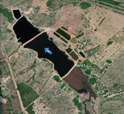
For the analysis, a case study was carried out using dams 1 (B1), dam 2 (B2) and dam 3 (B3) located in Ribeirão Esmeril, a municipality of Várzea Grande, Mato Grosso and presented in Figure 1.
Figure 1.
Dams used to analyse the negative influence of dams located in the same watercourse.
The structures were built using homogeneous land as material, with priority use for aquaculture activity. These dams are registered with the Mato Grosso State Secretariat for the Environment Water Resource Superintendence. They were inspected in 2016 and have data collected in the field by technicians from the inspection body (SEMA-MT).
The location and height of the dams were obtained from the Mato Grosso State Secretariat for the Environment survey report. The volume was estimated from the wetland and height of the dam. Additional information on the dams includes: foundation on soil; embankment dam formed of compacted earth, material homogeneous; construction date, unknown; volume of dam 1 = 0.24 hm3; volume of dam 2 = 0.50 hm3; volume of dam 3 = 0.39 hm3; height of dam 1 = 2.7 m; height of dam 2 = 4.8 m; and height of dam 3 = 6.3 m. The crest of the dams was obtained from Google Earth. The input data used in the simulations are shown in Table 2.
Simulation
Scenario
Estimated volume (hm3)
H (m)
Crowning quota (m)
S1
Isolated failure of B1 dam
0.24
2.7
175
S2
Isolated failure of B2 dam
0.50
4.8
174
S3
Isolated failure of B3 dam
0.39
6.3
173
S4
Failure of B2 and B3 dams
0.89
6.3
173
S5
Failure of B1, B2 and B3 dams
1.13
6.3
173
Table 2.
Input data for generating the APD classification area, considering different scenarios.
In the simulations, to analyse the negative influence of dams located in the same watercourse, some scenarios were considered, where they could occur:
Isolated failure of each of the dams, according to the recommendations of [15].
Cascade failure of dams B2 and B3, where the initial failure occurs in dam B2, but given the limitations of the application, it is considered as occurring in dam B3, adding the volumes of water stored in the two structures (volume of dam B2 added to the volume of the B3 dam), as if it were only in the B3.
Failure of the three dams. In this case (given the limitations of the methodology), the modelled failure occurs in dam B3 and the volume considered in the simulation was the sum of the volumes of the three dams.
As the methodology for generating the classification area can only consider data from only one dam, for the cascade failure scenarios (simulation S4 and S5), the simulation was started at the last dam where the failure would occur.
Therefore, the height and crown height data used in the S4 and S5 simulations were the data from the B3 dam, while the volume used was the sum of the three reservoirs.
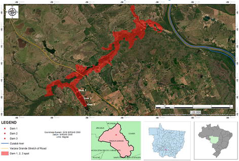
Figure 2 shows the classification area considering only the B1 failure.
Figure 2.
Area generated considering simulation 1.
By analysing the isolated areas and the values of the maximum levels obtained, it can be observed that the failure of the upstream dam (dam B1) would probably cause the failure of dams B2 and B3, as the maximum levels obtained in the simulation of dam B1 in the sections of dams B2 and B3 are 175.32 m and 174.33 m, respectively. The heights of the crest of these dams are 174 m and 173 m, respectively.
Thus, by the simulation, the water could pass over the crest of these dams, which would probably cause a sequential failure by overtopping.
A similar situation occurred with the maximum levels of the isolated failure simulation of dam B2. In this case, the wave would probably cause water to pass over dam B3, according to the simulation, as the maximum height of the flood wave in the section where dam B3 is located is 174.89 m and the crest level of that dam is 173 m.
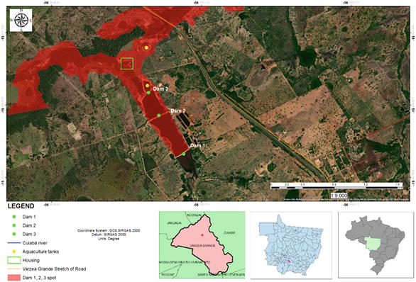
Figure 3 shows that the areas generated by the cascade failures are larger than the areas considering the isolated dam failures.
Figure 3.
Area caused by the hypothetical failure of dams B1, B2, and B3.
This demonstrates the need for a differentiated regularisation procedure for these dams, since they must be classified together, as they generate greater negative consequences, that is, possible loss of life, damage to the environment and socio-economic losses.
In the case studied, according to the simulation of the hypothetical failure area, a possible failure could affect housing and the federal highway located downstream of the dams, as well as fish farming ponds, also generating economic impacts.
Considering the dam classification separately, all are classified with HIGH APD, according to [9]. Following the classification matrix regarding the APD of resolutions [8, 16], the area in the three cases passes through housing where there is permanent occupation, a federal highway and aquaculture tanks, as shown in Figure 4, totalling APD equal to 17 (a = 1, b = 12, c = 1, and d = 3, in the evaluation table).
Figure 4.
Detail of the housing, aquaculture tanks and road section present in the area, considering the failure of dams B1, B2, and B3.
According to [9], there was guidance to already consider HIGH APD, in case any item of the “Conservation State” is greater than or equal to “10”.
The same occurred considering the failure of the cascade dams, both for the scenario of the failure of dams B2 and B3 and for the failure scenario of the three dams.
It is important to mention that the program itself calculates the length of the river to be modelled. For all simulations, the limit distance calculated by the program was approximately 7 km.
Therefore, all the generated flood areas are about 7 km long and, consequently, would appear (unconfirmed) that they would probably not reach the Cuiabá river.
However, it is believed that if the simulation were carried out for a greater distance, the area would reach the main body of water. However, it is also believed that the Cuiabá river itself (as it is larger) would be able to lessen this cascade failure flood wave.
From these simulations, a procedure to analyse the APD of cascade dams was devised, which consists of the following steps:
Carry out the simulation considering the isolated dam failure.
Check if there would be a situation of overtopping of the downstream dams, caused by the upstream dams, considering the maximum elevation values of the classification area.
Carry out the simulation considering the extreme case of cascading failure of all dams. In this case, the simulation must use data from the last downstream dam (height and height of the crest), but with the total volume of the three dams.
Analyse the APD classification criteria presented in [16], based on the APD classification area generated by the simulation that considers the extreme case of a cascade failure.
Check the APD rating (high, medium or low) as per Table 1 from [9], showed in item Theoretical background.
The existence of numerous small dams and many in cascade spread throughout the state of Mato Grosso is a risk of accidents and catastrophes, related to the safety of dams. From the way they originated and live day to day (lack of design, inadequate construction, lack of knowledge of technique and legislation, lack of maintenance, lack of resources, etc.), there is uncertainty about their safety.
Thus, the analysis of the negative influence of dams located in the same watercourse is extremely important so that the inspection bodies of dam safety are aware of the possible impacts of dams in cascade and not just sequential when there would be no failure in the “domino effect”.
The development of related studies and their regulation will make it mandatory for designers to provide and submit to the supervisory body: studies, reports and action plans, necessary to guarantee the safety of these dams, as well as immediate resilience activities, thus guaranteeing the safety of the population and the environment.
Both the authors wish to express their thanks to the Institute of Applied Economic Research (IPEA) and National Water and Sanitation Agency (ANA) for the scholarship to researchers, through the Project “Aperfeiçoamento de Ferramentas Estaduais de Gestão de Recursos Hídricos no Âmbito do Progestão”. They are also thankful to the State Environment Secretary, Mato Grosso State (SEMA-MT) for the technical support, support for field activities, as well as for providing and authorising the use and dissemination of data. The support of the Federal University of Mato Grosso – “Edital de Apoio à Pesquisa (2021)”.
1.Fontenelle MC, Fontenelle AS, Matos YMP, Monteiro FF. Risk assessments on dams: a case study of the Malcozinhado dam in north-east Brazil (Avaliações de risco em barragens: estudo de caso da barragem Malcozinhado no nordeste brasileiro). Revista Eletrônica de Engenharia Civil. 2018;14:25-42. DOI: 10.5216/reec.v14i1.46356
2.Amazônia Real. Aluminium and Dams: 23 - Cascade Dams (Alumínio e Barragens: 23 – Cascatas de barragens) [Internet]. 2016. Available from: https://amazoniareal.com.br/aluminio-e-barragens-23-cascatas-de-barragens/ [Accessed: April 01, 2022]
3.Wang T, Li Z, Ge W, Zhang Y, Jiao Y, Sun H, et al. Calculation of dam risk probability of cascade reservoirs considering risk transmission and superposition. Journal of Hydrology. 2022;609:127768. DOI: 10.1016/j.jhydrol.2022.127768
4.Rashid MU, Abid I, Latif A. Optimization of hydropower and related benefits through Cascade reservoirs for sustainable economic growth. Renewable Energy. 2022;185:241-254. DOI: 10.1016/j.renene.2021.12.073
5.Topcu S, Tosun H. An overview on total risk classifications for dams. In: Proceedings of the 5th Congress for Dams; 30 September-2 October 2005. Struga: Macedonian Committee on Large Dams (MACOLD); 2021. pp. 1-9
6.BRASIL. Lei n° 12.334, de 20 de setembro de 2010. Establishes the National Policy on Safety of Dams Intended for Water Accumulation for any uses, for Final or Temporary Disposal of Tailings and for Accumulation of Industrial Waste, Creates the National Information System on Dam Safety (Estabelece a Política Nacional de Segurança de Barragens destinadas à acumulação de água para quaisquer usos, à disposição final ou temporária de rejeitos e à acumulação de resíduos industriais, cria o Sistema Nacional de Informações sobre Segurança de Barragens) [Internet]. 2010. Available from: http://www.planalto.gov.br/ccivil_03/_ato2007-2010/2010/lei/l12334.htm [Accessed: January 31, 2022]
7.BRASIL. Lei n° 14.066, de 30 de setembro de 2020. Revision and Amendment of Law no. 12,334 of 20 September 2010, Which Established the National Policy on Dam Safety (PNSB), Intended for the Accumulation of Water for any Uses, the Final or Temporary Disposal of Waste and the Accumulation of Industrial Waste, Creates the National Information System on Dam Safety (SNISB); Law no. 7. Law No. 797 of 10 July 1989, Which Created the National Environmental Fund (FNMA); Law No. 9.433 of 8 January 1997, Which Established the National Water Resources Policy; and Decree-Law No. 227 of 28 February 1967 (Mining Code) (Revisão e alteração da Lei n. 12.334,de 20 de setembro de 2010, que estabeleceu a Política Nacional de Segurança de Barragens (PNSB), destinadas à acumulação de água para quaisquer usos, à disposição final ou temporária de rejeitos e à acumulação de resíduos industriais, cria o Sistema Nacional de Informações sobre Segurança de Barragens (SNISB); a Lei n° 7.797, de 10 de julho de 1989, que criou o Fundo Nacional do Meio Ambiente (FNMA); a Lei n° 9.433, de 8 de janeiro de 1997, que instituiu a Política Nacional de Recursos Hídricos; e o Decreto-Lei n° 227, de 28 de fevereiro de 1967 (Código de Mineração)) [Internet]. 2020. Available from: http://www.planalto.gov.br/ccivil_03/_ato2019-2022/2020/lei/L14066.htm [Accessed: January 31, 2022]
8.ANA – Agência Nacional de Águas e Saneamento Básico. Resolution No. 236 of 30 January 2017 (Resolução n° 236, de 30 de janeiro de 2017) [Internet]. 2010. Available from: https://arquivos.ana.gov.br/resolucoes/2017/236-2017.pdf [Accessed: January 31, 2022]
9.BRASIL. Resolution No. 143 of 10 July 2012 (Resolução n° 143, de 10 de julho de 2012) [Internet]. 2012. Available from: https://cnrh.mdr.gov.br/resolucoes/1922-resolucao-n-143-de-10-de-julho-de-2012/file [Accessed: January 31, 2022]
10.ANA – Agência Nacional de Águas e Saneamento Básico. Report on dam safety (Relatório de segurança de barragens) [Internet]. 2016. Available from: https://www.snisb.gov.br/portal/snisb/relatorio-anual-de-seguranca-de-barragem/rsb-2016/relatorio-de-seguranca-de-barragens-2016.pdf/view [Accessed: November 15, 2018]
11.IPEA – Instituto de Pesquisa Econômica Aplicada. Program to Consolidate the National pact for Water Management (1 cycle) - State of Mato Grosso (Programa de consolidação do pacto nacional pela gestão de águas (1 ciclo) - Estado de Mato Grosso) [Internet]. 2017. Available from: http://www.ipea.gov.br/portal/images/stories/PDFs/relatorio_institucional/171214_relatorio_institucional_fronteiras_do_brasil_mato_grosso.pdf [Accessed: May 23, 2018]
12.Aguiar DPO. Contribution to the study of the dam safety index - DSI (Contribuição ao estudo do índice de segurança de barragens – ISB). [thesis]. Campinas: Universidade Estadual de Campinas; 2014
13.Medeiros CHAC, Dias GG, Anderáos A, Leonardi C, Pimentel CEB, Neumann C, Osako C, Coelho DP, Faria EF, Willrich FL, Patias J, Oliveira JÁ, Araújo LMN, Matos SF. Module I: DAMS - Legal, Technical and Socio-Environmental Aspects (Módulo I: BARRAGENS - Aspectos legais, técnicos e socioambientais) [Internet]. 2013. Available from: https://capacitacao.ana.gov.br/conhecerh/handle/ana/2179 [Accessed: September 10, 2018]
14.Fusaro TC, Dias GG, Anderáos A, Leonardi C, Pimentel CEB, Neumann C, Osako C, Coelho DP, Faria EF, Willrich FL, Patias J, Oliveira JÁ, Araújo LMN, Matos SF. Module III: Dam Management and Performance (Módulo III: gestão e desempenho de barragens) [Internet]. 2012. Available from: https://capacitacao.ana.gov.br/conhecerh/handle/ana/2179 [Accessed: June 18, 2018]
15.ANA – Agência Nacional de Águas e Saneamento Básico. Generation of Spots for Classifying Dams According to the Associated Potential Damage: Simplified methodology (Geração de manchas para classificação de barragens quanto ao dano potencial associado: Metodologia simplificada) [Internet]. 2017. Available from: https://www.snisb.gov.br/Entenda_Mais/capacitacao/Arquivos_Cursos/apresentacoes-do-curso-de-mancha-dpa/geracao-de-manchas-de-dpa-metodologia-simplificada.pdf [Accessed: June 18, 2018]
16.ANA – Agência Nacional de Águas e Saneamento Básico. Resolution No 132 of 22 February 2016 (Resolução n° 132, de 22 de fevereiro de 2016) [Internet]. 2016. Available from: https://arquivos.ana.gov.br/resolucoes/2016/132-2016.pdf [Accessed: January 31, 2022]
Written By
Angélica Luciana Barros de Campos, Ruben Jose Ramos Cardia and Welitom Ttatom Pereira da Silva
Submitted: 02 March 2022Reviewed: 08 March 2022Published: 24 June 2022
 Open access peer-reviewed chapter