Open Access is an initiative that aims to make scientific research freely available to all. To date our community has made over 100 million downloads. It’s based on principles of collaboration, unobstructed discovery, and, most importantly, scientific progression. As PhD students, we found it difficult to access the research we needed, so we decided to create a new Open Access publisher that levels the playing field for scientists across the world. How? By making research easy to access, and puts the academic needs of the researchers before the business interests of publishers.
We are a community of more than 103,000 authors and editors from 3,291 institutions spanning 160 countries, including Nobel Prize winners and some of the world’s most-cited researchers. Publishing on IntechOpen allows authors to earn citations and find new collaborators, meaning more people see your work not only from your own field of study, but from other related fields too.
To purchase hard copies of this book, please contact the representative in India:
CBS Publishers & Distributors Pvt. Ltd.
www.cbspd.com
|
customercare@cbspd.com
The dams within a cascade system pose a high total risk to the downstream life, even if they provide significant benefits in terms of flood protection, irrigation water, and domestic water supply and energy production; a dam in a cascade system also poses a substantial risk from the point of view of other structures in the basin and causes the danger to grow due to the triggering effect from the point of view of dam failure. In this study, the total hazard of the dams in the Murat River located in the upper part of the Euphrates-Tigris Basin, the largest basin in Turkey, will be evaluated, and calculations made about it will be summarized. The possible hazards in a cascade system will be highlighted. Ten large dams of various types ranging from 36 m to 138 m in height from the river basin have been considered in this context. The analysis results show that six dams are under near-source effect in terms of seismicity, and all of the dams considered have a high total risk, although they have different hazard ratios. In addition, three separate dams located within the cascade structure carry a much greater risk regarding the dangers that other structures may create.
Geotechnical Engineer Rector of Mudanya University, Bursa, Turkey
*Address all correspondence to: hasan.tosun@mudanya.edu.tr
1. Introduction
There are two fundamental factors contributing to the total risk of the dams: (1) the structure’s risk rating and (2) the rating of the dam site on seismic hazard. In general, the peak ground acceleration (PGA) is utilized to represent the design earthquake for a dam site. The risk rating is defined on the basis of the reservoir capacity, dam height, potential damages to the downstream, and evacuation requirements. While the International Commission on Large Dams (ICOLD) considers the seismic and risk ratings separately, the Bureau’s method combines these factors to compute the total risk factor (TRF) for dams [1, 2]. Later, ICOLD introduced the guidelines for selecting seismic parameters for large dams [3].
Turkey has 26 water basins. The largest one in the country is the Euphrates-Tigris basin, which has two main rivers and about 53 km3 per year of water yield. The first is the Tigris River, which crosses the Iraq border and joins the Euphrates River. Several large dams exceed 10 in the Tigris River basin for utilizing earth and water resources. The second one, namely the Euphrates River, located west of the basin, is 2800 km long and joins the Tigris in Iraq, flowing into the sea (Persian Gulf). On the Euphrates River and its tributaries, 32 large dams have been planned to be built and used for energy and irrigation purposes. Several dams are completed on the main part of the Euphrates River, including Karkamis, Birecik, Ataturk, Karakaya, and Keban. There exist many studies related to these dams, which are reported in [4, 5, 6, 7, 8, 9, 10, 11, 12].
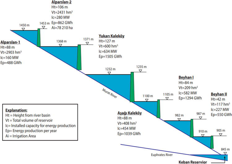
The Euphrates River has three main tributaries in the upper region of the basin: Karacasu, Perisuyu, and Murat rivers. The Keban dam lake is the confluence of these rivers. The Karacasu River is located further west and contains many large dams along with its other tributaries. The other main tributary, which is called as Perisuyu River, includes eight large dams called Kigi, Kalecik, Konaktepe, Ozluce, Pempelik, Seyrantepe, Tatar, and Uzuncayir. The third one is the Murat River, which originates in the northeast of Lake Van and flows westward, forming deep valleys to merge with the Karacasu tributary. There are 10 large dams which have been completed on this river and its tributaries including Ağrı-Yazıcı, Alparslan 1, Alparslan 2, Lower Kalekoy, Beyhan-I, Beyhan-II, Gayt, Gülbahar, Patnos, and Upper Kalekoy [13].
The 722-km Murat River originates from the north of Lake Van, flows toward the southwest, and reaches the Malazgirt Plain. This river receives other small tributaries in the Agri region on its way. After taking the Hinissu coming down from the Bingol Mountains, it enters the Mus Plain from the north by drawing hard geomorphologic features and taking the Karasu coming from Mount Nemrut here, then flows west, passing through narrow gorges and in front of Palu, merges with the Munzur-Peri water coming from the North, and immediately reaches the reservoir of Keban dam. The total hydraulic capacity is about 2650 MW. The dams and power plants with an installed capacity of 2149 MW have been planned on this river, and today more than 80% of them have been completed or are under construction. It is planned to irrigate about 120,000 ha of agricultural land in the region with the river’s water.
In this paper, the total risks of 10 above-mentioned dams on the Murat River will be examined, and their location within the cascade system will be evaluated. In particular, the effects of structures located in a cascade system will be focused on in terms of total risk related to upstream and downstream facilities and potential hazard situations expressed separately for each dam. The main physical characteristics of these dams, whose heights range from 36 m to 138 m from the river bed, are presented in Table 1. These dams were built to generate energy, to supply drinking water, and for irrigation usage. The dams located on the main river and built for electrical energy generation are privately owned. The related dams have been constructed in different types. Conventional types of dams (rock- and earth-fill) belong to the state. One-half of these dams were built by the state and the other half by the private sector. State dams are usually for irrigation purposes, while private dams are entirely for electrical energy generation (Table 1).
For the seismic analyses, seismic sources, which are acting on the investigation area, were identified and evaluated on the basis of guidelines and the hazard modeling developed for the region to form seismic model of the dam sites [14, 15]. The study of seismic activity includes both the Deterministic Seismic Hazard Analysis (DSHA) and the Probabilistic Seismic Hazard Analysis (PSHA) [16, 17]. Some attenuation relationships, which were developed on the basis of actual earthquake data, were adopted to obtain the peak ground acceleration (PGA) on each dam site, because of being no enough strong motion records. The analyses performed using the DAMHA software, which is a specified program, were developed in Osmangazi University. This program was used in several studies [18, 19, 20, 21, 22, 23, 24, 25, 26, 27, 28, 29, 30, 31, 32].
The recurrence interval of earthquakes was estimated as based on the seismic sources identified previously. The earthquakes that occurred within the last 100 years were used for estimating seismic parameters. Throughout the study, seismic zones and earthquakes within the area having a radius of 100 km around the dam site were considered. For all analyses throughout this study, the peak ground acceleration was obtained by considering FEMA’s earthquake definition by two methods [33].
Throughout this study, two methods have been considered for estimating the total risk for dam structures. In DSI guidelines, the total risk factor depends on reservoir capacity, height, evacuation requirement, and potential hazard [34]. The Bureau method, which considers the dam type, age, size, downstream damage potential, and evacuation requirements, was utilized to realize the risk analyses of the basin. It suggests four separate risk classes ranging from I (low risk) to IV (extreme risk) based on the total risk factor (TRF).
The area under investigation has a very complex geology and very active seismicity. The author of this paper and their colleagues introduce more comprehensive information about the geology and seismotectonic structure of the region [11, 12]. Two main energy sources are acting in the region: The North Anatolian Fault Zone (NAFZ) and The East Anatolian Fault Zone (DAFZ). The NAFZ is one of the best-known strike-slip faults in the world because of its significant seismic activity and well-developed surface features. It is approximately 1500 km long and extends from eastern Turkey in the east to Greece in the west. The width of NAFZ ranges from a single zone of a few hundred meters to multiple shear zones of 40 km. The DAFZ has a 550-km length and is a northeast-trending, sinistral strike-slip fault zone. It comprises a series of faults arranged parallel to the general trend. It is a transform fault forming parts of boundaries between the Anatolian and Arabian Plates [5].
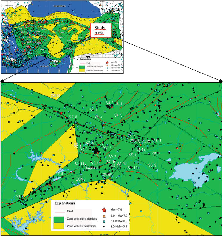
In this region, there are many earthquakes with a magnitude greater than 4.0 (based on the surface wave magnitude scale (Ms)), which indicates that the region is very active. Furthermore, there were only two earthquakes with a magnitude equal to or greater than 7.0 in the basin. The first one is the 1939 Erzincan earthquake with Ms of 7.9 and the second is the 1949 Karliova earthquake with Ms of 7.0. Earthquakes occurred in the region, and prevailing seismotectonic structures are given in Figure 1.
Figure 1.
Earthquakes on the seismotectonic model of the region.
For seismic hazard analyses of 10 dam sites, a detailed study was performed to identify all possible seismic sources based on the macro seismotectonic model of Turkey. The National Disaster Organization and other institutes prepared the map for general use. However, later it was modified by the author and his colleagues to be used for dam projects. The region’s seismic history and local geological features were used to quantify the rate of seismic activity in the basins. The seismic stability of dams considered in this study was re-analyzed according to the new map on seismic zonation and updated national regulations on seismic design. The results of seismic hazard analyses are given in Table 2.
Mmax = Maximum earthquake magnitude in Mw; Rmin = Minimum distance to fault segment; Mean PGA + 50% = Mean Peak Ground Acceleration at the 50th percentile; Mean PGA + 84% = Mean Peak Ground Acceleration at the 84th percentile.
OBE = Operational Based Earthquake; MDE = Maximum Design Earthquake; SEE = Safety Evaluation Earthquake.
The seismic hazard analyses performed using two different methods indicate that the PGA value varies within a wide range for the dam sites. The Deterministic Seismic Hazard Analysis (DSHA) shows that the PGA values for the 50 percentile range from 0.107 to 0.366 g, while those for the 84 percentile are between 0.174 and 0.596 g. According to Probabilistic Seismic Hazard Analysis (PSHA), peak ground acceleration (PGA) changes within a wide range for all earthquakes levels. These values mainly depend on the position of dam sites and the nature of predictive relationships. Beyhan-II dam has a PGA value of 0.872 g, which is the maximum value for all dams considered in this study based on the Safety Evaluation Earthquake (SEE). Beyhan-I and Yukarı Kalekoy dam sites will also be subjected to relatively high PGA values because of their proximity to the energy source. The sites of Gayt, Gülbahar, and Alparslan1 dams also pose high PGA values.
The results of total risk analyses are given in Table 3. The hazard ratio is very high for six dams and high for two, while two pose a moderate hazard ratio. According to ICOLD classification, all of them are categorized as a very high-risk ratio, except Patnos dam. This study shows total risk factor (TRF) values are between 136.2 and 204.4. The Bureau method indicates that all dams considered for this study are classified as high-risk ratios.
#
Dam
PGA in g
Mmax
Hazard Analysis
Total Risk (ICOLD,1989)
Total Risk (Bureau, 2003)
Class
Hazard Ratio
Risk factor
Risk class
Risk ratio
Risk factor
Risk class
Risk ratio
1
Agri-Yazici
0.175
6.6
II
Moderate
36
IV
Very high
136.2
III
High
2
Alparslan-1
0.422
6.4
IV
Very high
36
IV
Very high
148.2
III
High
3
Alparslan-2
0.319
6.4
III
High
36
IV
Very high
201.0
III
High
4
A.Kalekoy
0.323
6.4
III
High
36
IV
Very high
143.3
III
High
5
Beyhan-I
0.551
6.3
IV
Very high
36
IV
Very high
173.5
III
High
6
Beyhan-II
0.596
6.3
IV
Very high
36
IV
Very high
173.5
III
High
7
Gayt
0.491
6.5
IV
Very high
32
IV
Very high
204.4
III
High
8
Gulbahar
0.406
6.4
IV
Very high
34
IV
Very high
193.9
III
High
9
Patnos
0.174
6.3
II
Moderate
28
III
High
163.4
III
High
10
Y.Kalekoy
0.465
6.1
IV
Very high
36
IV
Very high
168.7
III
High
Table 3.
Total risk analyses of the dams considered for the study.
Within the scope of this study, the total risks of 10 dams constructed on the Murat River and its tributaries and their impact on the cascade system were examined. There are six large dams within the cascade system of the main river. These structures are Alparslan-1, Alparslan-2, Upper Kalekoy, Lower Kalekoy, Beyhan-I, and Beyhan-II dams, from the upstream and the downstream, respectively. The positions and energy levels of these dams within the cascading structure are presented in Figure 2. In addition to these dams, there are four separate large dams (Agri-Yazici, Gayt, Gulbahar, and Patnos) located on the tributaries of Murat River, which are embankment dams and have relatively low storage.
Figure 2.
The cascade system of Murat River of Euphrates-Tigris Basin [13].
The analyses indicate that Alparslan-1, Beyhan-I, Beyhan-II, and Upper Kalekoy dams, located in the cascading system, are under near fault motions. The relevant dams are 8.9, 3.0, 1.7, and 4.3 km away from the energy source, which can, on average, produce an earthquake of 6.4-moment magnitude (Mw) scale, respectively. Therefore, large PGA values appear in these dam sites, resulting in a hazard class with a “very high” ratio (Tables 2 and 3). These dams in the cascading system, with high total risk factors, are evaluated in detail below. Alparslan-1 and Lower Kalekoy dams, which are essential structures for the cascading system, are also included in this evaluation.
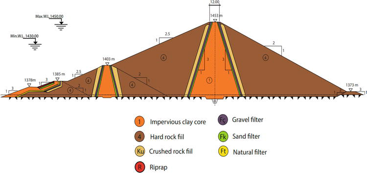
The Alpaslan-1 dam, which is the upmost structure in the cascade system of Murat River, is the most critical element according to failure scenarios. It was designed as the rock-fill type with an embankment body volume of 3.8 million m3 (Figure 3). Alparslan-1 dam has a height of 88 m from the river bed and a crest length of 571 m. Its total storage and active capacities are 2993 and 1743 hm3, respectively. The dam is under the impact of the near energy source. In other words, it is 8.9 km far away from the energy source, which can produce an earthquake of magnitude 6.4. The dam site poses a very high risk for all dams of the cascading system. This means that the overtopping problem will be seen in all the dams located downstream of the Alparslan-1 dam. The partial failure analyses indicate that a minor breach forms through the dam’s embankment. In complete failure scenarios of Alparslan-1, it is expected to have a large breach form in the embankment of the Alparslan-2 dam. In this context, considering the type of embankment material and foundation as well as the stability of valley slopes, a detailed geotechnical study should be carried out within the scope of the relevant dam safety program, and failure analyses should be conducted under different loading conditions using actual data for the foundation and embankment materials.
Figure 3.
The cross section of the Alparslan-1 dam [13].
Alparslan-2 dam, located within the cascade system and at the downstream side of Alparslan-1 Dam, has a significant storage capacity (2431 hm3). However, its storage capacity is smaller than that of the Alparslan-1 dam. This dam was designed as a rock-fill with an asphaltic core and the highest embankment on the Murat river (height from river bed = 108 m) with an embankment volume of 12.45 million m3. The dam site is not affected by the near-source zone, and the PGA values that will occur are relatively low. The dam site is 13.2 km away from the energy source zone, which could produce a magnitude 6.4 earthquake in Mw. The dam’s most significant source of hazard is large-scale damage or failure at the Alparslan-1 dam located upstream. Rather than measures to increase stability in the dam, construction measures should be taken to discharge the flooding resulting from the Alparslan-1 dam. For this purpose, the discharge capacity of the spillway can be increased, and/or additional spillway discharge capacity is created. This kind of study will be conducted for the first time in the country. Therefore, detailed evaluations should be made within the framework of the national dam safety program. It is a well-known fact that there can be some drawbacks to the private sector’s owning a dam for a certain period of time. This is an essential factor that may effectively take additional construction measures that may be necessary to be done in the project.
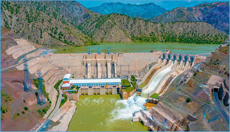
The Upper Kalekoy dam is the highest dam in the cascade system of Murat River (127 m in height from the river bed) and was designed as the type of roller-compacted concrete dam (Figure 4). Its maximum storage volume is 784 hm3, and there are three separate dams (Aşağı Kalekoy, Beyhan-I, and Beyhan-II) built with a lower capacity and a rigid type on its downstream. The dam site has the highest earthquake hazard in the cascade system, which is 4.3 km away from the energy source zone, capable of producing a magnitude of 6.1 earthquakes in Mw. The dam body will be able to work as a submerged structure during an overtopping event resulting from a large flood flow that may occur at the upstream.
Figure 4.
A general view from the Upper Kalekoy Dam.
The Lower Kalekoy dam, which has a height of 88 m from the river bed and a storage capacity of 517 hm3 at maximum water level, is built as a concrete-type downstream of the Upper Kalekoy dam. The dam site is located 12.7 km away from an energy source zone that could produce an earthquake with a magnitude 6.4 in Mw. Therefore, it has a lower risk of exposure to peak ground acceleration (PGA) than others located upstream and downstream. The dam body can be operated as a submerged structure during an overtopping event.
Beyhan-I dam, having a height of 84 m measured from the river bed and a storage of 369 hm3 at the maximum water level, is located between Lower Kalekoy and Beyhan-II dams and designed as a roller-compacted concrete dam. The dam site is under the impact of the near-field motion. The dam location is 3.0 km away from the fault zone, which could produce an earthquake with a magnitude of 6.3 in Mw. It would be subjected to the high PGA value (0.551 g) that may occur from the respective source. The dam body will be able to act as an overall spillway during considerable flooding by dam failure on its upstream.
Beyhan-II dam is the structure with the lowest height from the river bed (42 m) and the lowest storage capacity (79 hm3) on the cascade system of Murat River. The dam site is also the closest to the energy source (1.7 km), which can produce an earthquake with a magnitude of 6.3. Therefore, the dam site’s largest PGA values were obtained in the deterministic and probabilistic seismic hazard analyses conducted within the scope of this study. This dam body, a built-in concrete gravity type, will be able to perform as a submerged structure while an overtopping event occurs during considerable flooding resulting from dam failure downstream.
The cascade system with six large dams on the Murat River merges with the Keban dam reservoir located on the main Euphrates river. Keban dam is the second largest storage dam in the country, with a storage capacity of 31,000 hm3. The largest catastrophic failure that may occur in the cascade system of Murat River can be met by the huge capacity of the Keban dam when operated with an appropriate program. However, it is necessary to lower the normal water level (NWL) of the Keban dam reservoir by 3 m in terms of the system’s reliability.
The reliability of a cascade dam system depends on the type and storage capacity of each dam structure included in the system. In other words, the total risk of a dam located in a cascade structure and a singular dam located on a river is not the same. The total risk classifications used for this purpose do not take into account this difference and even suggest lower risk values related to the evacuation requirement and damage rate that may occur downstream. The hazard can be more due to the triggering phenomena for a significant catastrophic failure on the cascade system upstream. In reality, the total risk is several times greater than that estimated by risk classification.
Among the dams located in the Murat river cascade system, the maximal total risk belongs to the Alparslan-1 and Alparslan-2 dams, built in the embankment type and located at the most upstream part of the system. All design and construction measures to enhance safety should be taken for the Alparslan-1 dam, and the necessary observations and measurements should be carried out sensitively. The author introduces that a specific operation program should be prepared for this dam reservoir and operated by experienced engineers and technicians. For the Alparslan-2 dam, which is of the rock-fill type with a central asphalt core, construction measures should be taken to prevent overtopping phenomena and/or reduce its impacts. One of the considerations is to increase the discharge capacities of the existing dam system by using additional spillways/spillways to be constructed during the operation stage.
The most important advantage of the cascade system is that rigid dams can work as an overall spillway during overtopping. However, this issue is not considered in assessing the total risk analysis methods. It is appropriate to make a specific renovation to the cascade system in these methods. All of the dams involved in the study, except two separate dams mentioned above, are built in a rigid dam type, and the entire body can operate as a spillway during significant flooding. This is one of the most important advantages of the cascade system of Murat River. Another important advantage is a Keban dam with a huge storage capacity located downstream of the system. However, it would be appropriate to withdraw the normal water level to the elevation of 842 m for the Keban dam. This will also improve the safety of the dam, which is 48 years old and is of the composite type.
References
1.ICOLD. Selecting Parameters for Large Dams-Guidelines and Recommendations. ICOLD Committee on Seismic Aspects of Large Dams. Bulletin 72. 1989
2.Bureau GJ. In: Chenh WF, Scawthorn C, editors. Dams and Appurtenant Facilities in Earthquake Engineering Handbook. Bora Raton: CRS Press; 2003. pp. 26.1-26.47
3.ICOLD. Selecting Seismic Parameters for Large Dams-Guidelines. ICOLD, Bulletin 148, 2016
4.Tosun H. Seismic studies. International Water Power & Dam Construction. 2006;58(2):20-23
5.Tosun H, Zorluer I, Orhan A, Seyrek E, Savaş H, Türköz M. Seismic hazard and total risk analyses for large dams in Euphrates basin, Turkey. Engineering Geology. 2007;89(1-2):155-170
6.Tosun H. Total risk analysis of dam and appurtenant structures in a basin and a case study. International Congress in River Basin Management. 2007;I:477-488
7.Tosun H, Türkoz M, Savas H. River basin risk analysis. Int. Water Power and Dam Construction. May issue; 2007
8.Tosun H. Evaluating earthquake safety for large dams in Southeast Turkey. Hydro Review Worldwide (HRW). 2008:34-40
9.Tosun H. Re-analysis of Ataturk Dam under Ground Shaking by Finite Element Models. In: Proceeding of CDA Annual Conference. Saskatoon, Canada. 2011
10.Tosun H. Earthquake Safety of Keban Dam, Turkey. In: Proceeding of CDA Annual Conference. Fredericton, NB, Canada; 2012
11.Tosun H, Oguz S. Stability Analysis of Atatürk dam, Turkey as Based on the Updated Seismic Data and Design Code. In: Proceeding of 85th Annual Meeting of International Commission on Large Dams, Prague, 66-66, 2017
12.Tosun H and Oguz S. Seismic Design for Existing Large Dams and Case Studies. In: Proceeding of 11th ICOLD European Club Symposium Chania, Crete. 2019
13.DSI. Dams of Turkey. TR-COLD, Ankara, 2016602 p
14.Fraser WA, Howard JK. Guidelines for Use of the Consequence-Hazard matrix and Selection of Ground Motion Parameters. Technical Publication, Department of Water Resources. Division of Safety of Dams. 2002
15.Jiminez MJ, Giardini D, Grünthal G. Unified Seismic Hazard Modelling throughout the Mediterranean Region. Bolettino di Geofisica Teorica ed Applicata. 2001;42(1-2):3-18
17.Krinitzsky E. Discussion on Problems in the Application of the SSHAC Probability Method for Assessing Earthquake Hazards at Swiss nuclear power plants. Engineering Geology. 2005;82:62-68
18.Tosun H, Seyrek E. Total risk analyses for large dams in Kizilirmak basin, Turkey. Natural Hazards and Earth System Sciences. 2010;10(5):979
19.Seyrek E, Tosun H. Deterministic approach to the seismic hazard of dam sites in Kızılırmak basin, Turkey. Natural Hazards. 2011;59(2):787
20.Seyrek E, Tosun H. Influence of analysis methods for seismic hazard on total risk of large concrete dams in Turkey. Gazi Univ, J.Fac Engineering Architecture. 2013;28:67-75
21.Tosun H. Earthquakes and dams. In: Moustafa A, editor. Earthquake Engineering—From Engineering Seismology to Optimal Seismic Design of Engineering Structures. London: IntechOpen; 2015. DOI: 10.5772/59372
22.Tosun VT, Tosun H. Total Risk and seismic hazard analyses of large dams in Northwest Anatolia, Turkey. In: Proceeding of 85th Annual Meeting of International Commission on Large Dams. Prague. 2017. pp. 165-165
23.Tosun H. Safety assessment of large reservoir constructed for domestic water near urban areas and a case study. In: Proceeding of ICOLD-ATCOLD Symposium on Hydro Engineering, Wien. 2018. pp. 917-927
24.Tosun H. Stability analysis of large embankment dams located on shear zones and case studies. Hydrovision International. Colorado Convention Center. 2017
25.Tosun H, Tosun VT. dynamic analysis of embankment dams under strong seismic excitation and a case study. In: Proceeding of Long-Term Behaviour and Environmentally Friendly Rehabilitation Technologies of Dams (LTBD 2017). 2017. DOI: 10.3217/978-3-85125-564-5-102
26.Tosun H. Seismic stability of large dams located near energy source and a case study. In: Proceeding of 5th International Conference on Earthquake Engineering and Seismology, METU-Ankara. 2019
27.Tosun H. Earthquake safety evaluation for large dams located near the energy source and case studies. In: Proceeding of 11th ICOLD Europen Club Symposium. Chania. 2019
28.Tosun H. Hazard and total risk analyses of large dams under threat of the north anatolian fault zone in Mid-Anatolia, Turkey. In: Proceeding of 5th World Congress on Civil, Structural, and Environmental Engineering (CSEE'20) Virtual Conference. 2020. DOI: 10.11159/icgre20.191
29.Tosun H, Tosun VT, Hariri-Ardebili MA. Total risk and seismic hazard analysis of large embankment dams: Case study of Northwest Anatolia, Turkey. Life Cycle Reliability and Safety Engineering. 2020;1-10. DOI: 10.1007/s41872-020-00113-4
30.Tosun H. Experience on earthquake safety of large embankment dams constructed in Turkey. In: Proceedings of the 6rd International Conference on Civil Structural and Transportation Engineering (ICCSTE ’21). Virtual Conference. 2021. pp. 1-8 (addition). DOI: 10.11159/iccste21.137
31.Tosun H. Total risk and seismic stability of existing large CFRD’s in Turkey. In: Proceedings of the 6rd International Conference on Civil Structural and Transportation Engineering (ICCSTE ’21)Virtual Conference. 2021. DOI: 10.11159/iccste21.138
32.Tosun H. Dynamic stability of large embankment dams and a case study. In: Proceedings of the 6rd International Conference on Civil Structural and Transportation Engineering (ICCSTE ’21). Virtual Conference. 2021. DOI: 10.11159/iccste21.139
33.FEMA. Federal Guidelines for Dam Safety—Earthquake Analyses and Design of Dams. 2005
34.DSI. Selection of Seismic Parameters for Dam Design. State Hydraulic Works. Ankara. 29 p, 2012 (in Turkish)
Written By
Hasan Tosun
Submitted: 19 April 2022Reviewed: 21 April 2022Published: 07 June 2022
 Open access peer-reviewed chapter