 Open access peer-reviewed chapter

Abstract
An important part of the migratory population of european waterfowl, uses Spanish wetlands during their migratory trips and/or winter periods. In Spain, resident and breeding birds of this group, are important due to its number and some endangered species. Current populations have suffered a great decline since the middle of the last century, attributed, among other reasons, to the loss in number and quality of national wetlands. An area located in the center of Spain has been selected: a large plain called “La Mancha”. The number of lagoons, different ecological types and the “tablas” or river overflows, have constituted the values to be recognized as one of the most important Ramsar sites in Europe, and a Biosphere Reserve. Evolution have been studied, due to natural causes and human actions: trying to eradicate malaria and “recovering” land for agriculture, draining it through canals, ditches and wells, using it as landfill for solid waste and fecal and industrial water, and the extraction of water from undergroundb aquifers. These actions have destroyed, forever, 80% of the wetlands in this area. The effects on the associated fauna have been direct: its disappearance. The author is a direct witness to the development state of these wetlands over the last 50 years (1972-2023).
Keywords
- wetlands
- Mancha Húmeda
- Castilla-La Mancha
- waterfowl
- drainage
- aquifer
1. Introduction
Talking about wetlands in Spain might seem incongruous to the inhabitants of neighboring European countries and even to the majority of Spaniards themselves. The image of a country with many sunny days and relatively few rainy days does not invite to imagine large flocks of ducks or waders crossing the sky, feeding on the mud of shores or diving in a lagoon. That’s how it was and is, but the description of “large flocks” belongs to the past, sadly.
Since ancient times, man has considered wetlands as gloomy places and emanating miasmas, “putrid odor” and “bad vapors.” Spain has not been an exception, with abundant examples.
At the beginning of the nineteenth century (and several centuries before, but without sufficient means), civil engineers began to plan and execute sanitation works that especially affected those wetlands located in the vicinity of villages. The direct relationship of malaria with thousands of human deaths over the years cannot be denied, mainly in settlements located in the vicinity of flooded areas, some of these populations having to be completely abandoned. What makes these drying measures understandable [1, 2].
Malaria was considered endemic in Spain until 1964. Improvements in the knowledge of the disease, hygienic and sanitary conditions of the population, and medication, led the WHO to declare malaria eradicated throughout the national territory [3, 4].
Decisions to drain lagoons and channel rivers were not only motivated by the responsibility of governments, interested in alleviating diseases in the population; they also lobbied farmers’ interests, claiming crop losses due to flooding in flood cycles. In addition, there was interest in occupying the dried-up land that promised to be very fertile. It was not in most cases, since they turned out to be areas with high salinity, making the emerged lands unproductive for cultivation. On the other hand, if the drying up was sponsored by an individual, the State grant him the exploitation of the dried-up land for 99 years [5, 6, 7, 8].
According to data from the Ramsar Convention Bureau, since 1700 almost 90% of the world’s wetlands have been lost. During the twentieth century alone, the global extent of wetlands decreased by 64–71%. Between 1970 and 2015 the reduction was 35% (three times higher than the loss of forests) [9].
In Spain, most of the natural wetlands that disappeared until the 1960s and 1970s were drained and transformed, fundamentally, for agricultural use. It is estimated that, at that time, between 60% and 70% of the original surface had already disappeared. Between the years 1948 and 1990, a loss of 60% is calculated. These figures are similar to those from other countries in our socioeconomic style [10, 11].
Wetlands have been continually threatened and destroyed in Spain, throughout Europe... throughout the world.
This chapter reveals some of the wetlands that existed and were lost for different reasons. It does not forget the treatment that the wetlands of Castilla-La Mancha have received in the past and even in recent times. A summarized follow-up of the evolution of the existing ones is carried out. At the same time, it suggests recommendations considered important and basic, when recovering wetlands or creating new artificial lagoons.
The intention is not to raise wounds, some bad or never healed. It is intended, without harshness, to relate and analyze some of the mistakes that were made at certain moments in the past, trying to amend them in the present and avoid them in the future.
It is fair to recognize that, at present, interest in the conservation of wetlands is infinitely greater on the part of the general public, researchers and officials of the Administration of Castilla-La Mancha and Spain, with very notable compromise examples (Figures 1 and 2).
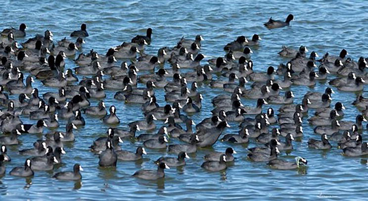
Figure 1.
Winter flock of coots (Fulica atra). Photo A. Amor.
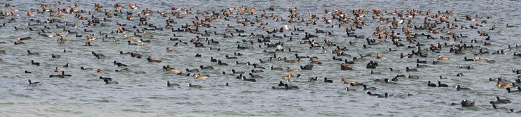
Figure 2.
Winter flock of red-crested pochard (Netta rufina) and coots (Fulica atra). Photo L. Basanta.
2. The geographical space of Castilla-La Mancha
2.1 La Mancha húmeda
Castilla-La Mancha is a region located in the center of Spain, politically called the Autonomous Community. It is made up of five provinces: Albacete, Ciudad Real, Cuenca, Guadalajara and Toledo. It is the third largest Spanish region. It occupies an area of 79,409 km2, with well-differentiated plains and mountains. It represents 15.7% of the Spanish territory [12, 13].
Wetlands of Castilla-La Mancha are located, generally, in areas of little pronounced reliefs. In fact, a large part of the region is a plain, a plateau, which constitutes the region called La Mancha. In the center of La Mancha, there is an area that borders four provinces (Albacete, Ciudad Real, Cuenca and Toledo) and is called “La Mancha Húmeda.” It is located at the Upper Guadiana River Basin and the southern area of the southern plateau or sub-plateau. Wetlands of this area can be classified as endorheic lagoons, outcrops due to contributions from the underground aquifer and overflowing rivers (tablas)1 (Figure 3) [12, 13].

Figure 3.
Location of Castilla- La Mancha region at Spain and Europe. Cartography Service. Junta CLM.
Some studies define lagoons of endorheic origin as: “... slight depressions in the ground that receive runoff water from the surrounding land during the rainy season, spring and autumn, sometimes very abundant, with torrential episodes affecting small areas. Its permanence depends on depth and environmental temperature of each season”. A short and precise definition with which it is agreed [7, 14].
La Mancha is the widest and most perfect plain in the entire Iberian Peninsula. It is a sedimentary basin in which the Guadiana River and its tributaries have not been embedded. Its altitude oscillates between 600 and 700 meters. It has a triangular shape: with a vertex in Ciudad Real capital. It opens toward the east, extending through the provinces of Albacete, Toledo and Cuenca [15].
Rivers that cross these areas do so already in their middle course. When they were, flowing their course was slow and lazy, zigzagging and rambling, which caused the surrounding land to flood due to overflow, since the channels were shallow and had to evacuate large volumes of water in a timely manner, coinciding with moments of copious rain sudden and brief. The water, which was circulating at low speed through the beds of these rivers, gradually were infiltrated into the ground, recharging the aquifers. In some sections of the route, due to the existence of torcas and sinkholes, surface water recharged the underground aquifers. Today they still perform their functions... when there is water [7, 11, 16].
There were also outcroppings of subsoil water, called in the area “eyes” which, by themselves, formed lagoons, collaborated in their genesis and made contributions to the fluvial “tablas”. They have been left off the hook due to the overexploitation of aquifers for agricultural irrigation [11, 14, 17].
2.2 The weather of La Mancha Húmeda
The Autonomous Community of Castilla-La Mancha presents a climate of contrasts, especially in its central zone, where La Mancha is located.
The climate of La Mancha Húmeda is continental and Mediterranean, characterized by an average rainfall of about 400 mm per year, with a record of temperatures that vary from −15 to 40°C, depending on the time of year [12, 13].
La Mancha is the largest plain in Spain. In contrast to secular dryland crops, it is an area with a relatively high number of endorheic lagoons (many of which have disappeared or are not operational), others marginal to the riverbeds of the rivers that cross the plain, as well as fluvial “tablas” in “La Junta de los ríos” Záncara and Gigüela, Tablas de Villarta and Arenas de San Juan, Tablas de Villarrubia de los Ojos and Tablas de Daimiel [14, 15, 17, 18].
This area marks low rainfall, between 300 and 500 mm/year. Without a defined periodicity, local storms with heavy punctual precipitation occur. They come to cause flooding and significant damage to populations, crops and lagoons in the area. The slope of the land, almost imperceptible, favors the permanence of the waters in the form of lagoons and “tablas.”
3. The international importance of La Mancha Húmeda
3.1 Recognitions and figures of protection
The international interest on the wetlands of La Mancha Húmeda has always been motivated by the functions they fulfill in the migration and wintering of european birds, especially for the ducks and waders groups. This is a proven reality [10, 11, 19, 20].
From the first moments, when the European conservationist and scientific associations began to organize and unite (MAR 1960 Project), the Spanish wetlands have been present at the top of the lists of priority areas for conservation. At the 1962 meeting of the MAR Project, in Saintes Marie de la Mer (France), the organizing entities IUCN, ICBP and IWRB declared several Spanish wetlands in Category A. (The reference to the wetlands of Castilla-La Mancha, called Castilla La Nueva in those years, is reproduced verbatim, in the original language).
“ESPAGNE (voir carte n° 8, page 100). CATÉGORIE A…..
La Mancha Húmeda was declared a Biosphere Reserve by UNESCO in February 1981. The numerous and continuous attacks on the wetlands, including Las Tablas de Daimiel National Park itself, led in 2007 to the proposal to declassify it as a Reserve. of the Biosphere, which was halted based on some commitments, partially fulfilled, although they have not given the expected results.
In the list of the Ramsar Convention for the year 2023, there are 76 Spanish wetlands registered, of which 8 belong to Castilla-La Mancha (Figures 4 and 5).
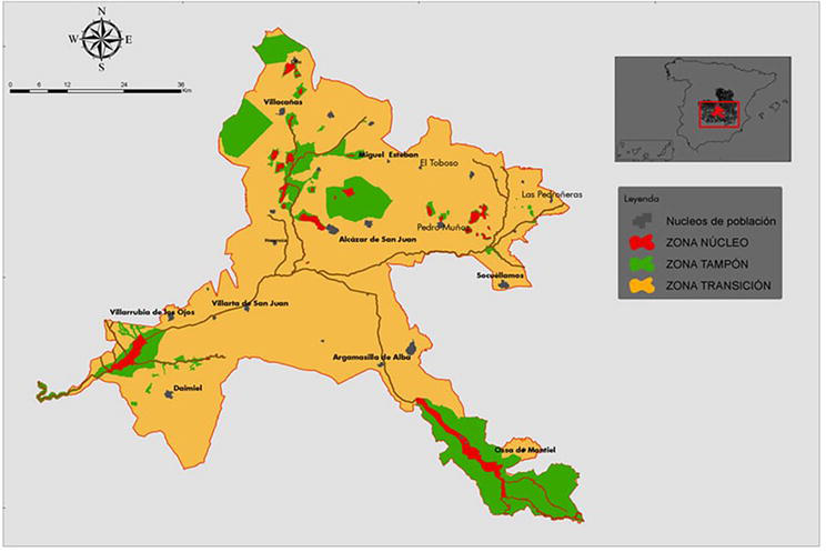
Figure 4.
Location of the La Mancha Húmeda Biosphere Reserve. Cartography Service. Junta CLM.
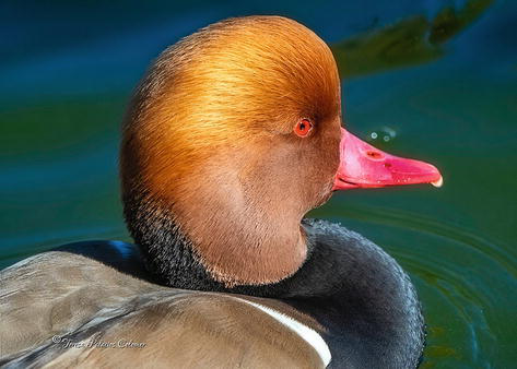
Figure 5.
Red-crested pochard, male (Netta rufina). Photo T. Palacios.
3.2 The war of quantities
The wetlands extension of La Mancha Húmeda has been the subject of various calculations, “grosso modo,” none of them match exactly. In addition to being for self-serving reasons in some cases, in others the variations in the figures could be due to the different areas visited or treated, and not explained in detail in the reports.
The Law of July 17th, 1956 on Cleaning up and colonization of swampy lands that extend immediately to the banks of the Guadiana, Cigüela, Záncara rivers and tributaries of the latter two in the provinces of Ciudad Real, Toledo and Cuenca, it refers in its Preamble “...with an approximate extension of 30,000 Ha. ...and that, through the execution of channeling works and the complementary desiccation, could be rescued for agricultural cultivation and destined to carry out colonization work in them...” [8].
Measurement calculations of the Ministry of Public Works itself, cited in its Projects for the drying of “unproductive” land in favor of agriculture, has been considered valid. It does not seem that this Organism, traditionally contrary to conservationist theses, was going to give incorrect figures on the extension of the land to be “recovered,” at least not upwards. The destructive fever, translated into drainage and desiccation, had endorsed the idea that flooding was unhealthy and unproductive areas that had to be cleaned up and recovered.
If, in 1956, 30,000 hectares of wetlands were estimated in different sections of the rivers and their surroundings, it does not seem unreasonable to calculate that there could have been more than 50,000 hectares that still existed in the 19th century.
The studies of this area, carried out in 1972 [21, 22], mention the existence of 20,000 Ha. (of vegas, tablas and flood plains). These areas stretched along the Riansares and Gigüela Rivers, highlighting for their extension the vegas and plains that were defined after the confluence of both rivers and that extended through Herencia, Villarta de San Juan, Arenas de San Juan and Villarrubia of the Eyes until reaching the Tablas of Daimiel [19]. In addition to the Tablas de Daimiel, a large concentration of wetlands of diverse types and genesis was located along this route: lagoons, extensive overflows of “tablas” rivers, upwellings, flooded lands, etc. [19, 21, 22], so it could be considered a mere rough estimate [7].
On November 29, 1994, in the interpellation of a Senator in the Plenary Session of the Senate, the figure of 32,000 Ha was cited, not having been refuted in the response of the Minister of Agriculture, “about the policy measures. general and environmental that the Government will adopt as a matter of urgency to repair and seek solutions to the ecological deterioration that is affecting the Tablas de Daimiel National Park (Ciudad Real)” [23, 24].
3.3 The biosphere reserve of La Mancha Húmeda
La Mancha Húmeda was declared a Biosphere Reserve by UNESCO in February 1981, protecting a total area of 25,000 Ha of wetlands, in which a “fundamental” area of 6000 Ha is located. The numerous and continuous attacks to the wetlands, including the Las Tablas de Daimiel National Park itself, led to the proposal for declassification as a Biosphere Reserve in 2007. This proposal was paralyzed based on some commitments, partially fulfilled, although they have not given the expected results in terms of improving lagoons and the National Park [10, 11, 25, 26].
On June 12, 2014, the extension of the Biosphere Reserve was extended to 418,066.16 hectares. This enormous increase in area is due to the inclusion of “buffer zones,” “transition zones,” population centers, 3 ZEPA areas, 3 LIC, etc., without there being a real increase in the surface area of wetlands or effective actions for their conservation/recovery. “Paper holds everything,” the Biosphere Reserve is being expanded and it gives the impression that the surface of wetlands has increased when what has been done has been to include the complete municipal terms of those that have lagoons, ponds or wetlands regardless of their conservation status (Figure 6) [27, 28].
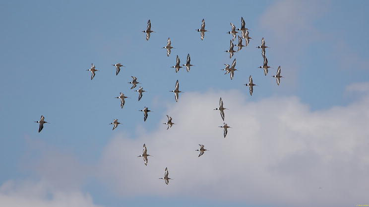
Figure 6.
Black-tailed Godwit (Limosa limosa) Photo F. Ochoa.
In the list of the Ramsar Convention for the year 2023, there are 76 Spanish wetlands registered, of which 8 belong to Castilla-La Mancha: Las Tablas de Daimiel National Park (Daimiel, Ciudad Real), Manjavacas lagoon (Mota del Cuervo, Cuenca), Lagoons de las Yeguas and Camino de Villafranca (Alcázar de San Juan, Ciudad Real), Lagoon of La Vega or del Pueblo (Pedro Muñoz, Ciudad Real), Lagoons of Puebla de Beleña (Guadalajara), Lagoons of Ruidera (Albacete and Ciudad Real), Prado lagoon (Pozuelo de Calatrava, Ciudad Real) and El Hito lagoon (El Hito, Cuenca) (Figure 7) [23, 24, 29, 30].
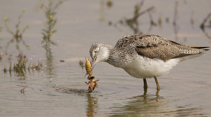
Figure 7.
Marsh Sandpiper (Tringa stagnatillis) feeding on a recent water pond. Photo F. Ochoa.
None of the 8 Ramsar sites, located in Castilla-La Mancha, are in an acceptable state of conservation: lack of water supply, clogging of the basin, planting of inappropriate plant species, appearance of invaders, insufficient or no wastewater supply, purified; beds contaminated by heavy metals, drainage ditches, pressure from tourism and leisure activities, very close aerodromes, etc.
4. Loss and degradation of wetlands at La Mancha Húmeda
4.1 General features
The actions on the Spanish wetlands and, specifically, on La Mancha Húmeda (what in current times we would call “environmental impacts”), have their origin from previous centuries, not only from the sixties. Drainage and channeling had already been carried out previously in order to prevent water from accumulating in “still” pools of water, the reason for the diseases and fevers that devastated entire populations (the role of mosquitoes was not yet known) transmission of malaria). Another reason for those past canalizations was to avoid flooding in times of flooding. Dozens of deaths occurred due to drowning, when the houses were flooded and crushed due to the collapse of the houses, since the water demolished the walls because they were built of tapial and adobes (blocks of mud and straw), like the vast majority of the houses in the time and area [1, 2, 3, 4].
In the last two centuries, the conversion of wetlands into agricultural land was widespread and incessant, throughout Spain. The actions carried out caused the loss, forever, of the “tablas” of La Mancha Húmeda, of the great lagoons of La Janda, Antela and Mar de Campos in northwestern Spain, and of a large part of the Guadalquivir marshes (Doñana), etc. [23]. The loss of wetlands in Spain between 1948 and 1990 has been calculated at 60% of those existing at the time [10].
It may seem that they are only talking about times past, or give the impression that with those enormous losses of wetlands, the fever for their destruction has ended. In La Mancha that never stopped…continue.
One hundred hectares, more or less, should not distract us from the lack of interest and responsibility that has been shown by the different Spanish organizations with competencies in the conservation of wetlands, deriving and prioritizing interests in only one direction: that of crops, agriculture, encouraging the extraction of water from aquifers with aid from the autonomous governments. Crops that are unthinkable in La Mancha have been planted such as corn, alfalfa and beetroot, which need enormous volumes of water, and must be irrigated by sprinklers, with higher temperatures in summer at 30–35°C, evaporating a large percentage.
With great sadness, we have witnessed, for several years, these risks of waste on the same border with the Las Tablas de Daimiel National Park. Park was dry and the sprinklers watering non-stop. The owners of these crops came to install a plate on the sprinklers that bordered the National Park, so that when they turned, none of the water would reach the Park land.
At the same time, wastewaters from any population near a lagoon have been dumped into the glass, as well as solid waste and even industrial wastewaters, with its load of heavy metals, oils and various chemical products (Figure 8).
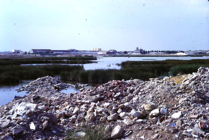
Figure 8.
Rubble dumped into a lagoon in 1990’s. Photo L. Basanta.
So, for too many years...
4.2 Agriculture: Priority of the destination of water. The irrigation
Let us focus on the recent past and the present: “the greatest pressures have been due, above all, to the intensification of agricultural activity: wetlands are no longer actively dried in a competition for soil resources, but water contributions are withdrawn that feed them in a competition for water resources; and also due to industrial development, infrastructure construction and urban developments related to the tourism sector” [31].
The Ministry for the Ecological Transition and the Demographic Challenge, in its “Strategic Plan for Wetlands to 2030” carries out, with objectivity and sincerity unusual in official publications, an in-depth diagnosis of the situation (2022) of the Spanish heritage of wetlands: “Up to practically In the 70s of the last century, the resource primarily demanded by the agricultural sector was soil, the availability of fertile and productive land, and for this reason many of our wetlands were drained and occupied, actions promoted by the legislative framework and subsidized by the administrations public. Currently it is the water resource” [10].
Before 1970, there were already irrigation systems in Spain that used water from subsoil aquifers. La Mancha was no exception. But those waters were obtained from shallow- or medium-depth wells, conditioned by the drilling machinery of that time. With limited flows, in turn, by the extraction motors that had to be exterior. The improvement of drilling equipment and, above all, the appearance of the submersible extractor pump, made the fever unleashed by irrigating and planting, the more the better, with subsoil water unbridled.
In 10 years, more than 130,000 hectares were irrigated, which meant an increase of four times the area traditionally irrigated until then [32].
In 1974, 152 hm3 was extracted and in 1987 it was 600 hm3. There was a drop in the water level, which implied the need to deepen most of the wells, the depletion of some and a long series of environmental implications causing the disappearance of surface water courses, the deterioration of water quality groundwater (infiltration of water drained from irrigated crops with high salt and nitrate content), the decrease in the degree of humidity of dryland soils and the disappearance of a large number of lagoons that made up the so-called Wet Spot [33].
The “New Water Law” 29/1985, of August 2, contained 9 transitory provisions and 7 additional ones. The transition period from the repealed Water Law of June 13, 1879, to the new one (3 years) was used to request, change, transfer, sell, titles, authorizations, etc., to extract water from aquifers.
During this period, the Basin Agency (Guadiana Hydrographic Confederation) received and authorized concessions for volumes that did not correspond to reality and were much higher than the real recharge capacity of the aquifer [34].
The situation spilled out of control: to the 16,000 legal catchments, we must add 22,000 unauthorized, illegal catchments, according to sources from the Guadiana Hydrographic Confederation itself [34].
The European Water Directive obliges river basin districts to act against the unrestrained pumping of groundwater masses, and sets a time limit: 2027 [33].
In 1985, the alarm had already been raised about the Las Tablas de Daimiel National Park [35]. It was not until February 1987 that the western La Mancha aquifer was declared overexploited [34].
Politicians from any party, neither national nor regional, have dared to put order in the uncontrolled opening of wells without a license, in the chaos of the excessive consumption of unauthorized flows.
Governments have not done enough to shut down illegal wells, fine offenders, and restore the ecological damage caused. Social protests, often violent, by farmers (See Section 4.3), scarcity of “water police,” sanctions for offenders are manifestly low…
There is much to do… (Figures 9 and 10).
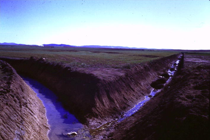
Figure 9.
Drainage ditches at the Turleque lagoon. 1988. Photo L. Basanta.
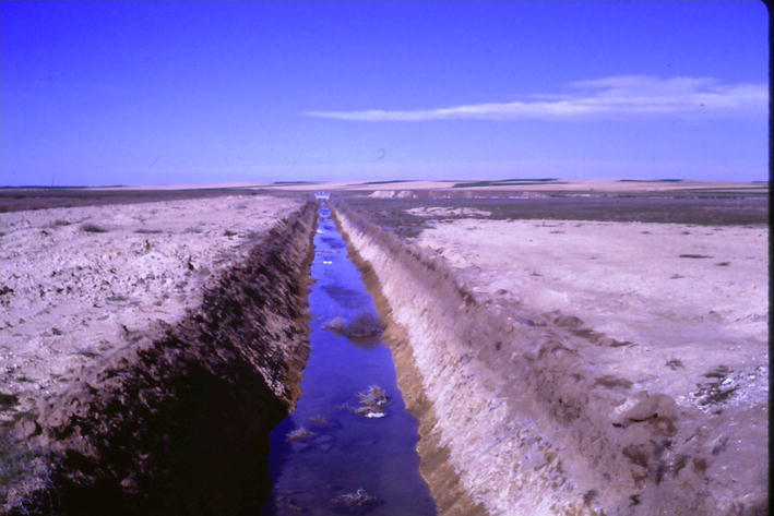
Figure 10.
Drainage ditch at the Camino de Villafranca lagoon. 1988. Photo L. Basanta.
4.3 Unfair actions derived from agricultural practices in wetlands
In full swing of protests by farmers over the declaration of overexploitation of aquifer 23 (Western Mancha), in February 1987, farmers in the affected areas held various assemblies to discuss their problems. In one of the meetings, held in Daimiel, a phrase was pronounced, well remembered by the few conservationists of that time: “water while there is water and then... the donkeys in the shade,” which seemed to express the general meaning of those assemblies (let us use the water until it runs out) without an iota of concern for the affected wetlands, nor for the one of greatest regional importance, located in the same municipal area: the Las Tablas de Daimiel National Park.
In March of the year 1988, one of the saddest events that we have experienced in the territory of La Mancha Húmeda took place. It happened during the filming of a series for Spanish Television entitled “España Húmeda.” On the 23rd we met with the management and the conservation team of the National Park in the Visitor Center, to schedule the day of the following day in which we were going to shoot inside the wetland. On March 24, at dawn, from the first high point of the road that leads to the National Park from the town of Daimiel, a dense cloud of smoke was observed that seemed to come from the very heart of the wetland. Unfortunately, it was so: the Daimiel Tablas were on fire!
It seems that some irresponsible people, informed of the presence of our Spanish Television team, tried, with this vandalistic, criminal act, to pressure and publicize their protests and demands. If you are capable of burning a National Park, you are capable of anything (Figure 11).
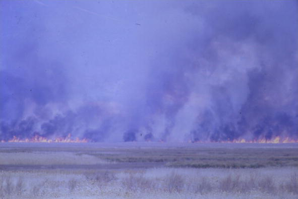
Figure 11.
Las Tablas de Daimiel National Park on fire. March,24th, 1988. Photo L. Basanta.
We did not transfer any images for news programs. The broadcast of the Series and the chapter on the National Park took place the following year, between January 3 and March 7, 1989.
It has already been mentioned above that there have been more than 22,000 illegal wells dug in La Mancha. No control of any kind. We have data, based on satellite images, which allow us to affirm that the extractions from the wells considered legal have also exceeded the capacities outlined in their authorizations. They have extracted much more water than authorized.
Another situation detected since the 1980s is that of the occupation of wetlands “by neglect.” It is a ladino practice that begins at the time when the shores, or even the entire wetland, are dry. The procedure consists of plowing the shores a few meters around the lagoon, year after year, little by little, each year a little more, until the “useful” surface of the lagoon is reduced, finally plowing the entire lake basin, literally erasing it, especially small- and medium-sized gaps [7, 10].
It is necessary to take into much greater consideration another silent problem that affects endorheic lagoons: Most of them are located in areas with a very little slope so that, due to runoff, it is not easy for them to receive sufficient contributions through scarce rains, because the streams do not begin to flow until the base soil of these small channels is soaked, except for specific cases of local downpours that discharge in their area of influence. These small channels have been modified or canceled in many cases. On this particularity are added the “managements” that some farmers carry out at the time of tillage, destroying or diverting the small and almost imperceptible channels, practically dry for many years, to level their land and gain a few square meters for cultivation [7].
Agricultural activities of diversion or elimination of small channels that flow into rivers or endorheic lagoons must be controlled. It is necessary to respect and recover them, in case they have been intercepted or destroyed.
4.4 Contamination by discharges
During the last three decades of the last century, and before, any lagoon close to a population was used as a dumping ground for contaminated water or solid waste. The less fortunate also received wastewater from the industrial estates: heavy metals deposited in the mud at the bottom, coming from paints and varnishes from door and furniture factories and other activities; debris and sewage in all of them. They were not treated in any way. They were just stored (Figure 12).
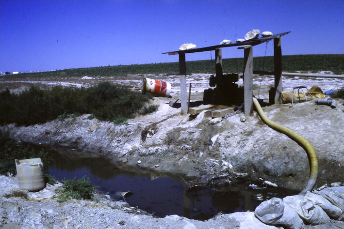
Figure 12.
Farmer irrigating with untreated wastewater, 1985. Photo L. Basanta.
Several of these lagoons had (and some still have) a level outfall, so that when the levels of water retained in the lagoon were excessive and threatened to affect cultivated land, the excess volume was evacuated directly, through a buried pipe that connected with the Riánsares or Gigüela Rivers, depending on the case, carrying the contaminated waters to the El Taray lagoon or to the Las Tablas de Daimiel National Park itself, downstream.
It coincided that these lagoons were, and still are, sources of botulism. Botulism foci have not disappeared from La Mancha Húmeda. In some wetlands, they are more vigilant than in others and proceed to dry out the lagoon as soon as they see the first affected birds, sending the effluent with some kind of pretreatment, in the best of cases, but always toward Daimiel.
4.5 Natural causes
In the territory of La Mancha Húmeda, the slight slope of the plateau contributes to a natural process in Geography such as the clogging of depressed areas in the endorheic lagoon areas, enormously sensitive to these processes, which ends with the disappearance of the lagoon as such, due to not being able to retain the water or because it does not reach the lagoon. In La Mancha Húmeda, there are striking examples of a phase close to disappearing as lagoons. For example, the Longar lagoon, in Lillo (Toledo), or the Manjavacas lagoon in Mota del Cuervo (Cuenca), etc. [7].
Few more natural causes can be mentioned, in which the human being has not intervened directly or indirectly.
5. Recovery and management of wetlands
The appearance of regional conservation associations at the end of the 1970–80s, and the increase in sensitivity toward wetlands on the part of the Regional Government of Castilla-La Mancha, led to the development of the first catalog of wetlands in the Autonomous Community, with the title “Catalog and Study on the Evolution and Ecology of the Wetlands of Castilla-La Mancha. Spain” 1989 [7].
Until then, wetlands only received the attention of waterfowl hunting enthusiasts. Lagoons such as La Albuera or El Escoplillo, in the municipality of Daimiel, very close to the National Park, are almost mythical names, which witnessed the numerous populations of aquatic birds that exchanged between it and the lagoons in its immediate surroundings and more far away, before they dried up due to being left hanging and without contact with the waters of the aquifer. They were run by the Alcyon Hunters Club (Figure 13).
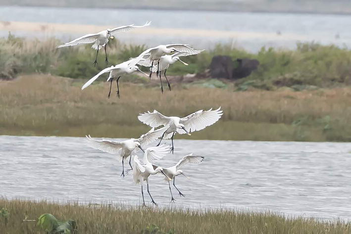
Figure 13.
Spoonbill flock (Platalea leucorodia). Photo A. Amor.
These same hunters recovered more than 2000 hectares of floodplains, turning them into artificial lagoons marginal to the Gigüela River, in the municipality of Quero, with strong private economic outlays in their construction and for hunting purposes, yes. It must be remembered that the first naturalist scientists in advanced countries were hunters. Notable figures in our conservation history were, too.
Few of these artificial lagoons remain operational. When Daimiel began to have serious problems due to lack of water, the Administration’s eyes were fixed on the private marginal lagoons of Quero, full of water. The year 1981 began when the first private lagoon was drained by deepening the channel of the Gigüela River and eliminating the water intake. It was the Arroyo Morón Lagoon, in which Biological Station we worked since 1976, until its desiccation.
In 1984, under the “disguise” of cleaning the Gigüela River bed so that the water from the transfer from the Tagus River reached the National Park through its bed, the water intakes of the El Taray lagoons were eliminated, El Masegar, Molino del Abogado, Vega de Quero, Vadoancho, Pastrana and Presarrubias.
The transferred water from the Tagus River barely reached the Park. The very bed of the Gigüela River, with numerous dolinas, filtered the water sending it to the aquifer.
The only wetlands in La Mancha Húmeda that conserved clean water, offered shelter to birds and allowed their reproduction to be successful had been eliminated. Our suggestion that the artificial lagoons of Quero were expropriated by the State, that hunting was prohibited in them, and that they were not drained, was ignored.
Of the “artificial” lagoons from that period, only El Taray remains and, much less extensive than the original, in favorable years, El Masegar.
El Taray lagoon is an artificial, private lagoon. An example of good management and conservation. Hunting has not been done there for many years and photography is now allowed from observatories (Figure 14).
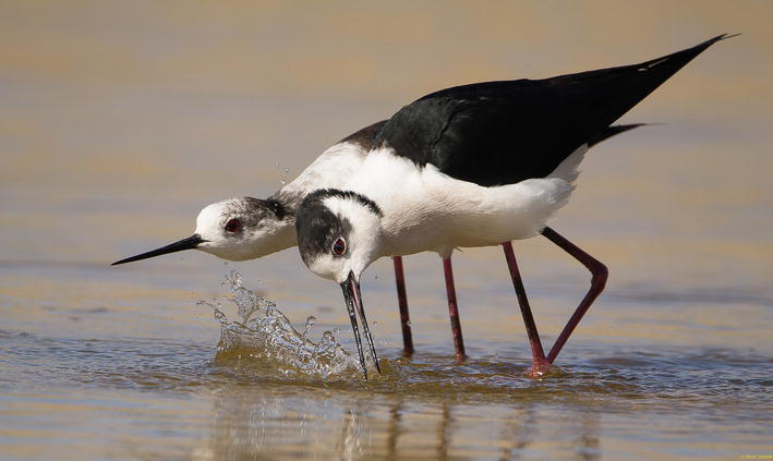
Figure 14.
Black-winged stilt (Himantopus himantopus). Photo F. Ochoa.
El Taray lagoon is maintained with water from the Riánsares River. Originally, they were “tablas” formed by the “junta” of the Gigüela and Riánsares Rivers. Dams were built more than a century ago to retain water and raise Carp (Cyprinus carpio
A conscientious study has concluded that the El Masegar lagoon and others in its immediate surroundings can be recovered if the natural functioning of the Gigüela River is restored, especially affected by the excavation and channeling of its channel [14]. This lagoon belonged to the José María Blanc Foundation, an entity of which we have been a part for several years, carrying out various studies on wetlands of La Mancha and Doñana.
Another artificial lagoon, privately owned, is the Dehesa Monreal lagoon, at the municipality of Dos Barrios (Toledo). Built with all the licenses, it is an example of good conservation management, although it was created at the end of the 1970s for the purpose of hunting. It is located on the banks of the Arroyo Cedrón. It has played a fundamental role in the recovery of Malvasía (Oxyura leucocephala) in Spain.
A municipal initiative that should be highlighted is the one that the City Council of La Guardia (Toledo) undertook in 2013 and 2015, acting on the reedbed adjacent to the Arroyo Cedrón (upstream of the Dehesa Monreal lagoons), to build three lagoons that have favored several species of endangered marsh birds, such as Bearded tit (Panurus biarmicus), Reed bunting (Emberiza schoeniclus) and Mustached warbler
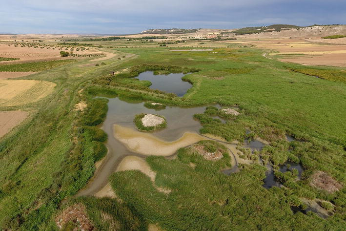
Figure 15.
Drone view. La Guardia (Toledo) lagoons. An initiative of the City Council and the Regional Government. Photo M. Guzmán.
In the most recent years, a certain interest in the recovery of some lost lagoons has begun. The interests are usually touristic, to attract visitors to the nearest city or town.
The so-called “recoveries” are not designed according to biological criteria: ornamental plant plantations are carried out and picnic tables are installed. Plant species such as Tamarix, a great detractor of water and an invasive species, have been introduced. The advisers, if there are any, have not known these wetlands in their best moments and repeat not very recommendable models of other equally incorrect recent actions.
A lagoon from La Mancha in 1972 did not have a row of tamarisk trees surrounding its perimeter. The lagoons of La Mancha, in general, did not have arboreal vegetation. In the recoveries, on many occasions, examples of design of artificial lagoons for hunting purposes have been followed.
We do not want to give here the names of affected lagoons. This is probably not the place to do it.
6. Current situation of wetlands at Castilla-La Mancha
In Castilla-La Mancha, it would be said that they have used their rivers for experimentation and example of drying theories. Thus, there is currently not a single important channel that crosses the plain of La Mancha that has not been “managed” by man.
Rivers Záncara, Gigüela, Guadiana, Valdespino, etc., have seen their sinuous paths become rectilinear channels.
The ecological disaster of these actions has been enormous: Several thousand hectares of rich marsh areas have disappeared forever and with them the animals that inhabited them, in such quantity and variety that they deserved international attention.
Lagoons have followed the same path and method. Those that were not filled with solid waste received wastewater and industrial discharges. In other cases, a ditch in its channel ended the life expectancy of aquatic fauna and flora.
Wetlands that survive in La Mancha go through greater difficulties every year. Those that are not dry are because they receive wastewater.
In the list of the Ramsar Convention for the year 2023, there are 76 Spanish wetlands registered, of which 8 belong to Castilla-La Mancha. This is the current situation.
Las Tablas de Daimiel National Park: Its natural functioning has been destroyed. There has been no “junta” of the waters of the Guadiana and Gigüela Rivers for more than 40 years. The flow of these rivers is a testimonial. The main cause of the limited state in which the National Park is located is the drop in the water level caused by the massive extraction of water from the aquifers for agricultural irrigation. Of the wells drilled, 2/3 are illegal, without a license. The National Park, with enormous difficulties, survives thanks to the work of guards and technicians, the transfers it receives from the Tajo River and the punctual contribution of water pumped from emergency wells, which allows having a minimum extension of open water to avoid the spontaneous combustion of peat, which is the main substrate of the National Park.
Laguna de Manjavacas (Mota del Cuervo. Cuenca): Traditionally it has been the best lagoon in La Mancha Húmeda to observe migrating waders, and, depending on the water level, to establish breeding colonies of Black-necked grebes (Podiceps nigricollis
) and various species of larolimicolae. It is in the final phase of clogging, accelerated by the continuous contribution of wastewater from the population of Mota del Cuervo for decades. It was a typical La Mancha endorheic lagoon, saline, with specialist vegetation on the shores (Suaeda sp. Salicornia sp. etc). For 30 years a reedbed has developed around the point of entry of wastewater, which undermines its original character. The Greater Flamingo (Phoenicopterus roseus) has come to reproduce. We suspect that these colony nestings have been induced by unscrupulous amateurs, who have built nest starts to provoke acceptance by the birds. Another serious mistake, if it had been so.Lagoons de las Yeguas and Camino de Villafranca (Alcázar de San Juan. Ciudad Real). Laguna de las Yeguas is hypersaline. Its state of conservation is relatively good. It is in danger of receiving contaminated water, as has already happened because it is connected to the Camino de Villafranca lagoon by means of a canal. This last lagoon has been the one that has received, for decades, untreated wastewater from the town of Alcázar de San Juan and its industrial park. These waters were so poisonous that in a few minutes, they rusted a piece of metal that was introduced into them. It has been completely emptied on different occasions. The contaminated water has been conducted through the La Veguilla canal to the Gigüela River and directly to the Las Tablas de Daimiel National Park. It currently receives water with a certain degree of treatment from the Alcázar de San Juan Treatment Plant, which is discharged right at the outlet of the treatment plant, forming the La Veguilla lagoon. They have always been dangerous lagoons because at the end of the summer, the botulism epidemic has always developed, with significant mortality of birds. In recent times, it has been decided to empty them of water as soon as the first dead birds appear and the water from the treatment plant is sent directly to the Gigüela riverbed.
Laguna de la Vega or del Pueblo (Pedro Muñoz. Ciudad Real). Lagoon of endorheic origin is highly polluted by contributions of wastewater from the village. It has always been a privileged lagoon for the reproduction of colonies of Black-necked Grebes and White-faced Terns (Chlidonias hybrida), Ducks and Common Pochards (Aythya ferina) and Black-headed Gulls, (Chroicocephalus ridibundus) despite the fact that it has always been affected by botulism. Currently, it dries up in some seasons to avoid mortality. The density of birds in the breeding season is impressive.
Lagoons of Puebla de Beleña (Puebla de Beleña, Guadalajara). Both are not located in La Mancha. In other times, with water, it housed an important colony of Black-necked grebes. Currently, the water level is at −1.20 m, according to two witness wells. Its state of conservation is very good, except for the lack of water and the proximity of an airfield.
Ruidera Lagoons (Ruidera, Argamasilla de Alba, Alhambra and Villahermosa. Ciudad Real) (Ossa de Montiel. Albacete). There are a total of 15 interconnected lagoons, through which the water that communicates them runs in stages. Those located at a lower altitude are the most interesting for birds. It is an area that suffers strong tourist and real estate pressure. The volumes of water have decreased notably due to irrigation located at the highest points.
Prado Lagoon (Pozuelo de Calatrava. Ciudad Real). It is of pseudokarstic and seasonal origin. It usually dries up in summer. Numerous pairs of Avocet (Recurvirostra avosetta) and Stilt (Himantopus himantopus
) reproduce. During the migratory period is visited by waders and in winter by ducks. It is located next to the population.Lagoon of El Hito (El Hito and Montalvo. Cuenca). It is an endorheic lagoon of 573 hectares in a good state of conservation. Its greatest importance is hosting large flocks of Cranes (Grus grus) on their autumn and spring migrations.
Spanish Inventory of Wetlands lists as existing lagoons that were dried up when the river intakes were eliminated. As an example, the Arroyo Morón lagoon is one of them. Dry since 1981. Other inaccuracies are due to the double annotation of the same lagoon basin with a different name but identical coordinates. It is a great job but still inaccurate.
The Ministry for the Ecological Transition and the Demographic Challenge has published a short report on the state of Ramsar wetlands in Spain: About 12% of the sites are well preserved, 15% is in a moderate state, 24% are in a poor state, 30% is in a very poor state and 19% are under evaluation.
“Among the inland aquatic environments, floodplains have suffered a greater degree of alteration, being entirely modified by man, followed by freshwater wetlands (62% modified), karsts (54%) and saline (51%). Mountain lakes and wetlands are those with the best state of conservation, as they have been less intervened. On the other hand, more than two thirds of the inventoried coastal wetlands are considered altered or degraded, while those that are conserved do not reach one third” [10].
7. Conclusion
This account of part of the history of the evolution of the wetlands of La Mancha leaves, once again, a strong bitter taste for some conservationists who saw the splendor of the “tablas” of Villarta and Arenas de San Juan in 1972, the “Junta” of the Záncara and Gigüela Rivers, and Las Tablas de Daimiel National Park in 1975, and up to the present 2023.
There has been no respect for wetlands or the National Park nor is there now. Very few concrete actions are carried out. It is almost better that way, because when they do one, are making mistakes of Conservation. Fortunately, nature always puts those who plant tamarisk trees around the shores of Lagoon X in their place, drying up the planted specimens.
Various villages close to lagoons have been equipped with treatment plants, but the water that is discharged into them is not always adequately purified. Sometimes due to breakdowns, other times due to lack of available budget, the treatment plant does not work. The quality of the effluents from the treatment plants is not always optimal, with untreated direct discharges being made into the beds of lagoons and rivers.
Now, the objective seems to be to demonstrate that we have a lot of protected territory. A set of figures and numbers in which the extension of wetlands is mixed with other uses, reaching surfaces that place us in third place in the world in Ramsar sites and first in Unesco Biosphere Reserves. Are really protected?
La Mancha Húmeda situation is so desperate that it calls for desperate measures.: ¡To each lagoon its well!. Conservation must fight with the same weapons as agriculture. The excavation of a well in the vicinity of a lagoon, and the provision of an extractor motor, would allow to control the adequate water levels. We must guarantee water in the lagoons in the most sensitive biological periods. The hatred toward wetlands seems to be carried in the blood and inherited. So many years and it seems that we have not learned anything. We are arriving too late…
Acknowledgments
We must acknowledge the vocational work in favor of La Mancha Húmeda wetlands by: José María Blanc, Francisco León, José Baragaño, Manuel Sáenz de Viedma, Francisco Bernis, Ramón Sáez-Royuela, Ramón Coronado, José Luis Oriol, Javier Castroviejo, Pedro Molina Vicente, Cosme Morillo, Germán García, Carlos Roquero, Ismael Riquelme, Carlos Otero, Fernando Portillo, Juan Rubio, Tom Gullick, Keith Emmerson, José Jiménez, Jesús Casas, Mª Jesús Sánchez, Manuel Carrasco, Carlos Ruiz, Antonio Aranda, Bautista García-Consuegra and his sons Bautista, Jesús and Prisco, Angel Clavería, Alejandro del Moral, Julio Escudero, Francisco Escudero, Hermanos Santos, Enrique Arias, Beltrán Ceballos, Carlos Llandres, Blanca Ramos, Raúl Martínez, Blanca Soto, Luis Rodríguez, José A. Basanta, Eduardo Castilla, Carlos Turón and his sons Carlos and Jorge, Antonio Carmena, Pablo Pereira, Javier Pasamontes, Enrique del Castillo, Macario the guardian of El Taray, Santiago Reino “El Pincha” and many others friends with whom we share birdingdays of waders and ducks, and to whom I apologize for not being reflected here. Thanks also to the photographers who have lent the photos for this chapter.
References
- 1.
González M, J.A. La desecación de humedales en los inicios del siglo XIX: un proyecto de ingenieros militares en La Mancha. Cuadernos de Geografía. 2022; 108-109 (1):149-173 Valencia (España) - 2.
Bertola M, Mazzucato M, Pombi M, et al. Updated occurrence and bionomics of potential malaria vectors in Europe: A systematic review (2000–2021). Parasites Vectors. 2022; 15 :88. DOI: 10.1186/s13071-022-05204-y - 3.
Tajuelo ML. El Paludismo en España desde una perspectiva histórica. Facultad de Farmacia. Universidad Complutense de Madrid; 2017. Available From: https://eprints.ucm.es/id/eprint/55457/ - 4.
https://lamalaria.com/malaria/malaria-espana/ . [Accessed: January 28, 2023] - 5.
Abellán Contreras, F.J. Consideraciones histórico-jurídicas sobre el saneamiento de terrenos pantanosos, lagunas y marismas en España (SS.XIX-XX): Exégesis de la «Ley Cambó». Revista Jurídica de Castilla y León, Núm. 58. Sept. 2022. ISSN: 2254-3805 - 6.
Gaceta de Madrid. Núm 208, 27 julio 1918. pp. 268-270. Ley Cambó - 7.
Basanta Reyes LF. Estudio Inventario sobre la Evolución y la Ecología de las Zonas Húmedas de Castilla-La Mancha (5 vols.). In: Dirección General de Montes, Caza y Pesca. Consejería de Agricultura. Toledo: Junta de Comunidades de Castilla-La Mancha; 1989 - 8.
Boletín Oficial del Estado. Ley sobre saneamiento y colonización de los terrenos pantanosos que se extienden inmediatos a las márgenes de los ríos Guadiana, Cigüela, Záncara y afluentes de estos dos últimos en las provincias de Ciudad Real, Toledo y Cuenca. Ley de 17 de julio de 1956. Madrid: B.O.E; 1956. Núm. 200. pp. 4693-4695 - 9.
https://www.ramsar.org/es . [Accessed: February 01, 2023]. - 10.
MITECO. Situación actual y perspectivas de conservación y restauración de los humedales españoles hasta 2030. Informe. Madrid: Ministerio para la Transición Ecológica y el Reto Demográfico; 2020 - 11.
Casado, S., Florín, M., Molla, S. & Montes, C. Current status of Spanish Wetlands, en Finlayson, M, Hollis, T. & Davis, T. (Eds) Managing Mediterranean wetlands and their birds. En Comunic. Comisión EU 1994. Actas del Simposio Internacional del IWRB de Grado, Italia, febrero de 1991. Publicación especial del IWRB n° 20, 1992, GB. Istituto Nazionale di Biologia della Selvaggina, Italia. Páginas 56-58. - 12.
https://www.castillalamancha.es/clm/geografia . [Accessed: March 2, 2023]. - 13.
Pérez González ME, Sanz Donaire JJ. Clima y microclima de La Mancha Húmeda. Anales de Geografía de la Universidad Complutense 1998; 18 : 239-256. ISSN: 0211-9803 Madrid. España - 14.
Fornés JM, de la Hera A, Cruces J, Llamas MR. Funcionamiento hidrológico de un humedal ribereño, El Masegar, en el conjunto de los humedales de La Mancha Húmeda de la Cuenca Alta del Río Cigüela. Estudios Geológicos. 1995; 51 :259-276 CSIC. Instituto de Geociencias. Madrid - 15.
Díaz Moreno JL, Sierra GJ, Vázquez González A, Zárate Martín A, de Castilla-La A, Mancha. Junta de Edita: Junta de Comunidades de Castilla-La Mancha. Toledo; 1986 - 16.
Basanta Reyes, L.F. Informe. Había una vez … Las zonas húmedas. Revista Añil (Cuadernos de Castilla-La Mancha) . 1993;2 :13-15. Toledo.https://www.researchgate.net/publication/344954030 - 17.
García Rodríguez M. Hidrogeología de las Tablas de Daimiel y de los Ojos del Guadiana. In: Bases hidrogeológicas para una clasificación funcional de humedales ribereños. Tesis Doctoral. UCM Madrid: Facultad de CC Geológicas; 1996 - 18.
López-Rey Lumbreras D. Riadas históricas en la provincia de Toledo. In: Análisis meteorológico e impacto social. Tesis de Lic. Madrid: UCM; 2007 - 19.
Madrazo B, Francisco. Información española sobre anátidas y fochas (Época invernal). Publicaciones de la Sociedad Española de Ornitología. 1964 - 20.
Olney PJS, the staff of the IWRB/MAR Bureau. IUCN Publications New Series. N°5. Sponsored by IUCN, ICBP and IWRB; 1965 - 21.
Club de Cazadores “ALCYON”. Nuevos datos sobre la nidificación de Larus ridibundus en España (region manchega). In: Volumen Especial. 459-471 . Ardeola, International Journal of Ornithology. Madrid: Sociedad Española de Ornitología; 1971 - 22.
Bernis Madrazo F, Compte Sart A. Informe sobre las Tablas de Daimiel y otras zonas húmedas manchegas. Informe inédito. 1972 - 23.
Martín Mateo, R. La protección de las zonas húmedas en el ordenamiento español. Revista de Administración Pública, 1981. pp. 7-31. Núm. 96. Septiembre-diciembre. Madrid. - 24.
Senado Cortes Generales. Diario de Sesiones del Senado V Legislatura. 1994. Núm. 56. Interpelación Parque Nacional de las Tablas de Daimiel (Ciudad Real) - 25.
https://www.ramsar.org/es/acerca-de/historia-de-la-convencion-sobre-los-humedales . [Accessed: March 7, 2023]. - 26.
Pérez M, Aramburu MJ, González JL. Reserva de la Biosfera de la Mancha Húmeda: retos y oportunidades de futuro. In: Dirección General de Áreas Protegidas y Biodiversidad. Toledo: JCCM; 2011 - 27.
https://www.castillalamancha.es/gobierno/desarrollosostenible/dgapfyen/actuaciones/reserva-de-la-biosfera-de-la-mancha-humeda [Accessed: February 2, 2023] - 28.
Barbier EB, Acreman MC, Knowler D. Valoración económica de los humedales – Guía para decisores y planificadores. Gland, Suiza: Oficina de la Convención de Ramsar; 1997 - 29.
UNESCO. Convention on Wetlands of International Importance Especially as Waterfowl Habitat. 1994. Irán: Ramsar; 1971 - 30.
SEO/BirdLife. In: SEO/BirdLife, editor. Humedales Ramsar en España: En Alerta. Madrid: SEO/BirdLife; 2022 - 31.
Viñals MJ, Blasco D, Morant M, editors. Los humedales mediterráneos: el contexto ambiental y social. In: Reflexiones para su estudio y gestión eficaz. Fundación Biodiversidad de la presente edición Editorial Universitat Politècnica de València; 2011. p. 266 - 32.
Sancho Comins J, García-Abad Alonso JJ, Navalpotro Jiménez P, Santaolalla A, Martínez Vega J. La tradición e innovación en el paisaje agrario: los efectos de la PAC en la región central española. El campo: boletín de información agraria , 1994. pp. 215-234. ISSN 0212-2146 - 33.
Rosell J, Viladomiu L. El Programa de Compensación de Rentas por reducción de regadíos en Mancha Occidental y Campo de Montiel. Miteco: Economía Agraria, n.° 179; 1997. pp. 331-350 - 34.
WWF/ADENA. 2006 Uso ilegal del agua en España. Causas, efectos y soluciones. info@wwf.es. [Accessed: February 4, 2023] - 35.
Basanta Reyes LF. Tablas de Daimiel: SOS. Castilla-La Mancha. Revista de Información de la Junta de Comunidades. 1985; Julio N° 17 :14-15 Toledo
Notes
- The Spanish word “tablas” appears numerous times throughout the text of this chapter, related to wetlands. At La Mancha Húmeda (Central Spain) terrain is very flat, rivers are in their middle course, are shallow and meandering. When the flow increases due to sudden rains, riverbeds are not able to evacuate and overflows occur (flood plains, “tablas”). River seems to widen and flow so slowly that water seems to stop, giving the image of a great plain of still water, so flat as a table or a board. Waters of these overflows usually remain for several weeks, creating a specific ecosystem of great ornithological richness. The best example in Spain was the Tablas de Daimiel National Park, currently with enormous problems to survive as an ecosystem.