Open Access is an initiative that aims to make scientific research freely available to all. To date our community has made over 100 million downloads. It’s based on principles of collaboration, unobstructed discovery, and, most importantly, scientific progression. As PhD students, we found it difficult to access the research we needed, so we decided to create a new Open Access publisher that levels the playing field for scientists across the world. How? By making research easy to access, and puts the academic needs of the researchers before the business interests of publishers.
We are a community of more than 103,000 authors and editors from 3,291 institutions spanning 160 countries, including Nobel Prize winners and some of the world’s most-cited researchers. Publishing on IntechOpen allows authors to earn citations and find new collaborators, meaning more people see your work not only from your own field of study, but from other related fields too.
To purchase hard copies of this book, please contact the representative in India:
CBS Publishers & Distributors Pvt. Ltd.
www.cbspd.com
|
customercare@cbspd.com
Analytical Hierarchy Process (AHP) one of the Multi-Criteria Evaluation techniques is proposed by Saaty’s-1980. More than one parameter is equally important for management, as these are very much interrelated. One of the methods is AHP, which is welcomed for supporting procedural justice that regards clearness and equality of decisions. However, the AHP method promises for procedural justice are partly grounded in it is supposed by numerical accuracy. By contrast, AHP method can contribute to the multiple criteria for procedural justice, which may explain AHP’s continuing and growing popularity. The actual process of applying the decision rule is evaluation. In order to meet a specific objective, several criteria need to be evaluated. Such a procedure is termed as AHP. The integration of special information technology and multi-criteria methods facilitate the provision of a tool with great potential for obtaining watershed boundary or selecting sites for taking action plan. AHP provides an appropriate framework for the application of multi-criteria evaluation methods, whereas multi-criteria evaluation techniques add to GIS the means of performing trade-offs on contradicting objectives, giving weight-age to both multiple criteria as well as the knowledge of the decision maker.
Geography in the Department of Pure and Applied Science, Midnapore City College, Midnapore, West Bengal, India
Jatisankar Bandyopadhyay
Department of Remote Sensing and GIS, Vidyasagar University, Midnapore, West Bengal, India
Pabitra Banik
Agricultural and Ecological Research Unit, Indian Statistical Institute, Kolkata, West Bengal, India
*Address all correspondence to: 1kbrsgis@gmail.com
1. Introduction
According to Thomas L. Saaty [1] “We are all fundamentally decision makers. Everything we do consciously or unconsciously is the result of some decision”. By the objectives, criteria, sub-criteria, alternatives multi-level hierarchical structure are used. Pair wise comparisons pertinent data set derived from pair wise comparison [2]. These pair wise comparisons are used to obtain the weights of rank of the decision criteria, and the relative performance measures of the alternatives in terms of each individual decision criterion. The mechanism improving is required if the comparisons are not perfectly consistent.
Analytical Hierarchy Process (AHP) one of the Multi-Criteria Evaluation techniques is proposed by Saaty’s-1980. The AHP is increasingly used as decision support method along with multiple parameters. AHP is welcomed for supporting procedural justice that regards clearness and equality of decisions. The numerical basis of AHP is not as unequivocal as current ‘AHP standard practice’ suggests. By contrast, AHP can contribute to the multiple criteria for procedural justice, which may explain AHP’s continuing and growing popularity. It is increasingly used as decision support method along with multiple parameters.
Many researches had been applied in several fields, for example, in engineering [3], industry [4], economics [5], environmental management, and water management [6, 7, 8, 9, 10].
Recently researchers have applied AHP to decision-making concerning water resource management [9, 11] focusing on criteria relating to social, economic [12], and environmental factors [13]. Thus, multi-criteria (or multi-parameters) decision support methods are widely applied in evaluation and strategic watershed planning and management, and infrastructure development. Multiple criteria analysis techniques have been used by water resource practitioners to select or to design alternatives in areas such as river basin planning and development, water resources development, land use management, groundwater/surface water allocation, watershed restoration and water resources quality [14, 15].
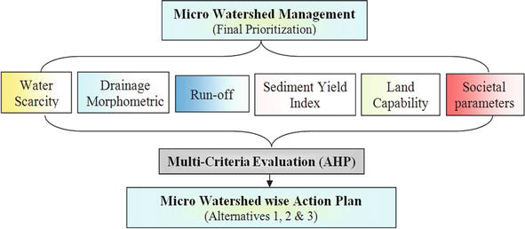
More than one parameter is equally importance for management [16], as this is very much interrelated. In the present study watershed management, 6 standard methods were used and studied briefly to calculate individual parameters of the study area. Final priority has been evaluated through AHP method [1]. This is useful for water resource management, with diverse malty parameter, for prioritization questions with diverse criteria or for allocation of scarce resources. However, AHP’s promises for procedural justice are partly grounded in its supposed numerical accuracy.
Insufficient of hydrologic data, the logical alternative is to use for estimate the hydrologic characteristics of a watershed by using drainage morphometric parameters. These parameters can be precisely estimated in GIS environment. Extensively used techniques for estimating direct runoff depths from storm rainfall proposed by United States Department of Agriculture (USDA) Soil Conservation Service’s (SCS) Curve Number (CN) method [17]. SYI model used for quantitative assessment of soil erosion which is basic aspect of watershed management, one can predict the amount of soil loss by using some empirical formulae. Also demographic stretcher information is required for best management practices on these areas and assessment of BMP implementation effectiveness on water amiability improvement through monitoring strategies. The final priority and action plan of each micro-watershed has been taken by Analytic Hierarchy Process (AHP) [18].
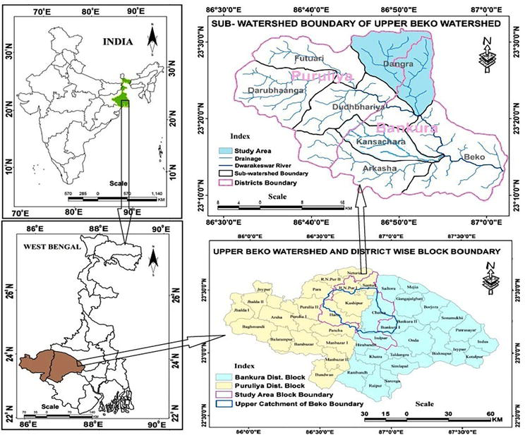
Dwarakeswar (also known as Dhalkishor) river originates from the Tilaboni hill near Bangalia Railway Station in Puruliya district of West Bengal state, flows easterward through pedimental landscape and enters into dissected Bankura, then enters in lateritic upland and further downstream into the Gangetic Alluvial Terrain debouching in the Rupnarayan river [19]. Beko is one of the watersheds of Dwarakeswar river in Bankura and Puruliya district. Upper Beko watershed (2A2C8) contains 7 sub-watersheds i.e. Beko, Dangra, Kansachara, Arkasa, Dudhbhariya, Darubhanga and Futuari (Figure 1). This study was undertaken in sub-watersheds namely Dangra (Figure 1).
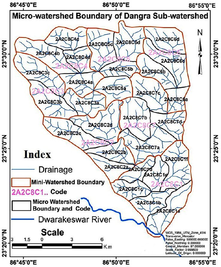
Left hand tributary of Dwarkeswar river flowing through Kasipur, Raghunathpur-I, & Santuri block of Puruliya district and Chhatna block in Bankura district. Dangra sub-watershed contain by proposed 29 micro-watersheds (Figure 2). The area of Dangra sub-watershed is 210.16 km2 and elevation varies between 90 m to 250 m above mean sea level (MSL).
Figure 2.
Study area watershed.
The area under study constitutes part of a semi-arid region with distinct characteristics in terms of the following elements i.e. Relief, Soil, Geology, Climate, Drainage, and Slope, Land use / Land cover and Groundwater availability.
Watershed management is described by the different natural parameters for tacking appropriate action plan or implementation. Watershed management is a complex attribute of watershed that has a direct effect on micro watershed. Most micro watershed parameters are determined by the interaction of several characteristics and measurable natural attributes of the region [19, 20]. In this study, selected numbers of parameters have been selected for evaluation the micro watershed. Once the problem has been recognized, the set of criteria for assessment needs to be designated. Since the evaluation criteria are related to geographical entities and the interlinking between them, they can be approximately represented.
The actual process of applying the decision rule is evaluation. In order to meet a specific objective several criteria need to be evaluated. Such a procedure is termed as Multi-Criteria Evaluation. The integration of special information technology and multi-criteria methods facilitate the provision of a tool with great potential for obtaining micro watershed boundary or selecting sites for taking action plan [19]. AHP provides and appropriate framework for the application of multi-criteria evaluation methods, whereas multi-criteria evaluation techniques add to GIS the means of performing trade-offs on contradicting objectives, giving weightage to both multiple criteria as well as the knowledge of the decision maker.
The multi-criteria decision analysis method is widely used for pair-wise comparison techniques. Analytic Hierarchy Process (AHP) is developed by Saaty [1] for decision making process. The pair-wise comparison of related parameters results into the ‘importance matrix’ which is based on a scale of importance intensities. Table 1 is elaborately discus about scale of importance. The importance matrix can then be analyzed by various methods-“Eigen-Vector method” or “Least Square” method, to arrive at the weightages of each parameter in the matrix. However, in the present study a ratio (reciprocal matrix) is constructed, where each factor or criteria is compared with the other criteria, relative to its importance on a scale from 1 to 9.
Assigned value
Definition
Explanation
1
Parameters are of equal importance
Two parameters contribute equally to the objective
3
Parameter j is of weak importance compared to parameter i
Experience and Judgment slightly favor parameter i over j
5
Essential or strong importance of parameter i compared to j
Experience and Judgment strongly favor parameter i over j
7
Demonstrated importance
Criteria i is strongly favored over j and its dominance is demonstrated in practice
9
Absolute importance
The evidence favoring parameter i over j to the highest possible order of affirmation
2,4,6 & 8
Intermediate values between two adjacent judgment
Judgment is not precise enough to assign values of 1,3,5,7,and 9
Table 1.
Scale for pair-wise comparison.
Weights are calculated by normalizing the eigen-vector associated with the maximum eigen-value of the matrix. This involves the following operation:
Computation of sum of values in each column of the Pair-wise comparison matrix;
Normalization of the matrix by dividing each element by its columan total;
Computation of mean of the elements in each row of the normalized matrix.
Then the consistency ratio (CR) is computed to check the consistency of comparisons by using the flowing formulas:
λ max – Principal Eigen – value = sum of products between each elements of the priority vector and column total.
n = number of comparisons/criteria.
If the consistency ratio (CR) > 0.10, then some pair-wise values need to be reconsidered and the process is repeated till the desired value of CR < 0.10 is reached (Table 2 and Figure 3).
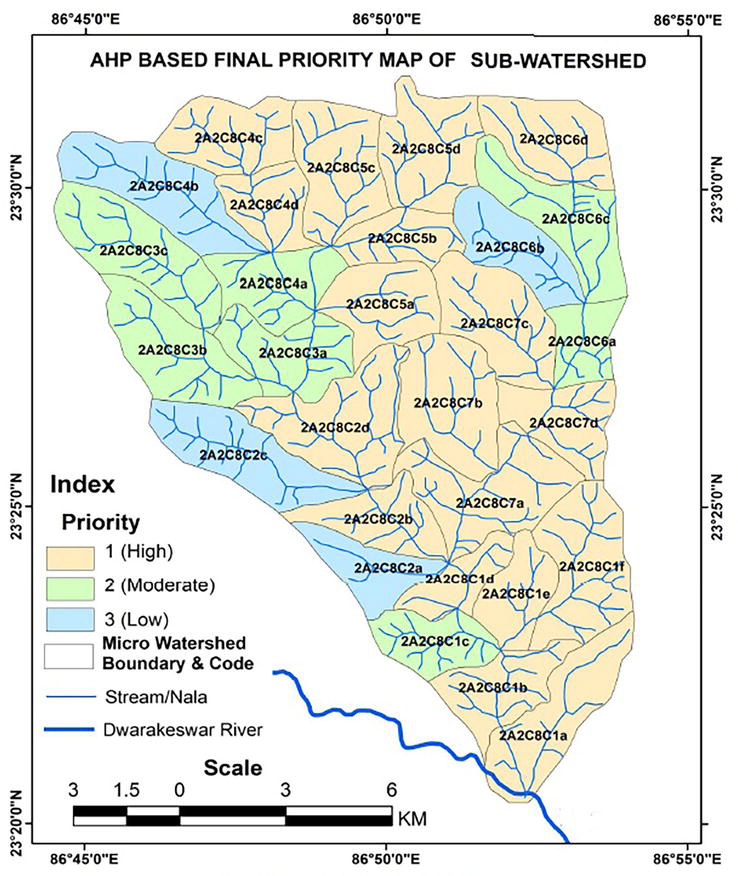
The methodology described above has been implemented for the Dangra sub-watersheds to determine the suitable of land for micro-watershed management and taking action plan [21]. The prioritization at micro watershed level for the sub-watersheds based on the following parameters; Water scarcity, Sediment Yield Index, Land Capability, Morphomatic parameters, Societal parameters, and Run-off (Tables 3 and 4).
As per the analysis in Table 5 of the total 29 micro-watershed in the sub-watershed eighteen micro-watersheds are fall under fast management stage twelve micro-watersheds, in second management stage seven micro-watershed and four under third management stage, whereas immediate action not required for development based on sub-watersheds (Figure 4).
Factors
Scarcity
SYI
Land capability
Morphometric
Societal
Run-off
Total
Action Plan
MWC
2A2C8C1a
46.07633
24.2953
12.76595183
8.592603084
10.05237
6.487265
108.2698
1
2A2C8C1b
46.07633
48.5906
12.76595183
8.592603084
10.05237
3.243632
129.3215
1
2A2C8C1c
138.229
48.5906
12.76595183
8.592603084
10.05237
3.243632
221.4741
2
2A2C8C1d
46.07633
48.5906
12.76595183
17.18520617
15.07855
3.243632
142.9403
1
2A2C8C1e
46.07633
48.5906
12.76595183
25.77780925
10.05237
6.487265
149.7503
1
2A2C8C1f
46.07633
24.2953
12.76595183
25.77780925
10.05237
3.243632
122.2114
1
2A2C8C2a
138.229
48.5906
12.76595183
17.18520617
10.05237
6.487265
233.3104
3
2A2C8C2b
92.15266
24.2953
12.76595183
17.18520617
10.05237
6.487265
162.9387
1
2A2C8C2c
138.229
48.5906
12.76595183
8.592603084
10.05237
9.730897
227.9614
3
2A2C8C2d
92.15266
24.2953
12.76595183
8.592603084
10.05237
3.243632
151.1025
1
2A2C8C3a
92.15266
24.2953
25.53190366
17.18520617
10.05237
3.243632
172.4611
2
2A2C8C3b
138.229
24.2953
12.76595183
25.77780925
10.05237
6.487265
217.6077
2
2A2C8C3c
92.15266
24.2953
25.53190366
25.77780925
10.05237
9.730897
187.5409
2
2A2C8C4a
92.15266
24.2953
25.53190366
17.18520617
5.026183
9.730897
173.9221
2
2A2C8C4b
92.15266
72.8859
25.53190366
17.18520617
10.05237
9.730897
227.5389
3
2A2C8C4c
46.07633
24.2953
38.29785549
17.18520617
5.026183
9.730897
140.6118
1
2A2C8C4d
46.07633
24.2953
25.53190366
17.18520617
10.05237
9.730897
132.872
1
2A2C8C5a
46.07633
24.2953
12.76595183
25.77780925
15.07855
6.487265
130.4812
1
2A2C8C5b
46.07633
48.5906
25.53190366
17.18520617
10.05237
9.730897
157.1673
1
2A2C8C5c
46.07633
24.2953
38.29785549
25.77780925
5.026183
9.730897
149.2044
1
2A2C8C5d
46.07633
24.2953
38.29785549
25.77780925
5.026183
9.730897
149.2044
1
2A2C8C6a
46.07633
72.8859
12.76595183
17.18520617
10.05237
9.730897
168.6967
2
2A2C8C6b
138.229
72.8859
25.53190366
17.18520617
10.05237
9.730897
273.6153
3
2A2C8C6c
138.229
24.2953
25.53190366
8.592603084
5.026183
9.730897
211.4059
2
2A2C8C6d
46.07633
48.5906
38.29785549
8.592603084
5.026183
9.730897
156.3145
1
2A2C8C7a
46.07633
24.2953
12.76595183
25.77780925
10.05237
3.243632
122.2114
1
2A2C8C7b
46.07633
24.2953
12.76595183
17.18520617
10.05237
3.243632
113.6188
1
2A2C8C7c
46.07633
48.5906
12.76595183
17.18520617
5.026183
6.487265
136.1315
1
2A2C8C7d
46.07633
48.5906
12.76595183
17.18520617
10.05237
6.487265
141.1577
1
Table 5.
AHP based Sub-Watershed Final Prioritization.
Figure 4.
AHP based final priority.
The multi-criteria evaluations of physical parameters of the sub-watersheds indicate that the area is facing a great water resources problem. Thematic information of scarcity zone, morphometric characters, surface runoff, sediment yield, land capability and socio-economy with demography were generated in the GIS environment using remote sensing data and field data. Therefore, all final prioritized value is assigned weightage to obtain normalized weightage by using analytical hierarchy process. Then all the parameters are integrated in the GIS environment to decide the soil conservation measures at the appropriate site in the watershed.
AHP provides an appropriate framework for the application of multi-criteria evaluation methods, whereas multi-criteria evaluation techniques add to GIS the means of performing trade-offs on contradicting objectives, giving weight-age to both multiple criteria as well as the knowledge of the decision maker. On the whole, this study demonstrated that the remote sensing, GIS and AHP techniques offer a useful integrated tool for the deciding micro watershed management plan with societal perspective towards development and planning.
2.Brunelli M. Introduction to the analytic hierarchy process. Springer briefs in. Operations Research. 2015;2015:83. DOI: 10.1007/978-3-319-12502-2
3.Rezakhani P. Fuzzy MCDM model for risk factor selection in construction projects. Engineering Journal. 2012;16(5):81-93. DOI: 10.4186/ej.2012.16.5.79
4.Dweiri F, Kumar S, Khan SA, Jain V. Designing an integrated AHP based decision support system for supplier selection in automotive industry. Expert Systems with Applications. 2016;62:273-283. DOI: 10.1016/j.eswa.2016.06.030
5.Riahi A, Moharrampour M. Evaluation of strategic management in business with AHP case study: PARS house appliance. Procedia Economics and Finance. 2016;26:10-21. DOI: 10.1016/S2212-5671(16)30011-9
6.Bosch D, Pease J, Wolfe ML, Zobel C, Osorio J, Cobb TD, et al. Community DECISIONS: Stakeholder focused watershed planning. Journal of Environmental Management. 2012;112:226-232. DOI: 10.1016/j.jenvman.2012.07.031
7.Gallego-Ayala J, Juízo D. Integrating stakeholders’ references into water resources management planning in the Incomati River Basin. Water Resource Management. 2014;28:527-540. DOI: 10.1007/s11269-013-0500-3
8.Montazar A, Zadbagher E. An analytical hierarchy model for assessing global water productivity of irrigation networks in Iran. Water Resource Management. 2010;24:2817-2832. DOI: 10.1007/s11269-010-9581-4
9.Srdjevic B, Medeiros YDP. Fuzzy AHP assessment of water management plans. Water Resources Management. 2008a;22:877-894. DOI: 10.1007/s11269-007-9197-5
10.Shabbir R, Ahmad SS. Water resource vulnerability assessment in Rawalpindi and Islamabad, Pakistan using Analytic Hierarchy Orocess (AHP). Journal of King Saud University—Science. 2016;28(4):293-299. DOI: 10.1016/j.jksus.2015.09.007
11.Anagnostopoulos KP, Petalas C, Pisinaras V. Water resources planning using the AHP and PROMETHEE multicriteria methods: The case of Nestos River-Greece. In: Presented at the 7th Balkan Conference on Operational Research, May 25-28, 2005. Constanta, Romania; 2005
12.Tangtham N. Status of socio-economic-institutional research and identification of needed researches for watershed management in Thailand. Kasetsart Journal of Social Sciences. 1986;7(2):217-226. Retrieved from: https://so04.tci-thaijo.org/index.php/kjss/article/view/243773
13.Thungngern TS, Wijitkosum S. Analytic hierarchy process for stakeholder participation in integrated water resources management. Engineering Journal. 2017;21(7):87-103
14.Mirchi A, Watkins D, Madani K. Modeling for watershed planning, management, and decision making. In: Vaughn JC, editor. Watersheds: Management. Restoration and Environmental Impact. Environmental Science. Engineering and Technology Series. 2010. e-book. ISBN: 978-1-61209-295-9. Available from: http://www.kysq.org/docs/Mirchi_Watershed.pdf
15.Ceballos-Silva A, Lopez-Blanco J. Delineation of suitable areas for crops using a multi-criteria evaluation approach and land use/ land cover mapping: A case study in Central Mexico. Agricultural Systems. 2003;77(2):117-136. DOI: 10.1016/S0308-521X(02)00103-8
16.World Bank Report. Thailand Environment Monitor: Integrated Water Resources Management—A Way Forward [Online]. 2017. Available from: http://documents.worldbank.org/curated/en/367151468303847751/Thailand-environment-monitor-integrated-water-resources-management-a-way-forward
18.Malczewski J. GIS based multi-criteria decision analysis: A survey of the literature. International Journal of Geographical Information Science. 2006;20:703-726. DOI: 10.1080/13658810600661508
19.Bera K, Banik P. Multi-criteria decision analysis (MCDA) for surface water management plan, a case study of Kansachara sub-watershed, West Bengal, India. Water Supply. 2019, 2019;19(7):2156-2162. DOI: 10.2166/ws.2019.096
20.Chakhar S, Mousseau V. GIS based multi-criteria spatial modeling generic framework. International Journal of Geographic Information Science. 2008;22:1159-1196. DOI: 10.1080/13658810801949827
21.Kumar B, Kumar U. Micro watershed characterization and prioritization using geomatics technology for natural resources management. International Journal of Geomatics and Geosciences. 2011;1(4):789-802
Written By
Kartic Bera, Jatisankar Bandyopadhyay and Pabitra Banik
Submitted: 03 February 2023Reviewed: 11 February 2023Published: 12 July 2023
 Open access peer-reviewed chapter