
Abstract
As the specter of climate change looms over urban agglomerations, this concept chapter delves into the transformative potential of GIS and Remote Sensing techniques in dissecting and mitigating its impacts. By intricately analyzing land-cover and surface temperature data, we unveil the nuanced effects of climate change on land surface temperature (LST) across varied land-cover types. Leveraging the expansive spatial coverage of remote sensing data, especially satellite images, we can meticulously monitor urban structures, offering invaluable insights into impervious surfaces and vegetated areas. This trove of information not only enlightens the current state and evolution of urban structures but also becomes the bedrock for effective urban planning strategies and climate change adaptation measures. In tandem, the amalgamation of remote sensing with GIS techniques facilitates a granular exploration of the intra-urban thermal environment and the intricate spatial links between urban vulnerability and characteristics. By delving into these insights, GIS and remote sensing emerge as indispensable allies in the quantification and monitoring of climate change impacts on urban agglomerations, guiding decisive measures for sustainable urban development and climate adaptation.
Keywords
- urban agglomerations
- climate change
- vulnerability
- resiliency
- disaster management
- GIS
- remote sensing
1. Introduction
Urban agglomerations are navigating an unprecedented era of challenges under the pervasive influence of climate change. The escalating temperatures, capricious alterations in precipitation patterns, and surges in extreme weather events pose formidable threats to the resilience and sustainability of urban areas worldwide [1]. In response, this chapter advocates the strategic deployment of Geographic Information Systems (GIS) and remote sensing techniques as powerful tools in comprehending and managing the multifaceted impacts of climate change on urban landscapes [2]. Our focus is on the confluence of land-cover and surface temperature data, unraveling the intricate relationships between different land-cover types and the ensuing shifts in land surface temperature (LST) [3]. The arsenal of remote sensing, particularly satellite imagery, comes to the forefront, affording us expansive spatial coverage and recurrently updated information essential for the vigilant monitoring of urban structures [4]. This chapter contends that this dynamic repository of data not only facilitates an understanding of the present urban milieu but becomes an indispensable asset in sculpting effective urban planning strategies and fortifying the adaptive measures against the onslaught of climate change.
The subsequent integration of GIS techniques with remote sensing adds another layer of sophistication to our analytical approach [5]. This union allows us to delve into the complex intra-urban thermal environment, deciphering the spatial variability of the connections between urban vulnerability and characteristics. As we navigate through these methodologies, the overarching aim is to provide a robust framework that quantifies, monitors, and analyzes the impacts of climate change on urban agglomerations [6]. This framework, fortified by GIS and remote sensing, is envisaged as a catalyst for informed decision-making processes, steering urban development toward sustainability and resilience. As we embark on this exploration, it becomes increasingly evident that GIS and remote sensing emerge not merely as technical tools but as indispensable allies in deciphering the intricate dance between climate change and urban agglomerations.
In this context, the integration of Geographic Information Systems (GIS) and remote sensing technologies has emerged as a powerful approach to assess and monitor the effects of climate change on urban landscapes. This amalgamation of advanced technologies forms the bedrock of our exploration, promising a comprehensive understanding of the intricate dynamics between climate change and urban agglomerations, which can be summarized in the following.
1.1 Utilizing land-cover and surface temperature data
GIS and remote sensing stand as pivotal tools in dissecting the impacts of climate change on land surface temperature (LST) under various land-cover types. Leveraging satellite imagery and cutting-edge remote sensing techniques, researchers gain access to robust datasets. This allows for a nuanced assessment of temperature variations across urban landscapes, a crucial insight for comprehending the contribution of different land-cover types to the urban heat island effect. The data becomes instrumental in formulating strategies to mitigate heat-related challenges in urban environments.
1.1.1 Monitoring urban structures
Remote sensing data, with its extensive spatial coverage and frequent updates, facilitates the meticulous monitoring of urban structures. This includes the dynamic tracking of changes in impervious surfaces like roads and buildings, alongside vegetated areas. The integration of GIS enhances this capability, enabling the creation of dynamic maps that vividly illustrate the evolution of urban structures over time. This real-time monitoring becomes a linchpin in supporting urban planning strategies, providing decision-makers with valuable insights into the current state and developmental trajectory of urban areas within municipal boundaries [7].
1.1.2 Supporting Urban Planning Strategies and Climate Change Adaptation
The synergy between GIS and remote sensing data offers indispensable information for supporting urban planning strategies and fortifying climate change adaptation measures. Decision-makers can leverage these tools to identify vulnerable areas, assess the impact of climate change on infrastructure, and devise targeted interventions to bolster urban resilience. The visualization of spatial data empowers planners to make informed decisions, steering the course toward sustainable urban development and the implementation of effective climate change adaptation measures [8].
1.1.3 Assessing intra-urban thermal environment
GIS techniques, in tandem with remote sensing, contribute significantly to the assessment of the intra-urban thermal environment. This involves unraveling the spatial variability of the links between urban vulnerability and characteristics. This nuanced understanding enables a more refined analysis of the impacts of climate change, guiding the development of localized adaptation strategies and the prioritization of resources based on the specific needs of different urban zones [9].
1.2 Research objectives
1.2.1 Spatial analysis of urban Heat Islands
Conduct an intricate spatial analysis utilizing GIS and remote sensing techniques to identify and characterize urban heat islands (UHIs) within different land-cover types. This involves assessing land surface temperature (LST) variations under various urban structures and natural features, providing insights into the intensity and distribution of heat islands.
1.2.2 Temporal monitoring of urban structures
Develop a comprehensive temporal monitoring system using remote sensing data to track changes in impervious surfaces and vegetated areas within urban agglomerations over time. This objective aims to unravel the dynamics of urban development and land-use changes, providing a basis for assessing the effectiveness of urban planning strategies in response to climate change.
1.2.3 Integration of climate change impacts into urban planning
Investigate the integration of GIS and remote sensing data into urban planning processes to enhance climate change adaptation strategies. This includes assessing the vulnerability of urban structures to climate change impacts, such as increased temperatures and extreme weather events. Develop recommendations for incorporating spatial information into urban planning frameworks to foster resilient and sustainable urban development.
1.2.4 Intra-urban thermal environment analysis
Explore the spatial variability of the links between urban vulnerability and characteristics within municipal boundaries. Utilize GIS techniques to assess the intra-urban thermal environment and identify hotspots of vulnerability. This research objective aims to provide a nuanced understanding of how different urban zones are affected by climate change, guiding the development of targeted adaptation measures for specific areas within the urban agglomeration.
1.3 Research scope
This research seeks to comprehensively assess approaches for the impacts of climate change on urban agglomerations by employing GIS and remote sensing techniques.
2. Methodology
This methodology presents a generic methodology that provides an integrated approach utilizing remote sensing and GIS techniques to comprehensively assess the impacts of climate change on urban agglomerations. The research initiates with the acquisition of satellite images for identifying land transformations and monitoring changes in the Earth’s surface, with a specific focus on urbanization and land use/land-cover changes. The leverage of remote sensing data, particularly satellite images, stems from their extensive spatial coverage and regular availability, enabling effective monitoring of urban structures and climate indicators. GIS is subsequently employed to analyze and visualize spatial data extracted from remote sensing, facilitating the assessment of climate-related indicators in urban areas. The synergy of remote sensing and GIS allows for the extraction of intricate information from urban surfaces, including land surface temperature (LST), imperviousness, and vegetation vitality indicators. To enhance efficiency, advanced technologies such as Artificial Intelligence (AI) are integrated to automate the measurement and evaluation of climate adaptation indicators in urban areas. Climate change vulnerability and adaptation assessments are conducted through a fusion of remote sensing data, GIS analysis, and numerical modeling systems, allowing for an in-depth analysis of the urban climate and thermal bioclimatic in urban agglomerations. The incorporation of Local Climate Zones (LCZ) based on remote sensing data and GIS techniques facilitates the analysis of climate change impacts on LST under different land-cover types in urban agglomerations. This comprehensive methodology aspires to provide a robust framework for understanding and addressing the intricate dynamics of climate change in urban environments.
The research methodology entails systematic data collection and preprocessing to ensure the reliability and accuracy of the analysis. Satellite imagery and remote sensing data specific to the study area will be acquired, capturing pertinent information on land-cover, surface temperature, and urban structures. To introduce a temporal dimension, time-series data will be collected to monitor changes over defined periods. The collected data will undergo rigorous preprocessing, incorporating radiometric and atmospheric corrections, geometric adjustments, and image normalization. GIS tools will be employed to integrate diverse datasets, facilitating the creation of precise spatial representations. Quality control measures will address sensor artifacts, enhancing the overall reliability of the dataset. This comprehensive approach to data collection and preprocessing is pivotal for generating robust insights into the impacts of climate change on urban agglomerations, ensuring the validity of subsequent analyses and supporting informed decision-making in urban planning and climate change adaptation strategies (Figure 1).
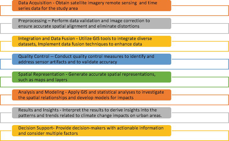
Figure 1.
Methodology flowchart.
3. Discussion
This study attempts to unravel the complexities of climate change impacts on Urban Agglomerations. It employed a comprehensive methodology, integrating GIS and remote sensing techniques, to assess the multifaceted impacts of climate change on urban agglomerations [10]. The spatial analysis of urban heat islands (UHIs) unveiled intricate relationships between land surface temperature (LST) variations and different land-cover types, emphasizing the significance of understanding nuances within urban structures [11]. The temporal monitoring of urban structures uncovered dynamic patterns of change in impervious surfaces and vegetated areas, underscoring the evolving nature of urban development in response to climate influences. Integrating climate change impacts into urban planning processes proved to be a pivotal aspect, emphasizing the need for vulnerability assessments and the incorporation of spatial information for effective adaptation strategies [12]. The intra-urban thermal environment analysis further nuanced our understanding, highlighting specific vulnerable hotspots within municipal boundaries [13]. The success of the methodology relied heavily on robust data collection and preprocessing, ensuring the reliability of the analyses conducted (Figure 2) [14].
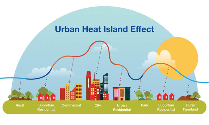
Figure 2.
Urban Head Islands effect, as it relates to urban agglomerations (after the City of Little Rock, Arkansas).
3.1 Preprocessing steps and data quality
The preprocessing steps, including radiometric and atmospheric corrections, geometric adjustments, and data fusion, played a critical role in enhancing the accuracy of the dataset. Quality control measures addressed potential artifacts, contributing to the overall credibility of the findings. By systematically addressing sensor-specific variations and atmospheric effects, radiometric corrections ensured that the data accurately reflected the true surface characteristics. Geometric corrections eliminated distortions, guaranteeing accurate spatial alignment crucial for meaningful spatial analyses. Data fusion techniques enriched the integrated dataset, providing a comprehensive view of urban structures and climate indicators. The meticulous approach to quality control reinforced the reliability of the dataset, enhancing the robustness of subsequent analyses.
3.2 Spatial representation and analysis
The spatial representation of integrated datasets facilitated a visually compelling depiction of the complex interactions within urban areas. Accurate spatial representations, including maps and layers, served as effective tools for conveying the nuanced relationships between urban structures, land-cover, and surface temperature. These visualizations were instrumental in communicating complex findings to diverse stakeholders, aiding in the interpretation of spatial patterns and trends. The analysis and modeling phase provided quantitative insights into spatial relationships, enabling the development of models that can inform future projections of climate change impacts on urban landscapes.
3.3 Decision support and implications
The results presented in this study contribute valuable information for decision-makers involved in urban planning and climate change adaptation. By unraveling the complexities of climate change impacts on urban agglomerations, this research provides a foundation for evidence-based decision-making. The findings emphasize the importance of spatially informed strategies for sustainable urban development, underscoring the need for targeted interventions in vulnerable areas. As we navigate an era of rapid urbanization and climate change, the integration of GIS and remote sensing techniques proves indispensable for shaping resilient and adaptive cities.
The study offers crucial managerial implications for decision-makers involved in urban planning and climate change adaptation. By unraveling the complexities of climate change impacts on urban areas, the research provides a foundation for evidence-based decision-making. Decision-makers can utilize the insights gained from GIS and remote sensing techniques to inform urban planning strategies effectively. The identification of vulnerable areas, conducted through spatial analysis, allows for targeted interventions, optimizing resource allocation for climate change adaptation. The study’s emphasis on spatially informed strategies underscores the need for decision-makers to integrate GIS and remote sensing data into planning frameworks. This integration ensures that climate change considerations are seamlessly embedded in urban development plans, promoting sustainable and resilient cities. The spatial analysis further aids in the identification of vulnerable hotspots within urban agglomerations, guiding decision-makers in prioritizing areas requiring immediate attention. Resource allocation becomes more effective as decision-makers gain an understanding of the spatial variability of climate change impacts, allowing for nuanced, tailored approaches to diverse urban zones. The study advocates for a proactive stance by decision-makers, leveraging real-time monitoring capabilities provided by GIS and remote sensing for swift responses to emerging challenges. Additionally, the findings stress the importance of community engagement and awareness, enabling decision-makers to foster collaboration and inclusivity in climate resilience initiatives. In essence, the research offers a comprehensive framework for decision-makers to navigate the complexities of urbanization and climate change, emphasizing the indispensable role of GIS and remote sensing in shaping resilient and adaptive cities for the future.
4. Conclusion
In conclusion, this study showcases the significance of employing GIS and remote sensing techniques to comprehensively understand and address the impacts of climate change on urban agglomerations. Moving forward, continuous advancements in technology, including the integration of Artificial Intelligence, offer opportunities to further enhance the precision and efficiency of climate change impact assessments. Future research endeavors should explore the incorporation of additional socio-economic and demographic factors to deepen our understanding of vulnerability within urban populations. Additionally, longitudinal studies could provide insights into the long-term effectiveness of implemented urban planning strategies. Overall, as urban areas continue to evolve in response to climate challenges, the integration of spatial technologies remains pivotal for informed decision-making and sustainable urban development.
5. Future directions
5.1 Adaptation strategy for climate-resilient urban development
In response to the identified vulnerabilities revealed through our GIS and remote sensing analysis, an adaptive strategy is proposed to enhance the resilience of urban agglomerations. This strategy encompasses targeted interventions addressing specific vulnerabilities, while also integrating broader measures related to urban heat island (UHI) mitigation, flood resilience, and sustainable urban planning.
5.1.1 Tailored vulnerability interventions
Green Infrastructure Implementation: Identify and prioritize vulnerable hotspots within the urban fabric, particularly areas experiencing elevated land surface temperatures. Implement green infrastructure initiatives, including the creation of urban green spaces and increased tree canopy coverage, to mitigate heat island effects and enhance overall urban resilience.Localized Flood Management: Develop localized flood management strategies tailored to areas prone to flooding. This may include the implementation of permeable surfaces, green roofs, and strategically designed drainage systems to reduce surface runoff and enhance flood resilience.
5.1.2 Urban heat island mitigation
Cool Roof Initiatives: Encourage and incentivize the adoption of cool roofing technologies, especially in areas with high impervious surface concentrations. Cool roofs reflect more sunlight and absorb less heat, contributing to a reduction in surface temperatures and mitigating UHI effects.Tree Canopy Expansion: Prioritize the expansion of urban tree canopy coverage, focusing on areas identified as UHI hotspots. Trees provide shade, enhance evapotranspiration, and contribute to a cooler microclimate, effectively countering the urban heat island effect.
5.1.3 Flood resilience measures
Elevated Infrastructure Design : In flood-prone areas, promote the construction of elevated or flood-resistant infrastructure. Elevating critical facilities and residential structures above flood levels reduces the impact of inundation and safeguards against potential damages.Community Early Warning Systems: Implement community-based early warning systems to enhance preparedness for flood events. Disseminate timely information and evacuation protocols, ensuring that vulnerable populations are well-informed and can respond effectively to flood threats.
5.1.4 Sustainable urban planning
Compact and Mixed-Use Development: Encourage compact and mixed-use urban development patterns to minimize the expansion of impervious surfaces. This approach promotes walkability, reduces the urban heat island effect, and enhances the overall sustainability of urban areas.Integrated Land-Use Planning: Integrate climate resilience considerations into land-use planning processes. Ensure that future urban development adheres to sustainable practices, minimizing environmental impact and promoting long-term resilience to climate change.
By implementing this adaptive strategy, we aim to create climate-resilient urban agglomerations that not only address specific vulnerabilities but also foster sustainable development practices. This multifaceted approach acknowledges the interconnected nature of climate change impacts, positioning urban areas for a more resilient and sustainable future. The success of this strategy hinges on collaborative efforts among policymakers, urban planners, and communities to enact and sustain these adaptive measures.
5.1.5 Forging resilient urban futures in the face of climate change
This research, employing a holistic approach integrating GIS and remote sensing techniques, has illuminated the intricate dynamics of climate change impacts on urban agglomerations. The spatial analysis uncovered the complex relationships between land surface temperature variations and diverse land-cover types, emphasizing the need for a nuanced understanding of urban structures. Temporal monitoring revealed the dynamic nature of urban development, urging the adoption of adaptive strategies to navigate evolving climate challenges. The integration of climate change impacts into urban planning processes underscored the necessity of vulnerability assessments and spatially informed strategies for resilient urban futures.
In addressing specific vulnerabilities, the proposed adaptive strategy encapsulates tailored interventions while aligning with broader goals of urban heat island mitigation, flood resilience, and sustainable urban planning. Initiatives such as green infrastructure implementation, cool roof adoption, and elevated infrastructure design aim to fortify urban areas against the impacts of a changing climate. These strategies not only mitigate specific vulnerabilities but also contribute to the overarching goal of fostering sustainable and climate-resilient urban development.
Crucially, the success of these adaptation measures hinges on robust data collection and preprocessing, ensuring the reliability of our analyses. Quality-controlled, integrated datasets form the foundation upon which informed decision-making can occur. The spatial representation of these datasets serves as a visual roadmap for identifying vulnerabilities and formulating targeted interventions.
As urbanization and climate change continue to shape our world, the findings of this research contribute substantively to the discourse on resilient urban futures. The proposed adaptive strategy provides a blueprint for cities globally, offering a flexible framework that can be tailored to diverse urban contexts. By acknowledging the interconnected nature of climate change impacts and embracing adaptive strategies, urban areas can forge resilient paths forward, fostering sustainable development in the face of an ever-changing climate. As we navigate the challenges of the twenty-first century, the fusion of advanced technologies, data-driven insights, and strategic planning emerges as a beacon guiding cities toward climate resilience and a sustainable urban future.
5.2 Future work: charting paths for continued research and action
While this research has provided valuable insights into the impacts of climate change on urban agglomerations and proposed an adaptive strategy, there remain avenues for future exploration and enhancement:
5.2.1 Fine-scale analysis
Future research could delve deeper into fine-scale analyses, examining micro-level variations in land surface temperature and vulnerabilities within urban areas. This could involve higher-resolution remote sensing data and more advanced GIS techniques to capture localized nuances.
5.2.2 Dynamic modeling
Developing dynamic models that incorporate predictive capabilities would enhance our ability to foresee the evolving impacts of climate change on urban landscapes. Incorporating climate change projections and urban development scenarios would offer a forward-looking perspective for more effective long-term planning.
5.2.3 Community engagement and social dynamics
Expanding the research scope to include community engagement and social dynamics would provide a more comprehensive understanding of resilience. Investigating how communities perceive and respond to climate change impacts can inform adaptive strategies that align with local needs and priorities.
5.2.4 Multi-criteria decision analysis
Integrate multi-criteria decision analysis (MCDA) approaches to prioritize and optimize adaptation measures. This could involve considering not only climate-related factors but also economic, social, and governance dimensions to ensure comprehensive and inclusive decision-making.
5.2.5 Technological advances
Embrace emerging technologies, such as advanced satellite sensors and machine learning algorithms, to enhance the accuracy and efficiency of data collection, analysis, and modeling. This could provide more detailed and real-time information for decision-makers.
5.2.6 Long-term monitoring
Establishing long-term monitoring programs to track the effectiveness of implemented adaptation measures is crucial. This would provide continuous feedback on the success of strategies, allowing for adaptive management in response to changing conditions.
5.2.7 Cross-disciplinary collaboration
Foster collaboration between climate scientists, urban planners, social scientists, and policymakers to create an integrated and holistic approach. Cross-disciplinary efforts can provide a more comprehensive understanding of the challenges and facilitate the development of effective solutions.
5.2.8 Global comparative studies
Undertake global comparative studies to assess the transferability and scalability of adaptation strategies across diverse urban contexts. Understanding how different cities respond to similar challenges can provide valuable insights for shared learning and best practices.
References
- 1.
Boulanger SOM. Urban adaptation to climate change state of the art: Evaluating the role of adaptation assessment frameworks through a systematic and bibliometric analysis. Sustainability. 2023; 15 (13):10134. DOI: 10.3390/su151310134 - 2.
Barat A, Kumar S, Aakriti Asim P, Sarthi P. Monitoring of urban climate using geospatial techniques. In: Advances in Urbanism, Smart Cities, and Sustainability. Boca Raton, Florida, USA: CRC Press; 2022. DOI: 10.1201/9781003126195-30 - 3.
Lu-Yun L, Yu S, Komi H, Bedra B, Zhang M. Investigating the spatial heterogeneity of urban heat island responses to climate change based on local climate zones. Sustainability. 2023; 15 (7):6298. DOI: 10.3390/su15076298 - 4.
Ricardo V. Remote sensing and AI for building climate adaptation applications. Results in Engineering. 2022; 15 :100524-100524. DOI: 10.1016/j.rineng.2022.100524 - 5.
David H, Julián G, Díaz A, Martín A, Emilio M, Cobos G. Spatiotemporal analysis of urban thermal effects caused by heat waves through remote sensing. Sustainability. 2022; 14 (19):12262. DOI: 10.3390/su141912262 - 6.
Linda O, Mearns Stephan R, Sain Lai-Yung R, Melissa L, Seth B, Sébastien MG, et al. Climate change projections of the North American regional climate change assessment program (NARCCAP). Climatic Change. 2013; 120 (4):965-975. DOI: 10.1007/S10584-013-0831-3 - 7.
Stenka V, Alby D, Meier RF, Nouri H, Schulz C, Soulsby C, et al. City-wide, high-resolution mapping of evapotranspiration to guide climate-resilient planning. Remote Sensing of Environment. 2023; 287 :113487. DOI: 10.1016/j.rse.2023.113487 - 8.
Ritu G. Evaluating the impact of climate change on the urban environment using geospatial technologies in Bhubaneswar, India. The International Archives of the Photogrammetry, Remote Sensing and Spatial Information Sciences. 2022; XLVIII-4/W5-2022 :159-166. DOI: 10.5194/isprs-archives-xlviii-4-w5-2022-159-2022 - 9.
Abida F, Ul M, Harmeet S, Ahmed SP. Assessment of spatiotemporal changes in land use/land cover of North Kashmir Himalayas from 1992 to 2018. Modeling Earth Systems and Environment. 2020; 6 (2):1189-1200. DOI: 10.1007/S40808-020-00750-9 - 10.
Dong G, Xie Y, Wang Y, Fan D, Tian Z. Ensemble projection of extreme precipitation over China based on three dynamical downscaling simulations. Frontiers in Earth Science. 2021; 9 :823. DOI: 10.3389/FEART.2021.755041 - 11.
Ghasem F, Shahriar KM, Manijeh GT, Patel ND. Effects of climate change on dynamics of agricultural lands and cultivation pattern, a case study of Urmia County, Iran. Arabian Journal of Geosciences. 2022; 15 (21):1643. DOI: 10.1007/s12517-022-10926-5 - 12.
Thomas E, Thomas E, Vitus H, Gunther S, Michael T, Thilo W, et al. Large-area assessment of impervious surface based on integrated analysis of single-date Landsat-7 images and geospatial vector data. Remote Sensing of Environment. 2009; 113 (8):1678-1690. DOI: 10.1016/J.RSE.2009.03.012 - 13.
Daisy S, Martin S, Aguayo LG, Wallace L, Reinke K, McLennan B. Perceptions of land use and land cover analysed using geospatial data. Applied Geography. 2022; 146 :102757-102757. DOI: 10.1016/j.apgeog.2022.102757 - 14.
Lin TH, Liu GR, Chen YC. Remote sensing of smoke plumes with moderate resolution imaging spectroradiometer reflectance measurements. Journal of Applied Remote Sensing. 2010; 4 (1):041876-041876. DOI: 10.1117/1.3505481