
Abstract
This study investigates the significant issue of rain-induced signal attenuation in satellite communication, specifically focusing on television receive-only (TVRO) stations operating in the Ku band across diverse Nigerian locations. Utilizing a comprehensive dataset of point rain rate distribution and the ITU rain attenuation model, the study comprehensively assesses how rainfall impacts signal quality. The findings highlight that southern regions consistently display high decibel (dB) values, indicating increased susceptibility to signal disruptions during heavy rainfall, while a comparative analysis between two key satellites, EUTELSAT 36B and INTELSAT 20, consistently favors the former in terms of signal resilience during adverse weather conditions. In contrast, northern regions generally exhibit lower dB values, suggesting a higher degree of signal resilience during rainfall events. These insights underscore the importance of considering location-specific and satellite-specific factors when designing satellite communication systems, emphasizing the need for robust infrastructure and strategic satellite selection to mitigate the effects of rain-induced attenuation. This study provides valuable guidance to engineers and service providers, enabling them to make informed decisions to minimize signal disruptions and enhance overall network reliability, particularly in regions susceptible to rain-induced attenuation.
Keywords
- rain-induced attenuation
- satellite communication
- signal degradation
- communication reliability
- rainfall rates
1. Introduction
Rainfall can have a severe impact on the performance of microwave systems operating at frequencies above 10 GHz [1]. This phenomenon, known as rain attenuation or rain fade, results in the fading of propagating signals and can significantly degrade the quality and reliability of telecommunication systems during rainy periods. According to the studies conducted, rain attenuation has been identified as a major obstacle in the design of microwave communication links operating at higher frequencies [2, 3]. The attenuation caused by rainfall depends on various factors, such as the intensity of the rain, the size and shape of raindrops, and the distance between the transmitting and receiving antennas [4, 5]. The effect of heavy or intense rainfall is more pronounced in tropical and subtropical regions where the frequency and intensity of rain occurrences are higher [5, 6, 7].
In such regions, the presence of large raindrops and a higher rainfall intensity further exacerbate the problem and increase the severity of signal degradation. These large raindrops can cause significant scattering and absorption of microwave signals, leading to a decrease in signal strength and an increase in error rates. It has been observed that the size distribution of raindrops can vary depending on the geographical location, which in turn strongly influences the specific attenuation caused by rainfall and, consequently, the overall rain attenuation [8, 9]. Rainfall intensity, on the other hand, can also vary significantly depending on the location and meteorological conditions, further impacting the extent of signal degradation caused by rainfall [7, 10]. Furthermore, rainfall can also affect the polarization of the electromagnetic wave as it propagates through raindrops [5]. This change in polarization can further contribute to signal degradation and a reduction in the quality of the received signal. Moreover, the magnitude of rain attenuation is also influenced by other parameters, such as rain temperature, drop velocity, drop orientation, and transmitting frequency [7].
This is particularly relevant in areas with high rainfall rates, such as Nigeria, where excessive rainfall is a common occurrence throughout the year. Moreover, rainfall rates can vary significantly in small locations over short distances, making rain attenuation even more significant in causing propagation loss and affecting millimetric and microwave signals. Rain attenuation is primarily caused by two factors: scattering and absorption of the electromagnetic signal by water droplets in the atmosphere [11]. These factors lead to a reduction in signal strength and quality, resulting in outages, unavailability, and poor service performance. Several sources confirm that rainfall attenuation becomes significant and disruptive in satellite communications at frequencies above 10 GHz. The severity of rain attenuation is further exacerbated in tropical regions due to the heavy rainfall intensity and the presence of large raindrops, as shown in Figure 1. It is important to note that the size distribution of raindrops can vary depending on geographical location, which in turn strongly influences the rain-specific attenuation and overall rain attenuation. Rainfall attenuation has a direct impact on the performance of microwave communication systems, limiting the scope of coverage and degrading system performance. Understanding the impact of rainfall on microwave signals is crucial for designing and maintaining reliable communication systems.
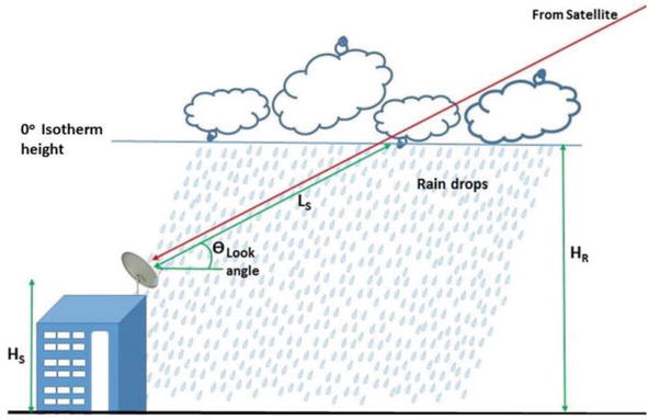
Figure 1.
Geometry of a typical rain-degraded satellite-earth link [
Figure 1 demonstrates that raindrops, in the context of typical Ku-band reception via the earth-space link, can result in the absorption, scattering, diffraction, and depolarization of electromagnetic signals. Satellite broadcast in the Ku-band (12–18 GHz) offers smaller antennas and less interference at higher frequencies than traditional terrestrial broadcast in the Very High Frequency (VHF) (30–300 MHz) and Ultra High Frequency (UHF) (300–3 GHz) bands. However, this frequency advantage is counterbalanced by a reduction in wavelength.
The average raindrop size (ARS) is defined by a diameter of 1.67 mm [4], but signals in the 12–18 GHz range exhibit wavelengths ranging from 25 to 16.7 mm. This implies that the wavelength of the signal is consistently greater than the typical size of rain droplets, which typically range in diameter from 0.1 to 5 mm. Nevertheless, despite the discrepancy in size, the signal encounters increased attenuation when rain is present. For frequencies up to 3 GHz, the droplet size in the Rayleigh scattering by raindrops is considerably lower than the wavelength. This function relates to the scattering characteristics of raindrops, which are affected by factors such as the size, shape, complex permittivity, and frequency of the signal [4].
Rainfall statistics and studies on rain-induced attenuation in Nigeria play a crucial role in the design and planning of reliable communication systems and infrastructure development in the country. Accurate knowledge of the rainfall rate and its impact on communication systems is essential for ensuring reliable transmission and minimizing signal loss due to rain-induced attenuation. Research efforts have been made in the past few decades to characterize the statistical and dynamic aspects of rainfall rate and rain attenuation in different regions of Nigeria. These studies have shed light on the variability and intensity of rainfall in different parts of the country and have provided valuable insights into the attenuation of radio waves during rainfall events.
For instance, studies conducted by [13] Ajayi in Ile-Ife and [14, 15] Ilorin have provided some insights into the rainfall characteristics and rain-induced attenuation in these locations. However, the availability of comprehensive rainfall data analysis remains limited in certain regions of Nigeria. Specifically, there is a lack of robust rainfall data analysis and studies on rain-induced attenuation covering several parts of Nigeria. This knowledge gap poses challenges for the planning and design of communication systems in this region, as rain-induced attenuation can significantly affect the reliability and performance of these systems. Obtaining accurate and reliable information on rain rate statistics and its impact on radio wave attenuation is vital for the effective design and planning of communication systems in this region. This study aims to evaluate the influence of rainfall-induced signal attenuation on satellite communication in various Nigerian regions, especially for digital satellite television as a typical application operating at frequencies above 10 GHz. By utilizing comprehensive rain rate data and the ITU rain attenuation model, the research seeks to assess the susceptibility of different locations and satellite systems to signal disruptions, facilitating the development of strategies to improve communication reliability during adverse weather conditions.
2. Related studies
Several studies have been conducted to investigate rain attenuation in Nigeria, which is a crucial factor affecting the quality of wireless communication systems. These studies aim to understand the characteristics of rain attenuation, such as its frequency dependence, temporal and spatial variations, and its impact on different frequency bands used for wireless communication.
The research conducted in Nigeria has identified the important factors affecting rain attenuation, including frequency, rain rate, drop size distribution, drop shape, and atmospheric conditions, leading to a better understanding and characterization of rain attenuation in the region. For example, the study in Semire et al. [16] explores rainfall trends and variability in southwestern Nigeria, revealing a steady increase and slightly unstable volume variation, with higher attenuation in years due to increasing trend and frequency variability. The study by Omotosho and Oluwafemi [17] examines rainfall’s impact on radio waves for fixed satellite service in Nigeria, finding practicable availability in the Ku, Ka, and V bands over different regions of the country. The study in [18] examines the impact of rainfall on digital satellite television reception in Akure, Nigeria, revealing signal squelching and complete loss at rainfall intensities above 64 mm/h.
The paper Ojo et al. [19] presents rain-rate contour maps for Nigerian link and network power sizing, developed using Moupfouma-Martin and Rice-Holmberg statistical methods for tropical regions. Obiyemi et al. [20] presents an experimental assessment of rain attenuation in Nigeria, analyzing cumulative rain rate distributions and fade margin estimation for various stations, revealing spatial variability. In a similar study on rain heights in satellite communication systems in Nigeria, the study by [21, 22, 23] reveals an increasing trend in Nigeria’s rain heights, with ITU-R recommended values underestimating them, and suggests a preference for GPM data for estimating rain heights. This study by [24, 25] analyzes tropical rain data from the TRMM satellite to predict attenuation due to precipitation phenomena, revealing seasonal, rainfall type dependence, and overestimation of rain heights in Nigeria.
The study by Ojo et al. [26] examines the influence of weather factors, notably rain-induced attenuation and various hydrometeors, on 5G satellite communication channels. The implementation of a dynamic adaptive intelligent scheme (DAIS) using fuzzy logic demonstrates noteworthy enhancements in service quality, achieving a reduction in power and signal-to-noise ratio (SNR) demands without compromising data integrity. These findings hold notable relevance for satellite and wireless network performance, especially within the context of Nigeria’s adoption of digital video broadcasting (DVB).
The study by Ojo et al. [27] presents contour maps as useful tools for rain rate and rain attenuation prediction, utilizing 30 years of rainfall data in Nigeria. These maps have been useful in designing microwave links, offering valuable insights for engineers. Based on data from ground-based precipitation measurements in Nigeria, Ojo [28] highlights the relationship between co-polar attenuation, cross-polar discrimination (XPD), and rainfall rates across different elevation angles and frequencies. Using a 10-year weather dataset for locations in Northern Nigeria, Orji et al. [29] examines the impact of rain on signal strength over the Ku and V bands, with results showing significant effects in V-band frequencies. On experimental efforts on the quantification of the attenuation induced on the typical Ku satellite-earth link, efforts documented in the studies in Refs. [18, 30, 31, 32] provide pronounced evidence on the degrading impacts of rain on digital satellite television applications over the region. Studies in Ref.s [33, 34] explore rain rate and attenuation across Nigeria’s climatic zones, emphasizing the worst months’ impact on earth-space radio links and presenting useful statistics such as the Average Worst Month and Average Yearly Worst Month for communication link designs over specified locations across Nigeria.
The current state of research on rainfall and its associated signal attenuation in Nigeria is marked by a notable gap in knowledge [33], which has significantly been influenced by the dearth of data. Addressing this gap is, however, imperative in order to enhance the reliability of communication networks across the country’s diverse climatic regions.
3. Methodology
3.1 Nigerian climatology
Nigeria boasts an extensive range of geographical features and climates due to its strategic location between 4 and 14 degrees north latitude and 2 and 15 degrees east longitude in Western Africa. This positioning exposes the country to a rich tapestry of environmental diversity. The climate of Nigeria is intricately shaped by the dynamic seasonal movements of the intertropical discontinuity (ITD). During the wet or rainy season, which typically spans from April to October, Nigeria experiences the dominance of moist south-westerly winds originating from the South Atlantic Ocean. These winds carry a vital payload of moisture, crucial for sustaining the nation’s rainfall patterns and frequent thunderstorms [25].
Conversely, the dry season, often referred to as Harmattan, extends from November to March. This period witnesses the north-easterly migration of dust particles from the vast Sahara Desert, sweeping across the entire country. These annual climatic shifts are driven by a combination of factors, including fluctuating temperatures, variations in precipitation levels, and other meteorological phenomena. Thanks to its equatorial location, Nigeria is blessed with a consistently high percentage of daylight year-round, contributing to its unique and diverse climate. This diverse climatic mosaic not only influences the environment but also plays a significant role in shaping the country’s culture, agriculture, and way of life.
3.2 Rain attenuation estimates on digital satellite TV links
A comprehensive dataset detailing the distribution of point rain rate (R0.01 in mm/h) across specific locations across Nigeria, as documented in studies [17, 35] in the references, was employed for this study. The dataset includes point rainfall rates from 37 stations in Nigeria between 1998 and 2006, as derived from the Tropical Rainfall Measuring Mission (TRMM) satellite sensors, specifically the Microwave Imager (TMI, 3A12 V6) and other satellite sources (3B43 V6) as outlined in Ref. [17]. The calculations involved deriving total rain accumulation (M) and point rainfall rates, with estimates aligning well with comparable data from the ITU-R database and in-situ ground-based data for the same locations. Rainfall rates were computed based on regional climatic parameters, including the thunderstorm ratio, using the method derived by the study [36] in the references, and the average total rain deduced per year is presented in Figure 2 for the observation period.
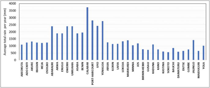
Figure 2.
Average total rain per year (mm) estimated from rain events in Nigeria as derived from TRMM 3B43V6 data: January 1998–December 2006 [
The study focuses on the earth station endpoints of the communication links, specifically television receive-only (TVRO) stations, as depicted in Figure 3 for 37 satellite-earth links in the Ku band. This figure illustrates the precise locations of these selected sites in relation to the existing rain rate distribution across Nigeria. It’s important to note that our selection process for these sites was deliberate, with the goal of ensuring a balanced representation of Nigeria’s diverse physical and climatic characteristics. Each chosen site was carefully considered to capture the unique geographical and environmental features of different regions within the country.
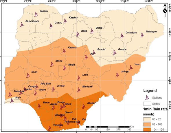
Figure 3.
TV reception stations (TVRO) spread across Nigeria with point rain rate distribution.
The two Ku transponders considered have a robust footprint over the region and prominently deliver satellite TV content across the region. They are EUTELSAT 36B with an orbital position of 36°E, an effective isotropic radiated power (EIRP) of 48 dBW, and a transmit frequency of 12.245 GHz, while the second one is INTELSAT 20 with an orbital position of 68.5°E, an EIRP of 48.5 dBW, and a transmit frequency of 12.722 GHz. One crucial factor in predicting rain attenuation is the elevation angle, and this parameter is influenced by two key factors: the orbital position of the satellites considered in the communication system and the geographic coordinates (latitude and longitude) of the earth station. Consequently, the look angle, which plays a vital role in signal propagation, exhibits significant variations across our designated communication links and from site to site, adding complexity to our analysis.
To construct a comprehensive rain attenuation map for Nigeria, the ITU rain attenuation model, detailed in the recommendation [37], was employed for quantifying the rain-induced attenuation over the links for each Ku transponder. This model relies on specific input parameters, including point rainfall rate (0.01% of an average year in mm/h) at the location, Earth station altitude above sea level (in km), elevation angle, latitude of the Earth station (in degrees), operating frequency (in GHz), and the standardized effective Earth radius of 8500 km. These parameters collectively enable a precise assessment of rain-induced signal attenuation across Nigeria’s diverse geographical and climatic regions, enhancing the robustness of the study.
4. Results and discussions
The rain attenuation contour maps offer valuable insights into the susceptibility of various Nigerian locations to rain-induced signal degradation, with a specific focus on two satellites, EUTELSAT 36B and INTELSAT 20, represented in decibels (dB). Based on the estimates in Figures 4 and 5 for rain-induced attenuation of 0.001% of the time, southern regions, including Yenagoa, Umuahia, and Owerri, consistently exhibit high dB values, ranging from approximately 49 to 52 dB for INTELSAT 20, indicating their heightened vulnerability to signal disruptions during heavy rainfall events. These areas experience substantial signal attenuation, underlining the need for robust communication infrastructure to ensure reliable services.
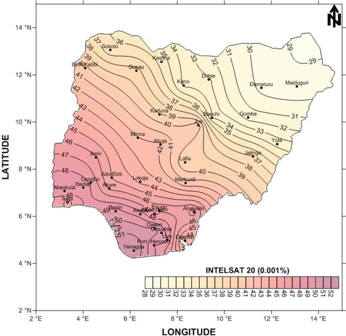
Figure 4.
A contour map depicting 0.001% rain attenuation (in dB) for typical Ku-band links on INTELSAT 20.
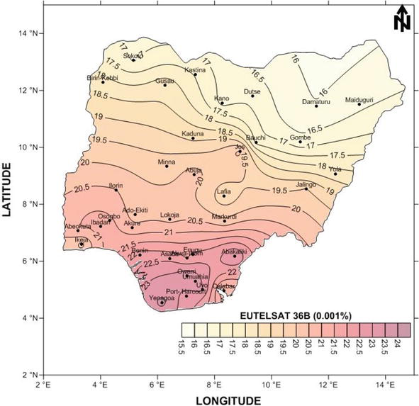
Figure 5.
A contour map depicting 0.001% rain attenuation (in dB) for typical Ku-band links on EUTELSAT 36B.
Furthermore, the comparison between the two satellites reveals a consistent pattern, with INTELSAT 20 consistently reporting higher dB values compared to EUTELSAT 36B across the considered locations. This suggests that INTELSAT 20 is more susceptible to signal disruptions caused by rain, emphasizing the importance of satellite selection in mitigating the effects of adverse weather conditions. Conversely, northern regions like Kano, Sokoto, and Maiduguri generally exhibit lower dB values, indicating a higher degree of signal resilience during rainfall events.
The estimates in Figures 6 and 7, expressed in decibels (dB), provide valuable insights into the impact of rainfall on signal quality for various Nigerian locations and two satellites, EUTELSAT 36B and INTELSAT 20, focusing on the 0.01% percentage of the time. Southern regions, including Uyo, Yenagoa, Owerri, and Umuahia, consistently report higher dB values, ranging from approximately 30 to 31.52 dB for INTELSAT 20. These figures underscore the susceptibility of these areas to significant signal attenuation during rainfall events, highlighting the critical need for robust communication infrastructure to ensure reliable services in these regions.
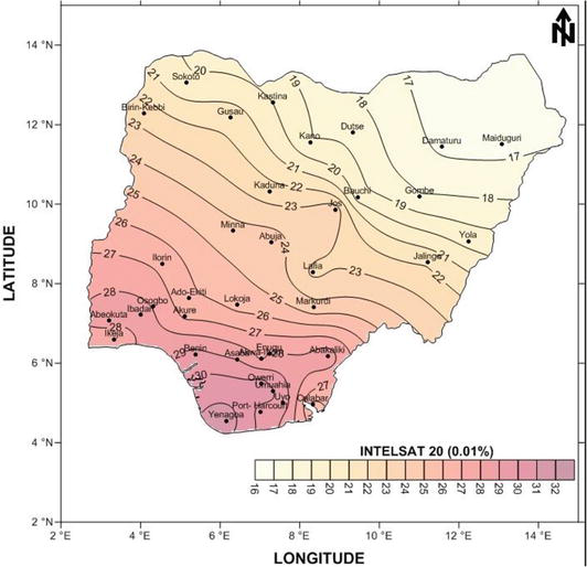
Figure 6.
A contour map depicting 0.01% rain attenuation (in dB) for typical Ku-band links on INTELSAT 20.
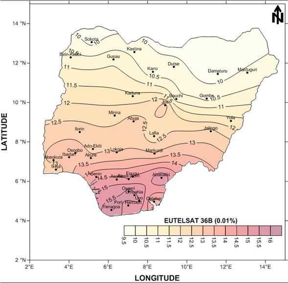
Figure 7.
A contour map depicting 0.01% rain attenuation (in dB) for typical Ku-band links on Eutelsat 36B.
Furthermore, the satellite comparison reveals that INTELSAT 20 consistently records higher dB values than EUTELSAT 36B across the considered locations. For instance, in Yenagoa, INTELSAT 20 demonstrates a dB value of 31.52, while EUTELSAT 36B records 15.84 dB. This consistent pattern indicates that INTELSAT 20 is more susceptible to signal disruptions caused by rain compared to EUTELSAT 36B. Conversely, northern regions such as Kano, Sokoto, and Maiduguri generally exhibit lower dB values, ranging from approximately 16.69 to 20.15 dB for INTELSAT 20, highlighting their greater signal resilience during rainfall events.
The rain-induced attenuation figures in Figures 8 and 9, expressed in decibels (dB) for the 0.1% time interval, provide further evidence of the significant influence of rainfall on signal quality in various Nigerian locations. Southern regions such as Uyo, Yenagoa, Owerri, and Umuahia consistently exhibit higher dB values, ranging from approximately 2.72 to 3.16 dB for INTELSAT 20. This reiterates the heightened vulnerability of these areas to substantial signal attenuation during rainy conditions, emphasizing the imperative need for robust communication infrastructure to ensure reliable services in the southern region of Nigeria.
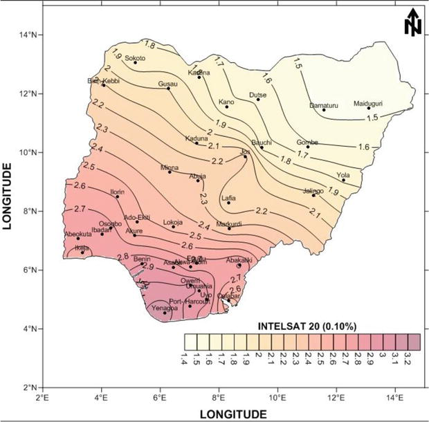
Figure 8.
A contour map depicting 0.1% rain attenuation (in dB) for typical Ku-band links on INTELSAT 20.
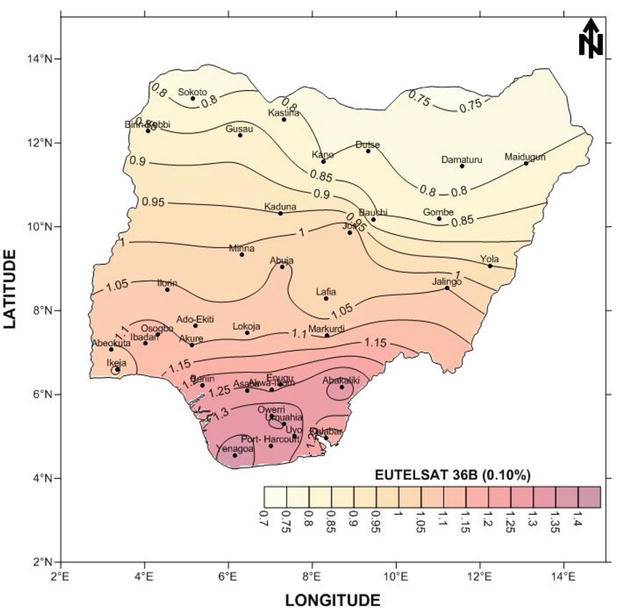
Figure 9.
A contour map depicting 0.1% rain attenuation (in dB) for typical Ku-band links on Eutelsat 36B.
Moreover, the persistent trend of INTELSAT 20 recording higher dB values compared to EUTELSAT 36B across the studied locations underscores the satellite’s susceptibility to signal disruptions induced by rainfall. For instance, in Yenagoa, INTELSAT 20 registers a dB value of 3.16, while EUTELSAT 36B reports 1.38 dB. This consistent pattern reinforces the importance of considering satellite-specific characteristics when designing satellite communication systems to mitigate the effects of adverse weather conditions and enhance overall network reliability.
In summary, these findings underscore the importance of considering both location-specific and satellite-specific rain-induced attenuation figures when optimizing satellite communication systems in Nigeria. High dB values signify areas prone to signal disruptions during rain, necessitating tailored solutions for reliable communication, while lower dB values indicate regions with higher signal resilience, aiding in the strategic deployment of communication infrastructure. These findings enable engineers and service providers to make informed decisions when optimizing satellite communication systems, particularly in regions with elevated rain-induced attenuation, to enhance network reliability and minimize signal disruptions. As observations and modeling studies consistently demonstrate a rise in heavy rains in various areas [38, 39], it is becoming evident that the future impact of climate change on communication systems will necessitate the development of more adaptive techniques to minimize signal disruptions at higher frequencies.
5. Conclusion
In conclusion, this research employed a comprehensive dataset of point rain rate distribution across various Nigerian locations to investigate rain-induced signal attenuation in satellite communication. The study focused on television receive-only (TVRO) stations in the Ku band, representing crucial endpoints of satellite communication links. The selection of these sites was strategic, ensuring a balanced representation of Nigeria’s diverse geographical and climatic features.
The findings revealed the significant impact of rainfall on signal quality, with southern regions consistently demonstrating high dB values, indicating heightened vulnerability to signal disruptions during heavy rainfall events. The comparison between two prominent satellites, EUTELSAT 36B and INTELSAT 20, consistently favored the former in terms of signal resilience during adverse weather conditions. Conversely, northern regions generally exhibited lower dB values, suggesting greater signal resilience during rainfall events.
These insights underscore the importance of considering both location-specific and satellite-specific factors when designing satellite communication systems. Robust infrastructure and strategic satellite selection are essential to mitigate the effects of rain-induced attenuation, ensuring reliable communication services across Nigeria’s diverse regions.
References
- 1.
Chebil J, Zyoud A-H, Habaebi MH, Rafiqul IM, Dao H. Analysis of rain fade slope for terrestrial links. Indonesian Journal of Electrical Engineering and Computer Science. 2020; 18 :896-902 - 2.
Hudiono H, Taufik M, Perdana RHY, Rakhmania AE. Telemetering of rainfall measurement results using 433 MHz wireless transmission. Journal Infotel. 2021; 13 (3):143-150 - 3.
Kestwal MC, Joshi S, Garia LS. Prediction of rain attenuation and impact of rain in wave propagation at microwave frequency for tropical region (Uttarakhand, India). International Journal of Microwave Science and Technology. 2014; 2014 :958498 - 4.
Alozie E et al. A review on rain signal attenuation modeling, analysis and validation techniques: Advances, challenges and future direction. Sustainability. 2022; 14 (18):11744 - 5.
Akinyemi GA, Falade JA, Kolawole LB. Estimation of rain attenuation at microwave bands in Nigeria. Журнал радиоэлектроники. 2018; 8 :3 - 6.
Chiang L-C, Wang Y-C, Liao C-J. Spatiotemporal variation of sediment export from multiple Taiwan watersheds. International Journal of Environmental Research and Public Health. 2019; 16 (9):1610 - 7.
Iheanyichukwu CA, Ike OA, Chukwuemeka CP. Investigating the impact of weather parameters on signal strength of satellite dish in Enugu metropolis. International Journal of Astrophysics and Space Science. 2020; 8 (2):11 - 8.
Oluwole O, Nicolae G, Olawale O, Oludele A. Mobile virtual laboratory in Nigeria. International Journal of Engineering and Computer Science. 2015; 4 :11417-11421 - 9.
Ojo JS, Akoma DB, Adetan O, Falodun SE. Analysis of rain-induced attenuation at Ku-V band using gamma drop size distribution model over a tropical region. Wireless Personal Communications. 2022; 124 :1-20 - 10.
Akobre S, Ibrahim M, Salifu AM. Rain rate and rain attenuation geographical map for satellite system planning in Ghana. International Journal of Computer Applications. 2020; 177 :34-45 - 11.
Adetan O, Oludare Fagbohun O. Analytical approach to critical diameters in raindrop size distribution in Durban, South Africa. Asian Journal of Advanced Research and Reports. 2018; 1 (1):1-8 - 12.
Obiyemi Obiseye O, Oluwumi A, Ibiyemi Tunji S. Recent update on one-minute rainfall rate measurements for microwave applications in Nigeria. International Journal of Wireless and Mobile Computing. 2015; 3 (3):33-39 - 13.
Ajayi GO, Ofoche EBC. Some tropical rainfall rate characteristics at Ile-Ife for microwave and millimeter wave applications. Journal of Applied Meteorology and Climatology. 1984; 23 (4):562-567 - 14.
Bryant GH, Adimula I, Riva C, Brussaard G. Rain attenuation statistics from rain cell diameters and heights. International Journal of Satellite Communications. 2001; 19 (3):263-283 - 15.
Adimula IA, Falaiye O, Willoughby A. Effects of rain on microwave and satellite communications in equatorial and tropical regions. Nigerian Journal of Physics. 2005; 17 (1):66-71 - 16.
Semire FA, Adekunle AJ, Abolade RO. Rainfall variability and its effect on communication link in southwestern Nigeria. International Journal of Big Data Mining for Global Warming. 2020; 2 (1):2050004 - 17.
Omotosho TV, Oluwafemi CO. One-minute rain rate distribution in Nigeria derived from TRMM satellite data. Journal of Atmospheric and Solar-Terrestrial Physics. 2009; 71 (5):625-633. DOI: 10.1016/j.jastp.2009.02.003 - 18.
Obiyemi OO, Ibiyemi TS. Experimental investigation of rainfall effect on digital satellite television reception in Nigeria: Initial results. In: 2014 IEEE 6th International Conference on Adaptive Science & Technology (ICAST). New York: Institute of Electrical and Electronics Engineers; 2014. pp. 1-4 - 19.
Ojo JS, Ajewole MO, Emiliani LD. One-minute rain-rate contour maps for microwave-communication-system planning in a tropical country: Nigeria. IEEE Antennas and Propagation Magazine. 2009; 51 (5):82-89 - 20.
Obiyemi OO, Omotosho TV, Oguntuase VA, Tijani I. Experimental assessment of cellular mobile performance along the railway corridor. Covenant Journal of Information and Communication Technology. 2015; 3 (2):12-22 - 21.
Lawal YB, Ojo JS, Falodun SE. Rain height statistics from GPM data for satellite communication systems in Nigeria. IOP Conference Series: Earth and Environmental Science. 2021; 655 (1):12038 - 22.
Lawal YB, Ojo JS, Falodun SE. Variability and trends in rain height retrieved from GPM and implications on rain-induced attenuation over Nigeria. Heliyon. 2021; 7 (10):e08108 - 23.
Lawal YB, Falodun SE, Ojo JS. Temporal evolution of atmospheric parameter-profiling on rain height over two geoclimatic regions in Nigeria. Journal of Atmospheric and Solar-Terrestrial Physics. 2020; 211 :105482. DOI: 10.1016/j.jastp.2020.105482 - 24.
Ojo JS, Ojo OL, Joseph-Ojo CI. Rain height information from TRMM precipitation radar and micro rain radar for radio communication studies in Nigeria. In: 2014 IEEE 6th International Conference on Adaptive Science & Technology (ICAST). New York: Institute of Electrical and Electronics Engineers; 2014. pp. 1-5. DOI: 10.1109/ICASTECH.2014.7068104 - 25.
Ojo JS. Rain height statistics based on 0 C isotherm height using TRMM precipitation data for earth-space satellite links in Nigeria. International Scholarly Research Notices. 2014; 2014 :798289 - 26.
Ojo JS, Olurotimi EO, Obiyemi OO. Assessment of Total attenuation and adaptive scheme for quality of service enhancement in tropical weather for satellite networks and 5G applications in Nigeria. Journal of Microwaves, Optoelectronics and Electromagnetic Applications. 2021; 20 :228-247 - 27.
Ojo J, Ajewole M, Sarkar S. Rain rate and rain attenuation prediction for satellite communication in Ku and Ka bands over Nigeria. Progress In Electromagnetics Research B. 2008; 5 :207-223 - 28.
Ojo JS. Estimation of cross-polarization due to rain over some stations in Nigeria. Annals of Telecommunications des télécommunications. 2012; 67 (5-6):241-245 - 29.
Orji PO, Chiemeka IU, Obiegbuna DC, Eze CM. Estimation of rain attenuation effect on radio wave propagation for broadband communication over Northern Nigeria. IOP Conference Series: Earth and Environmental Science. 2023; 1178 (1):12027 - 30.
Ajewole MO, Durodola OM, Ojo JS. Some aspects of rain effects on the performance of Ku-band satellite signals in Akure, Nigeria. In: 2014 XXXIth URSI General Assembly and Scientific Symposium (URSI GASS). Vol. 2014. Belgium: International Union of Radio Science; pp. 1-4 - 31.
Ometan OO, Omotosho TV, Adewusi MO, Akinwumi SA, Emetere ME, Boyo AO. Validation of rain attenuation models with experimental data at Covenant University, southwest, Nigeria. International Journal of Engineering Research and Technology. 2019; 12 :2111-2116 - 32.
Gbenga-Ilori AO. Effect of atmospheric impairments on ku-band free-to-air digital satellite television signals in Lagos state. Nigerian Journal of Technology. 2020; 39 (1):238-245 - 33.
Ibitokun J, Ojo JS, Ogunjo ST. Comparative study of worst month rain rate and attenuation statistics for satellite links in Nigeria. Radio Science. 2023; 58 (1):e2022RS007557 - 34.
Osita I, Nymphas EF. Characteristics of worst hour rainfall rate for radio wave propagation modelling in Nigeria. Meteorology and Atmospheric Physics. 2019; 131 :251-261 - 35.
Obiyemi OO, Afullo TJ, Ibiyemi TS. Evaluation of rain degraded digital satellite television reception in tropical regions. International Journal of Scientific and Engineering Research. 2013; 4 (12):790-799 - 36.
Ito C, Hosoya Y. The thunderstorm ratio as a regional climatic parameter: Its effects on different integration time rain rate conversion, rain attenuation, site-diversity and rain depolarization. In: URSI Proceeding, GA02 Pap. Vol. 181. Belgium: International Union of Radio Science; 2002. p. 2002 - 37.
ITU-RP. 618-13. Propagation Data and Prediction Methods Required for the Design of Earth-Space Telecommunications Systems. Geneva: Recomm. P. 618-13, P Ser. ITU-R, Int. Telecomm. Union; 2017 - 38.
Li Y et al. Strong intensification of hourly rainfall extremes by urbanization. Geophysical Research Letters. 2020; 47 (14):e2020GL088758 - 39.
Panthou G et al. Rainfall intensification in tropical semi-arid regions: The Sahelian case. Environmental Research Letters. 2018; 13 (6):64013