Open Access is an initiative that aims to make scientific research freely available to all. To date our community has made over 100 million downloads. It’s based on principles of collaboration, unobstructed discovery, and, most importantly, scientific progression. As PhD students, we found it difficult to access the research we needed, so we decided to create a new Open Access publisher that levels the playing field for scientists across the world. How? By making research easy to access, and puts the academic needs of the researchers before the business interests of publishers.
We are a community of more than 103,000 authors and editors from 3,291 institutions spanning 160 countries, including Nobel Prize winners and some of the world’s most-cited researchers. Publishing on IntechOpen allows authors to earn citations and find new collaborators, meaning more people see your work not only from your own field of study, but from other related fields too.
Heraion Teichos is a Thracian city in northwestern Turkey. By using modern technologies in this ancient city, the benefits that modern technologies can provide to archeological excavations have been investigated. The main purpose of this research is to understand how modern technologies can be used to increase accuracy and precision by examining the opportunities offered by developing technology in archeological studies. How these technologies were effectively integrated into the archeological field was examined, focusing on excavation methods, digital documentation, and architectural remains of the ancient city, especially three ancient medicine production pools. This research aimed to obtain strong results by integrating traditional excavation methods with modern technology. The Heraion Teichos example demonstrates how modern technologies can be used effectively in archeological research and constitutes an example that can guide similar studies in the future.
*Address all correspondence to: hcigdem.zagra@rumeli.edu.tr
1. Introduction
Archaeology is a scientific discipline that investigates historical remnants within the scope of ancient civilizations, cultures, and civilizations, evaluating objects belonging to past civilizations. In today’s context, archeological fieldwork plays a crucial role in uncovering cultural heritage assets that are under protection [1]. In this regard, it is essential to safeguard archeological sites, introduce historical values from past civilizations, and exhibit them. Therefore, meticulous efforts by the field team conducting archeological studies are necessary, with the precision required in documenting discovered objects and modeling the excavation site [2].
Technological advancements have made archeological fieldwork more effective and efficient. Various imaging techniques, especially terrestrial laser scanners, UAVs, and satellite imagery, are employed in field documentation. This allows cultural heritage assets to be digitally modeled in three dimensions, creating a permanent database that can be passed on to future generations. Furthermore, the transfer of acquired data on cultural heritage assets to digital platforms enables their three-dimensional virtual representation through multimedia tools. This situation establishes a lasting database for the transmission of past civilizations to future generations. Additionally, the use of orthophoto and 3D data facilitates the creation of restitution for the remains in archeological sites. In recent years, various studies have been conducted on three-dimensional modeling in archeological sites and the benefits of this method in digital environments. Akın and Erdogan [3] evaluated the effectiveness of unmanned aerial vehicle (UAV) Photogrammetry in archeological documentation at the Sarıkaya Roman Bath in 2022, emphasizing its potential contribution to the rapid and cost-effective documentation of historical artifacts in culturally rich regions like Turkey. Deniz et al. [4] utilized terrestrial laser methods to determine the physical characteristics of the stage wall of the Odeon structure within the ancient city of Kibrya. They highlighted that this method allowed for faster, easier, and more accurate survey drawings compared to classical methods.
In this study, an evaluation was conducted on the restitution and function of medicine production pools located in the ancient city of Heraion Teichos using 3D point cloud for exploring the different advantages provided by terrestrial laser technology. An interface program was utilized for documentation, incorporating terrestrial laser and 3D point cloud data. The assessment of pools and the surrounding wall remnants through terrestrial laser technology is a crucial stage in the restitution process. In this study, measurements were combined with the narratives of ancient authors regarding medicine production and the examination of architectural elements such as roof tiles, nails, and joints found during excavations. Literature reviews and on-site inspections were conducted to create restitution based on reliability analyses. However, archeological findings related to medicine production described in ancient written sources are very limited. Therefore, since there are no equivalents to the remains in the ancient city of Heraion Teichos, the contribution of this research to the field of archaeology is as significant as the underutilized terrestrial laser method.
2. Acropolis of ancient city of Heraion Teichos: Tekirdag
The ancient city of Heraion Teichos, located 10 km from Tekirdag province, is a Thracian city situated on the coast of the Sea of Marmara. Archeological excavations have been conducted in the region since the year 3000. The earliest architectural findings at the acropolis uncovered date back to the sixth century BC. and the latest cultural layer belongs to the first century AD [5].
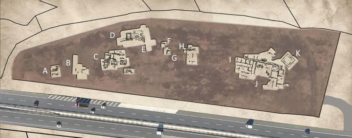
Figure 1I displays the prepared site survey plan of the revealed architectural remains at the acropolis of the Ancient City Heraion Teichos using terrestrial laser scanning. The findings from archeological excavations have led to the identification of two cult areas in the acropolis. The old cult area, located at the highest point of the acropolis, is dedicated to Hera/Cybele (Figure 1J). The “Hera/Cybele Sacred Area/Temple,” located northeast of the acropolis, was constructed with a stone cist wall and features a roof supported by wooden columns, with its existence dating back to the seventh century BC. Dedication coins from the second century BC. indicate the temple’s construction during the reign of Mostis II [6]. Over time, the temple was expanded, and additional spaces were particularly added after the second century BC. A large courtyard to the west of the Hera/Cybele Cult Area/Temple and four spaces to the north were interpreted as workshops related to weaving (Figure 1I). Excavations in these workshops have yielded clay weights and weaving looms. Hellenistic coins and terracotta pottery fragments were also found [7]. The Hellenistic tower was built in the thousand BC and is located northeast of the Hera/Cybele temple (Figure 1K). Part of the fortress walls and the northern gate were unearthed north of the acropolis (Figure 1D). The excavation finds lead sling bullets, bronze and iron arrowheads, and spear tips. Additionally, artifacts such as coins, terracotta figurines, and stamped amphora handles indicate that the fortress was built in the sixth century BC and was used until the period of Alexander the Great. In the Hellenistic Period, the eastern tower of the fortress gate was damaged, and the eastern part of the city wall was removed to be used as the Necropolis area (Figure 1E). Thracian tumuli and grave gifts were found in this necropolis. Excavations in these tombs have revealed finds such as the posthumous coin of Alexander the Great and Philip II, as well as terracotta vessels and figurine fragments [7]. After the destruction of the Hera/Kybele temple by fire, “Cult and Healing Center” was established in the west of the Acropolis (Figure 1A–C). Middle of the first century BC. This building complex existed until the end of the first century AD.
Figure 1.
A. Remains of Cult and Healing Center, B. A cult area/Temple to Zabasios, C. Remains of Cult and Healing Center: three pools, D. North gate and part of walls of the fortress, E. Necropolis, F. G. H. Control excavations, I. Workshops, J. Hera/Kybele Temple, K. Tower.
3. Use of medicine pools and medicine ovens in the “Cult and Healing Center”
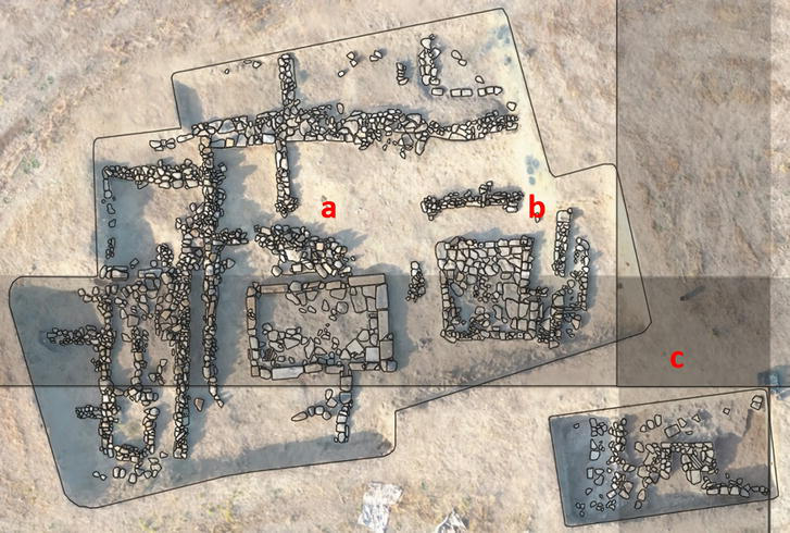
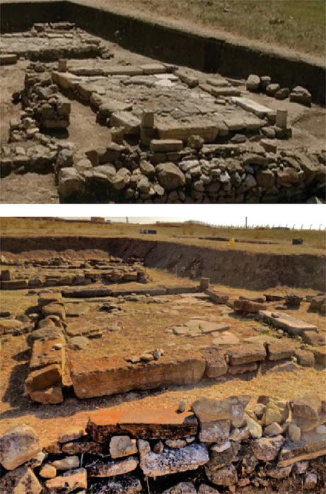
The ruins of the “Cult and Healing Center” located to the west of the acropolis are spread over a wide area [8, 9]. Building ruins were unearthed in the southwest temple (Figure 2a), cult area/temple to Zabasios (Figure 2b), in the east of these ruins, and three medicine production pools (Figure 2c), in the north-east of the temple, the north of the medicine pools there are two tandoor-shaped medicine ovens and made of clay sherds.
Figure 2.
The survey plan of the pools (a, b, c) located on the orthophoto.
In Figure 2, the orthophoto-based surveys of the three rectangular pools, which constitute the center for medicine production in the ancient city of Heraion Teichos, are presented. The geometry and dimensions of the pools are easily understood from the remains. Measurements provide accurate information about the size, depth, water circulation, and roof cover of the pools. The architectural details identified, together with archeological findings such as ancient authors’ books and pottery fragments, provided information about how pools and medicine ovens were used 2000 years ago.
There are three polls in the north of the “Cult and Healing Center’s” spread area. These pools were constructed with spolia stone and used for the production of medicine (Figure 1C). Various medicines have been produced using “Murex” in and around the pools. The Murex, belonging to the Muricidae family, possesses therapeutic potential due to its compounds. Traditionally known for the production of ancient purple dye, this marine shellfish also forms the basis for some rare traditional medicines used for thousands of years [9]. In addition, some comprehensive studies [10, 11, 12] have documented the use of marine mollusk shells as a nutrient or raw material (Figure 3).
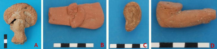
Figure 3.
Votive figurines. A. Female head, B. Ear, C. Ear, D. Arm.
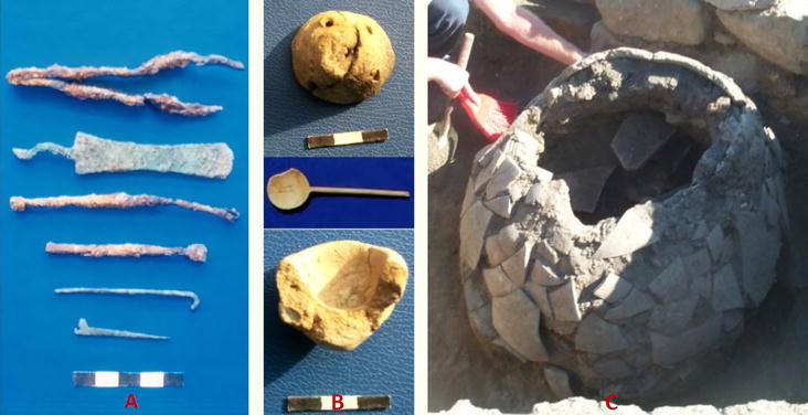
Ancient writers Plinius, Aristotales, Aristophanes, Vitrivius, and Plutarchos provide information about Murex. Its usage is quite diverse. It was used as a valuable textile dye (for the clothes of god/goddess statues, of kings), make-up, ink, and for painting [13]. The meat of Murex Brandaris (spikey sea snails), which is abundantly found in Heraion Teichos, was also considered a valuable food [14, 15, 16, 17, 18]. In the well-preserved medicine oven (Figure 4C), melted murex shells were identified. The first medical oven is located directly in the middle of the north side of Figure 2b, while the other oven is situated near the wall close to the pool in Figure 2a. Molten murex shells were found inside the ovens. Near the medical ovens and pools, various medical tools made of iron, lead, and bone such as forceps, spatulas, ear spoons, hooks, needles, etc. (Figure 4A) as well as medical vessels made of terracotta and bronze (Figure 4B) were discovered. The presence of diseased organs made of terracotta in this area (Figure 3) indicates that it was a center for both health and worship.
Figure 4.
A. Medical utensils (forceps, spatula, ear spoon, hook, needle) B. Clay strainer, balm container, and spoon made of bone C. Murex oven.
There are three varieties of Murex in Anatolia: Murex Trunculus, Murex Brandaris, Murex Haemostoma. All of these varieties were used as textile dyes. Purple-dark red colored textile products were obtained with this dye, called “purpura” in Latin. Amethist color was obtained by using three types of snails together. Color tones of purple and red were made by mixing honey, water, algae, and urine.
The textile dye must have been obtained from Murex in Heraion Teichos. Because many loom weights and spindle whorls were found during excavations. Small finds in the workshops to the west of the temple of Hera/Kybele indicate that textiles were produced. The Tumulus tomb of King Kersobleptes is 3 km far from Heraion Teichos. The king was buried here wearing his purple-colored dress. However, the three pools we examined cannot be paint pools. To obtain dye, Murexes are kept in warm water with their shells.
Murex flesh and shells are separated into three medicine-making pools. Medicine was made by melting murex shells in the ovens north of the pools. According to the ancient writer Plinius, murex was pressed, burned, and melted, then mixed with lard and honey and applied to the skin as an ointment against burns. This burn cream was called “όζνγγία.” Melted murex was ground to make a powder called κηρύκες, which was used to clean teeth. In two pools in Heraion Teichos (Figure 4a, b), murex flesh was separated in the pool, and the shells were melted in the nearby furnaces to make medicine. Pools a and b have roofs over them because they work under the sun for long periods of time. The ancient writer Xenocrates says that murex meat flesh was tied to swollen muscles and used in treatment. The meat separated in these pools was probably used in this way.
The flesh, secretion, and also shells, of Murex have been used as medicine. Ancient writer Hippocrates says that its secretion solves digestive problems. Plinius said that its secretion was useful against some types of poison. The third pool, which is smaller than the other, has no roof (Figure 4c). Cooking pots and traces of ash found around this pool suggest the making of different medicines, especially those that require cooking. For example, the ancient writer Dioskurides said that deep-fried murex flesh was a cure for baldness. Therefore, the third, smaller pool must have been used for processing murex flesh. For example, a swollen liver was treated by soaking the flesh of Murex in vinegar. The flesh separated in other pools was probably washed in this small pool and then used for cutting, cooking, and storage. A pithos (storage container) buried in the ground was found in one of the chambers. To the west of the pools. A pottery sherd with an inscription “ɅOYΦΑΡΜΑ” (farma = medicine) written on it also indicates that medicine was stored.
Laser scanning technology used in the form of LIDAR, which stands for Light Detection and Ranging, is an active remote sensing technology that produces high-accuracy three-dimensional (3D) data using a laser beam [19]. Laser scanning technologies involve the emission of laser beams onto a surface or area through a laser scanning device, enabling the acquisition of three-dimensional (3D) point cloud data for that space. The inception and design of this technology have been made possible through interdisciplinary collaborations among electrical, computer, geodetic, and photogrammetric engineers. Leveraging the characteristics of high-power laser radiation, short pulses, or modulation, terrestrial laser scanning proves advantageous for measurements [20, 21].
Research in the field has been focused on accuracy analysis, and calibration reports elucidating the relationship between reflected laser intensity and surface reflection, factors influencing the accuracy of laser scanners, employing the Lambert reflection model [22]. Terrestrial laser scanning technology, with a measurement accuracy of 99.9% (±2 mm) in complex geometries, offers numerous advantages, including cost reduction, workforce efficiency, time savings, versatile data utilization and sharing, obtaining detailed and comprehensive data in a single session for transformative use, and enabling measurements in hazardous or inaccessible areas where conventional measurement becomes challenging [23].
4.1 3D point cloud image
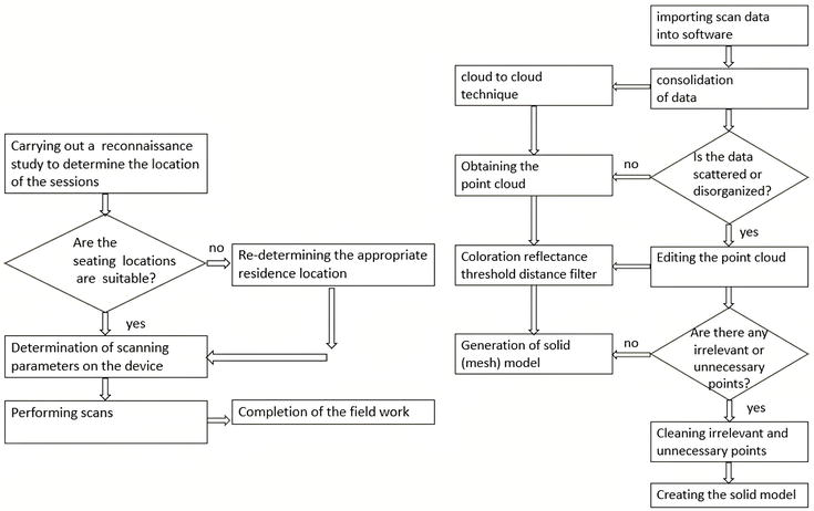
Laser scanning technology used in the form of LIDAR, which stands for light detection and ranging, is an active remote sensing technology that produces high-accuracy three-dimensional (3D) data using a laser beam [24]. Terrestrial laser scanners can generate a point cloud with X, Y, and Z coordinates for any desired object. From the obtained point cloud, a 3D model of the object can be created [25]. Laser scanning technology is a system that enables the representation of object surfaces with 3D coordinates. Essentially, the distance between the scanner and a specific point on the object’s surface is determined with high accuracy by measuring the round-trip time of the laser signal [26]. According to the summarized fieldwork presented in the diagram on the left side in Figure 5, session locations and scanning parameters are crucial.
Figure 5.
Fieldwork workflow diagram (left) workflow diagram for Scene (right) [27].
4.2 Orthophoto
Laser scanning technology used in the form of LIDAR, which stands for Light Detection and Ranging, is an active remote sensing technology that produces high-accuracy three-dimensional (3D) data using a laser beam [24]. An orthophoto is an aerial photograph or satellite image that corrects for terrain elevation, camera tilt, and lens distortion. It produces a map-like image, enabling accurate measurements of distances, angles, and areas. Its applications include engineering, planning, design, and map production. Data sources include aerial photographs and satellite images. The quality of an orthophoto depends on factors such as operator skill, parameter selection, and the digital elevation model used. In particular, the planimetric density of the digital elevation model controls the accuracy of the surface model [28]. In Figure 5, the diagram on the right side schematically illustrates the workflow in the Faro Scene software.
4.3 Use of orthophoto in archeological sites
LIDAR scanner methods are divided into two: TLS (Terrestrial LIDAR System) and ALS (Airborne LIDAR System) [29]. In general, TLS (Terrestrial LIDAR System) terrestrial LIDAR systems are used for modeling in archeological excavation sites. In tasks such as scanning objects containing complex geometries, scanning surfaces from a single point may not provide accurate and usable data. In such cases, scanning should be done with rays sent from different points, and then these scans should be combined and transferred to the geodetic coordinate system. Computer aided design (CAD) software is used to integrate scanning data with spatial data [23].
5. Documentation of Heraion Teichos Ancient City with terrestrial laser scanning
For the production of 3D models, the laser scanner device used is the Faro Focus M 70 model, manufactured by the laser scanner manufacturers Faro, with its basic technical specifications presented in Table 1.
Heraion Teichos Ancient City covers an area of approximately 26,954 m2, and a total of 188 scans, capturing 1,446,050,556 points, were conducted at seven different locations. The scans were merged with a precision of 2.95 mm using the cloud-to-cloud method in the SCENE 2022 program. Subsequently, they were overlaid onto images to create a point cloud. The scans were performed on sunny days, specifically on October 5–8, 2023, using a laser scanner mounted on a tripod.
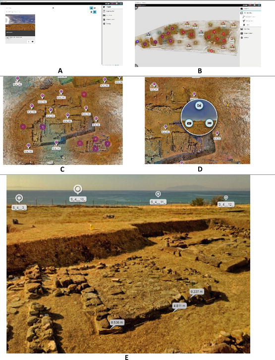
After the data collection phase in the field, the acquired data in “.fls” format is transferred to the Scene program, which is Faro’s software, and the process of coloring the points is carried out. Following the completion of the coloring, the data undergoes the referencing and merging process. Subsequently, point clouds are generated. Two-dimensional orthophoto images are obtained from the created point clouds in the form of plans, cross-sections, and elevations. Additionally, for the support of photogrammetric work, the point cloud is exported in pts. format. The data obtained from the Scene software, with its high resolution and byte size, complicates the end user’s work and data flow. Therefore, to facilitate data transfer to the end user and enable the user to work with low bytes, the data exported from the Faro Scene software is converted into the Scene 2go program, whose working principle is summarized in Figure 6.
Figure 6.
The user interface of the Scene 2go program.
The data transferred to the end user enables two separate versions, one for the Mac and one for the Windows operating system, within a folder. Figure 6A is the project entry screen, providing access to all session locations and site plans, as shown in Figure 6B through the photograph on the left. The session icons include elevation classification. This classification is expressed with a color scale ranging between blue and red. The location information in red indicates higher elevations, while approaching the blue color tone signifies a lower elevation. In Figure 6C, the site plan makes our session locations more distinct, and the number of sessions in that area can be clearly seen. When clicking on the location marker in Figure 6D, visual data of the scanned area, point cloud data, and session recording information can be accessed. Figure 6E shows the visual data and panoramic view of the session that we access when clicked. Due to the presence of point data in the background of the photo, measurements can be made accurately using the points, and the area can be calculated correctly.
6. Restitution proposal of medicine pools and medicine furnaces in the “Cult and Healing Center”
For the restitution in the archeological field, a detailed on-site examination is essential. The original construction traces on the remnants of the structure and the positions of the fallen stones assist in determining their original locations. When evaluated from this perspective, terrestrial laser scanning enables this examination through 3D point cloud and matched photographs, supporting the on-site investigation. Additionally, the readily accessible data facilitates the tracking of traces.
In the first century BC, ancient pools were found along the Mediterranean and Aegean coasts. Although their sizes and functions vary, most facilities can be easily identified by the presence of fairly standardized pools. Usually constructed with square or rectangular walls, often partially collapsed or protruding, these pools are observed to be coated with opus signinum, a waterproof mortar mixture of lime and small tiles or ceramic particles. Rubblestone is commonly used as a building material. The shell residues within the pools indicate that these facilities could be used for cleaning, washing, or extracting shells and dyeing clothes [31]. Additionally, Vitruvius notes that these shells were broken into pieces with iron tools and referred to as “tire” due to the odor in cities engaged in dye production [32]. Research on ancient pools suggests that these structures could be associated with functions such as dye production, raw material processing, and the production of food and medicine.
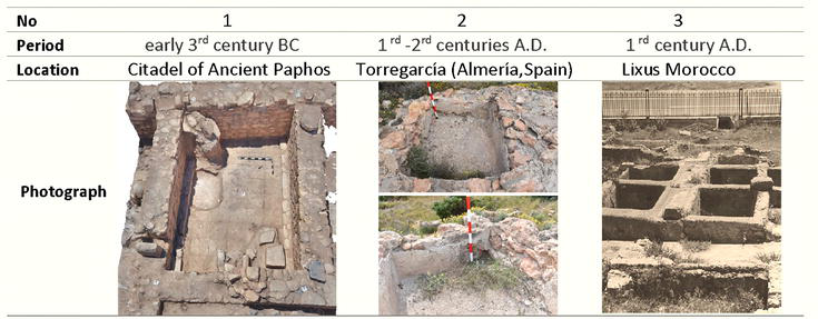
In Figure 7, similar examples of recent periods are examined. The pool numbered 1 in Figure 7 was uncovered in 2016 by removing collapsed roof tiles and wall rubble, revealing a layer of purple shells. After the analysis of these layers, it was suggested that the pool was used for the production of purple dye. After removing the layer of purple shells, brick tiles on the floor of the pool were revealed [33]. In the area where the pool numbered 2 in Figure 7 is located, Roman ceramics and a layer of shells were found. Laboratory analysis of the shells indicated that Hexaplex trunculus dominated with a percentage of 93%, and this type of seashell was noted to be the best species for producing purple dye [34]. The pool numbered 3 in Figure 7 is reported to have been used as a fish salting facility. These areas, called Catariae, can be found outdoors or in enclosed spaces with doors and windows for ventilation. These pools are often used as a section where marine resources are washed and cleaned or where shells and dyes are prepared. Sometimes, they are used to reduce the structure of sauces, increase the temperature of the dye mixture, or obtain salt from seawater. Additionally, at sites with cetariae in the Northwest Maghreb, murex/purpura shells are frequently observed. These seashells are likely used in the production of various salted sauces in the region, along with other types of seashells such as clams and oysters (Figure 8) [31].
Figure 7.
Comparative period analysis.
Figure 8.
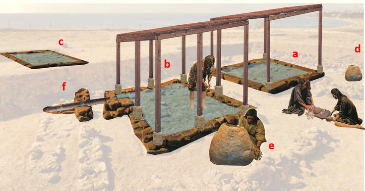
Illustration of ancient pools (a, b, c), murex ovens (d, e), and water pipe (f).
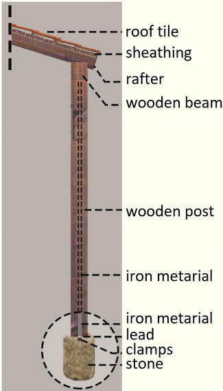
Measurements provide precise information about architectural details. The width of the pool in Figure 4a ranges from 4.80 to 6.75 m, with a maximum depth of 0.60 m. The width of the pool in Figure 4b ranges from 4.80 to 4.70 m, with a maximum depth of 0.30 m. The width of the pool in Figure 4c ranges from 2.10 to 2.50 m, with a maximum depth of 0.40 m. In some corners of the pools, there are cubic and cylindrical column bases with a hole in the middle, approximately 0.33 m in height and 0.23 m in width. Stone column bases belong to ancient buildings. In fact, old architectural material (spolia) was used in the pools and all the structures around them such as an architrave fragment, an inscribed sill, etc. Additionally, the roof of the pool on the west side shows that it is supported by four columns, and the roof of the pool on the east side is supported by eight columns.
During the excavation, a significant number of iron nails were found beneath the tiles, indicating a wooden structure. The roofs covered with tiles were likely transported by stone-based, wooden columns, as evidenced by the column bases with holes in the corners of the pools. Wooden columns should have been attached to these stones with a metal rod through the round holes in the middle. Literature research also supports this [35]. Bases were found at the four corners of the western pool, but only one has survived to the present day (Figure 9). The base, wooden post, and details of the roof covering the pool are depicted in Figure 10. It is believed that the ancient pools had roofs covered with Laconian-type tiles, measuring approximately 50x35x4cm, with dimensions similar to those of the pools.
Figure 9.
Stone base (above – 2006, below – 2023).
Figure 10.
Wooden column detail.
On the western side of the pools, there are adobe structures with rubble stone foundations. It is understood that these structures contain frescoes in their interiors. In the western chambers, a large number of murex shells and pithos buried in the ground were found in one of the chambers. These chambers are likely storage areas for drugs and drug materials. In the northern chambers, there were baked clay pots and numerous lamps. The lamps suggest that activities continued in the areas around the pools until late hours.
The water brought to the pools was partially conveyed over the remains of the Hera/Kybele Temple through terracotta water pipes (outer diameter 10.5 cm, wall thickness 2 cm) inclined westward (Figure 8f). The clean water, passing over the remains of the Hera/Kybele Temple, reaches the pools with an approximate elevation difference of 6 meters. At the point where the clean water pipes continue in front of the temple ruins, the water is filtered by passing through a jar, and a round marble cover is placed on top of the jar. To the east of this jar, a stone trough has been found. The opening here should have been made to adjust the water pressure and/or to clean large stones that may have mixed into the water.
In addition to the terracotta water pipes that conveyed clean water from the Hera/Kybele Temple in an east-west direction to the medicine pools in the west of the acropolis, it has been determined that there are other clean water pipes extending in the north-south and west directions. In a borehole in the center of the acropolis, it can be observed that the water, filtered through a jar, is connected to the south with two pipes and to the west with one pipe. The fact that the pipes connecting in the north-south direction also connect to the east-west water pipes indicates that almost the entire acropolis was involved in health-related activities.
The entry point of the water to the small pool, which was uncovered in 2023, has been determined to be from the east, similar to the eastern one of the two adjacent pools that received water directed to the west. It is observed that the wastewater from this small pool, located southeast of the two large pools, is directed to the west and connected to the wastewater channel made of large flat stones, which is directed south like the other pools. Traces from the structure, literature research, and period examples support the proposed restoration of the ancient medicine pool (Figure 8).
Antique cities are archeological areas with extensive surface areas, and the remnants of structures and other cultural artifacts are often found scattered in these areas. These cities encompass large architectural complexes constructed in different periods throughout history. In this study, terrestrial laser scanning (TLS) and three-dimensional point cloud data have facilitated the continuous tracking of architectural remains and the understanding of material continuity on a digital platform without physically traversing distances. The architecture of the ancient pools in the Heraion Teichos Antique City, their relationship with each other, and the connections between the water distribution pipes and the pools in the city were analyzed and interpreted using the Scene 2go program, where meshed photos based on three-dimensional point cloud data were observed. Moreover, due to the detailed information provided by TLS and three-dimensional point cloud data on the material, texture, dimensions, shape, and deterioration of archeological remains, a comprehensive understanding was achieved. These data facilitated undeniable convenience in creating scaled and measured illustrations for the restitution of structures.
With terrestrial laser scanning (TLS), the structures in the Heraion Teichos Ancient City have been rapidly and accurately scanned, resulting in time and labor savings compared to traditional measurement methods. The obtained data can be utilized for the detailed examination of the topographic structure of the area, understanding terrain changes, elevation differences, and other topographic features. The high-precision point data can determine the geographical location of the archeological site and facilitate coordination between different data sets. Archeologists can better understand the overall structure of the area before excavation with the 3D data obtained, allowing them to optimize excavation strategies.
In conclusion, precise scanning data provides a more comprehensive, fast, and effective research and documentation process in archeological sites. This allows researchers an opportunity for more in-depth study and contributes to the preservation of documented (digital documentation) historical structures for future generations.
This study was supported within the scope of the Istanbul Rumeli University Scientific Research Projects under the project number “BAP2023001.” We would like to express our gratitude to the Istanbul Rumeli University Scientific Research Commission, to Sahin Tas, a graduate student at Istanbul Rumeli University, for his contribution to the survey drawings, and to Lidart Company.
References
1.Alptekin A, Celik MO, Dogan Y, Yakar M. Illustrating of a landslide site with photogrammetric and LIDAR methods. In: El-Askary H, Karakus M, Abiddin Erguler Z, Chamine HI, editors. Research Developments in Geotechnics, Geo-Informatics and Remote Sensing. Cham: Springer International Publishing; 2022. pp. 303-305
2.Demirkesen AC, Ozludemir MT, Demir HM. Preservation of historical and cultural heritage in the case of Cappadocia and the powers and responsibilities of survey engineers in these processes. In: TMMOB Chamber of Surveying and Cadastral Engineers 10th Turkish Mapping Scientific and Technical Congress; 28 March–1 April 2005; Ankara. pp. 1-10
3.Akın ES, Erdogan A. Documentation in archaeological sites with unmanned aerial vehicles (UAV): Example of Sarıkaya Roman Bath (Therma basilica). Suleyman Demirel University Institute of Science and Technology Journal. 2022;26(3):335-343
4.Deni̇z S, Oktem S, Kirbas I, Tarkan D. Use of spatial/terrestrial laser scanners in determining the physical features of archaeological sites: Example of the stage wall of the Odeon structure of the Ancient City of Kibrya. Mehmet Akif Ersoy University Institute of Science and Technology Journal. 2017;8(Suppl. 1):211-217
5.Atik N. The magnificent Temple of the Thracian mother goddess in the Ancient City of Tekirdag Heraion Teichos. In: Ureten H, Sina A, editors. Tekirdag. A Gift to the 100th Anniversary of its Establishment. İstanbul: Karadeniz Book Ltd. Sti; 2023. pp. 9-14
6.Yagız MO. The coins of the thracian king mostis. In: Fourth International Forum of Calligraphy,Writing and Inscriptions in the World throughout the Ages Coins in the World; 16-18 March 2009. Alexandria: Abgadiyat; 2010. pp. 65-70
7.Atik N. Thracians and the Ancient City of Heraion Teichos in Tekirdag. Archeology and Art. 2016;152:75-86
8.Atik N. Tekirdag Karaevlialtı ancient Heraion Teichos excavation. In: T.R. Ministry of Culture and Tourism XLI, International Excavation Research Archaeometry Symposium; 23-27 May 2022. Denizli, Ankara: Ministry of Culture and Tourism; 2019, 2022. pp. 369-378
9.Atik N. Two important monuments in the ancient city of Heraion Teichos: The sanctuary of Hera/Kybele and the sanctuary of the god of health. In: Thirteenth International Congress of Thracology Kazanlak, 3-7 September 2017. Vol. 2. Sofia: Ancient Thrace: Myth And Reality; 2022. pp. 21-30
10.Benkendorff K, Rudd D, Nongmaithem BD, Liu L, Young F, Edwards V, et al. Are the traditional medical uses of Muricidae molluscs substantiated by their pharmacological properties and bioactive compounds? Marine Drugs. 2015;13(8):5237-5275. DOI: 10.3390/md13085237
11.Shackleton JC, Van Andel TH. Prehistoric shore environments, shellfish availability, and shellfish gathering at Franchthi, Greece. Geoarchaeology. 1986;1(2):127-143
12.Karali L. The seashells of Maroulas, Kythnos. In: Sampson A, Kaczanowska M, Kozlowski JK, editors. The Prehistory of the Island of Kythnos (Cyclades, Greece) and the Mesolithic Settlement at Maroulas. Krakow: The Polish Academy of Arts and Sciences; 2010. pp. 147-149
13.Yavsan C. Sea Shells Found in Chalcolithic Smintheion (Gulpınar) Excavations. Çanakkale: Troia Foundation Publications; 2013. p. 111
14.Eyuboglu O, Okaygun I, Yaras F. Woll Dyeing with Natural Dyes. 1st ed. İstanbul: Ozkur Publisher; 1983. p. 138
15.Keller O. The Ancient Animal World. 2nd ed. Vol. 2. Leipzig: W. Engelmann; 1980. p. 568
16.Herrmann F. Milesian Purple. Istanbul News. 1975:141-147
17.Rackham H. Pliny's Natural History. Vol. 1-5, 9. London: Harvard University Press; 1949-1954. p. 230
18.Schneider. Realencyclopedia of Classical Antiquity. Stuttgart: Metzler; 1959
19.Gungor M. Examining the use of terrestrial laser scanners in archaeological sites. Turkey Lidar Magazine. 2022;4(2):85-90
20.Ready JF. Industrial Applications of Lasers. Elsevier; 1997. p. 588
21.Wehr A, Lohr U. Airborne laser scanning—An introduction and overview. ISPRS Journal of Photogrammetry and Remote Sensing. 1999;54(2-3):68-82
22.Hancock JA. Laser intensity-based obstacle detection and tracking [PhD. thesis]. Pittsburgh: Robotics Institute, Carnegie Mellon University; 1999
23.Reshetyuk Y. Investigation and calibration of pulsed time-of-flight terrestrial laser scanners [PhD. thesis]. KTH, School of Architecture and the Built Environment (ABE), Royal Institute of Technology (KTH); 2006
24.Erisir Z. Classification of LIDAR data with point-based classification method [thesis]. Yıldız Technical University, Institute of Science, Department of Surveying Engineering, Remote Sensing and GIS Program; 2015
25.Elkhrachy I, Niemeier W. Optimization and strength aspects for geo-referencing data with Terresterial laser scanner systems. In: 3rd IAG7/12th FIG Symposium; 22-24 May 2006; Baden. pp. 1-10
26.Akyol O, Duran Z. Low-cost laser scanning system design. Journal of Russian Laser Research. 2014;35:244-251. DOI: 10.1007/s10946-014-9419-2
27.Yakar I, Çelik MO, Sng H, Bilgi S. Comparison of different software in cultural heritage documentation studies: Obelisk (Theodosius obelisk) example. Geomatics. 2021, 2021;6(3):217-226. DOI: 10.29128/geomatik.761475
28.Ayhan E, Erden O, Atay G, Tunc E. Digital orthophoto generation with aerial photos and satellite images and analyzing of factors which affect accuracy. In: Shaping the Change, XXIII International FIG Congress. Munich; 2006. pp. 552-565. Available from: https://www.oicrf.org/documents/40950/43224/Digital+orthophoto+generation+with+aerial+photos+and+satellite+images+and+analyzing+of+factors+which+affect+accuracy.pdf/7f030532-73c5-081d-3c45-0c5edec69c28?t=1510174503870
29.Polat N, Uysal M. A general overview of air laser scanning system, application areas and software used. Afyon Kocatepe University Journal of Science and Engineering Sciences. 2016;16(3):679-692
30.Tekin E. Lidart Education and Construction Industry. İstanbul: Trade Limited Company; 2023
31.Trakadas A. Fish-Salting in the Northwest Maghreb in Antiquity: A Gazetteer of Sites and Resources. Oxford: Archaeopress Publishing Ltd; 2016. p. 177
32.Vitruvius P. Vitruvius Architectura (Illustrated). US: Amazon Digital Services; 2021. p. 409
33.Lacovou M, Mylona D. Purple Dye Production under Royal Management: Evidence from the Cypro-Classical Citadel of Ancient Paphos Notebook of the Center for Cypriot Studies. Vol. 492019. pp. 167-178. DOI: 10.4000/cchyp.586
34.Lopez-Medina MJ et al. Non-invasive prospection techniques in the Cabo de Gata-Níjar Natural Park (Almería, Spain): Torregarcía’s site. Land. 2023;12(2):304-326. DOI: 10.3390/land12020304
35.Tokoz OD, Ipekoglu B. Anastelosis of Greco-Roman temple remains in Western Anatolia: Principles, implementations and assessment. Conservation and Management of Archaeological Sites. 2020;22(1-2):1-37. DOI: 10.1080/13505033.2021.1882094
Written By
Hatice Cigdem Zagra Oz and Nese Atik
Submitted: 26 January 2024Reviewed: 01 February 2024Published: 18 April 2024