Open Access is an initiative that aims to make scientific research freely available to all. To date our community has made over 100 million downloads. It’s based on principles of collaboration, unobstructed discovery, and, most importantly, scientific progression. As PhD students, we found it difficult to access the research we needed, so we decided to create a new Open Access publisher that levels the playing field for scientists across the world. How? By making research easy to access, and puts the academic needs of the researchers before the business interests of publishers.
We are a community of more than 103,000 authors and editors from 3,291 institutions spanning 160 countries, including Nobel Prize winners and some of the world’s most-cited researchers. Publishing on IntechOpen allows authors to earn citations and find new collaborators, meaning more people see your work not only from your own field of study, but from other related fields too.
To purchase hard copies of this book, please contact the representative in India:
CBS Publishers & Distributors Pvt. Ltd.
www.cbspd.com
|
customercare@cbspd.com
The populations in the EBO forest in Cameroon, mainly the Banen tribe with 4 clans in about 47 villages, had to leave their homes and communities behind in the years 1960s because of post-independence war. The identification and mapping of their cultural heritage is today a step to advocate for the government to facilitate their return in their customary land. Participatory mapping techniques use with their consent, of their cultural heritage, was done to understand their customary land in which they participated in the data collection and validation. The results show that the resettlement efforts, of the Banen people, often claimed since the 1970s is to prioritize immediate needs to return to their ancestral land. The Cameroon government, who had earlier proposed the area for conservation because of its biodiversity richness, has not seen the need to reinstall these people in an area of intact forest. These communities, through participatory mapping, have addressed the loss of their cultural heritage and need for careful planning and coordination. Since cultural heritage plays a vital role in defining the identity of displaced “Banen” communities, they look disconnected. It is crucial for the government to recognize and respect their cultural identity to ensure that their heritage is preserved.
AJEMALEBU Self Help, Ebo Forest Research Project, University of Ngaoundere, Limbe SW, Cameroon, Cameroon
*Address all correspondence to: ndjounguep@gmail.com, info@ajesh.org
1. Introduction
Cultural heritage issues for the resettlement of displaced populations in the Ebo forest area are a challenge because they link to loss of heritage, cultural identity, competing priorities, intercultural dynamics, and lack of resources and expertise [1]. There is a need for proper planning that incorporates cultural heritage into legal frameworks, policies, and development plans to ensure its protection and integration within resettlement initiatives.
The unstable political situation of African countries during the year 1950 brought a lot of displacement among rural and urban populations in search of peaceful areas. Colonialism has to ensure population considered its ideology before independence. Most of these cause civil war in different countries. The case of Cameroon, a central African country was unique. A civil war with some warriors who declared war against colonialism. In order to gain their freedom, the fight was mostly in the forest where France had to track what was named “les maquisar.” The leaders were seen by the transition state at the time as wanted and any of them that were caught were killed in public space. As the war between the “maquisar” and the colonialism/state was going strong, the state saw the need to evacuate people from villages where the warriors were hiding. The proposed displacement was for a period of time but till date, the new government never thing how these people, could regain their ancestral home.
Within this situation, the area where people have been displaced has become, after 50 years, a virgin forest. Here, a lot of interest started growing from the state and other international conservationists. The example of the Ebo forest in Cameroon is more expressive. While the displaced population was brought to resettle in some areas, the Ebo forest, the land of “Banen” and “Bassa”, was proposed for a protected area (PA) in 2006 because of the presence of highly endangered species (primates) in the landscape. While research where still going on, the classification of the area as a protected area has not until 2019, been approved by the state. In early 2020, the proposed area for PA was transferred for logging concession by the state. These communities lobby for coveting of their ancestral home for forest exploitation.
This poor land use planning method, is against the cultural rule and sustainable development of local communities. Land use planning through participatory mapping, is crucial for environmental, social, and economic development. It is also essential for the empowerment of local people and for securing land tenure and is an instrument for securing consistency, continuity, and alignment between national and local development objectives with respect to the use of natural resources, investments in infrastructure, production, and conservation.
Emerging conflicts/overlapping land tenure, in the Yabassi key biodiversity area, reduce the effective impact of the cultural heritage and sustainable investments by local communities. Land use planning and secure tenure are seen as foundations for Cameroon’s Rural Development Strategy, and also a promising tool to reconcile such interests in such a way as to redress the balance between global, national, and local priorities. Therefore, there is a need for methodological integration and the development of new techniques for land use amelioration. Hence, the concept of Free Prior Informed Consent (FPIC) especially by the villages and communities involved.
Cameroon’s 2011 land use planning law provides a supportive framework for modern, inclusive, multi-disciplinary, and cross-sectoral planning [2, 3, 4, 5, 6]. Principles defined by law are broadly in line with the generally accepted principles for land use planning though they lack clarity on aspects of obtaining free prior informed consent (FPIC), gender equality, and recognition of customary tenure. Although the legal framework in Cameroon does not explicitly call for the consent of indigenous or local communities with regard to development on their lands, numerous legal instruments and processes form the institutional basis for the free, prior, and informed components of FPIC. For example, the Framework Law on Environmental Management 1961 calls for local stakeholder consultations within environmental impact assessments, and the Orientation Law for Land Use Planning and Sustainable Development 2012 calls for local participation in all decisions regarding land allocation and use.
Participatory land-use planning is an important step in ensuring that local communities are engaged in negotiating development schemes and that such negotiations are transparent. Local land use plans prepared through a well-informed, participatory process are therefore proposed as a potential building block for the implementation of development strategies, and sustainable and equitable rural development contributing to progress toward the Sustainable Development Goals that will best meet the needs of the people [2, 5, 6].
2. Cultural heritage in the Ebo forest area and process of integrating local knowledge in the mapping
2.1 Ebo forest area and village’s cultural heritage
It’s comforting to know that the Ebo Forest’s communities have a rich cultural legacy and value derived from their ancestral setting. Many of these settlements were removed during the second part of the twentieth century, around the time of Cameroon’s independence, and their early history can only be conjectured based on oral traditions that are not well documented. Many of the communities have been regrouped with some other historic villages to form new groups.
Despite the fact that some villages have moved out of the Ebo forest, many members of the community still have strong personal ties to it and regard it as ancestral territory. Prior to Christianity, each family was said to have a sacred site in the forest, marked by a stone or a tree, where they performed their religious rituals. At least one species of crinum lily plant was said to be used for rituals at each location. Prior to Christianity, each family was said to have a sacred site in the forest, marked by a stone or a tree, where they performed their religious rituals. At least one species of crinum lily plant was said to be used for rituals at each location.
On February 23, 2022, the Association of Chiefs of the Ebo Forest Area gathered to remind themselves that the cultural values present in their land tenure area are those that connect them to their ancestral origin and that these values must be preserved and passed down from generation to generation. These values include cultural sites (Sacred forests, Sacred trees), ancient buildings, monuments, tombstones, artifacts, cemeteries, and other cultural sites that affirm their identity as a people while also providing a comprehensive framework for the preservation of their cultural values, beliefs, and way of life.
On the one hand, the chiefs taught to better preserve these cultural values, and they should be identified and rehabilitated, on the other hand, the best way to preserve these values is to collect and share information in order to integrate cultural governance into natural resource management policies for the Ebo landscape communities’ sustainable development. Figure 1 shows the characteristics of cultural heritage.
Figure 1.
Cultural heritage structure for resettlement villages.
3. Process of integrating local knowledge in the mapping of cultural heritage
The “Mapping for Rights” method developed by the Rainforest Foundation and supported by MINEPAT in Cameroon is indicated in the process. It is a 7-step process: (1)identification and Free Prior Informed Consent (FPIC), (2) prospection, (3) Training of the local mappers, (4) Data collection by the local mappers, (5) Data treatment, (6) validation of the data, and (7) transfer of data [2, 6, 7].
In addition, to obtain all necessary information, we used: focus group (to collect information on health, education, village organizational structure and history, and land tenure), semi-structured questionnaires with all households per village (to obtain socio-economic data (population, numbers of birth/death for the year 2022, gender, age distribution of the population within and outside the community, types of farming activities, other livelihood activities like NTFPs exploitation, annual output, consumption rate and transportation means, etc.).
Community sensitization meetings were held to identify sensitized communities about land tenure rights and the role of local communities in the documentation of their land uses in order to inform regional and national land use plans. The local governance of land and resources was done using villages’ Venn diagram and problem tree. Spatial data were also collected using a Garmin GPS.
3.1 Participatory mapping of community’s cultural heritage within the Ebo forest landscape
The participatory mapping strategy involved the facilitator bringing the stakeholders or representative groups together to perform the mapping exercise. For this to be done, the village had to freely consent, support, and also agree to participate in the process. The strategy involved the following major steps [8].
3.1.1 Information
In which the community leaders (key stakeholders) were briefed on the project, its importance, methods, expectations, and uses. This step sought to inform the major stakeholders on the project and obtain their approval and commitment. When this was done, we then moved to the next step which was to organise stakeholder sensitization meeting.
3.1.2 Prospection
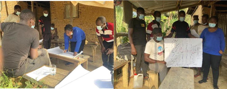
The community as a whole was presented to the project, its objectives, approach, and importance. Here the goal was to provide the community with all the information needed to enable their free prior and informed consent (FPIC) to participate in the project. All sections of the community were involved (traditional authorities, women, men, young people, different ethnic groups, etc.) and sufficient time was allocated to work with each specific group. Community diagnostic tools were also used to understand the dynamics of the community and also collect basic information on the community (Figure 2).
Figure 2.
Prospection meeting in Socke.
Six (6) community mappers, per village, were then selected by their own community with support from the facilitation team to ensure that they represented the different components of the community, and the different types of knowledge about ownership, use, and control of community land and resources as well as possible. Community mappers play a key role in making sure the community map is accurately presented, but also those other members of the community fully understand the final map. An activity timeframe was proposed and validated by the community.
3.1.3 Training of community mappers
Project facilitators and the GIS technician facilitated the training of the community mappers. The selected community mappers were briefed on the importance and need of the process. Mappers were trained on the elaboration of a participatory map, the use of the GPS for data collection, and primate identification. The training was done in theory and practice.
During the theoretical phase, they were trained on map elaboration (elements of a map, different map types, ground map production, transferring the map to paper, etc.) (Figure 3).
Figure 3.
Training of community mappers.
After the training on map elaboration, the mappers were trained on how to use the GPS in data collection, the use of the GPS and GPS tablets, the collection of waypoints, and the type of features to collect data on for the production of a participatory map. At this stage, the GPS data collection sign guide sheet containing all the signs and symbols (Key) for the collection of data for the production of the participatory map was distributed to the participants after which the facilitators progressively interpreted each of the signs and symbols to the participants. The mappers were then taken out for the practice phase. They were drilled over and over and made to practice over and over until they got the procedures right and produced accurate results (Figure 4).
Figure 4.
Practice of spatial data collection using GPS.
3.1.4 Data collection
Using the ground map as a reference, community mappers, the GIS expert, and project facilitators identified the different features, areas, roads, and paths to follow for data collection. The community mappers were divided into three groups for the spatial data collection. At the end of each of the three data collection days, the mappers met to collate, cross-check, and verify the veracity of the data collected after which the data was then uploaded into a laptop for proper storage and future use.
3.1.4.1 Characterization of the socio-economic level of the population
Focused group discussions were held and semi-structured questionnaires were administered to obtain socio-economic data. Information was also obtained at the various community meetings during the mapping process. Discussions with key informants were held to obtain desired information on the livelihood and social aspects of the community.
3.1.4.2 Identify land uses and elaborate land use map
The different land uses were identified and communicated by the community members. This was done in the process of elaborating the ground map.
3.1.4.3 Elaboration of the ground map
The GIS technician was guided by the chief and the population during the ground map elaboration process. Bold markers of different colors were used to represent different features (roads, houses, rivers, farms, primates’ position, ancient settlements, and other infrastructure). Participants were given enough time to react and contribute during the process (Figure 5).
Figure 5.
Elaboration of the ground map.
3.1.5 Data treatment and map production
After the 3 days of data collection, the data was treated by the GIS expert in unison with the community mappers. Attribute data like names of rivers, streams and neighboring villages, primate species, etc. was obtained and confirmed by community mappers. After treating and incorporating the data and features, a first draft was produced and handed to the community mappers for verification, remarks, and corrections before the production of the final map. Remarks and changes were incorporated as per the corrections (Figure 6).
Figure 6.
Data treatment and map verification by community mappers.
3.1.6 Map and data validation
The map validation was done in two phases; first, by the chief and then by the entire community. Both phases took place in the chief’s residence in Ibompoi on the 4th of March 2022. The first validation took place in the morning at 10 am and the second at 5 pm in the evening after both parties had made their remarks and corrections which were also immediately incorporated. The final map was then printed out and handed to the chief of the village (Figure 7).
4. History and cultural heritage in the Ebo forest landscape
4.1 History of the Banen people from the Ebo forest
According to ethnologists such as Ydelette DUGAST and Reverend Pasteur Dr. Pierre MAHEND BITIND, the Banen is the plural of MUNEN, meaning noble man endowed with spiritual, material, and moral wealth. They are an acephalous people, highly allergic to the notion of chief or commander. They were led by a patriarch, a guide who was often a seer whose role was to watch over the tribe and guide its destiny. Jealous of his independence and dignity, each Munen liked to perch on his own little hill, where he was the only Chief. This distinctive mentality or cultural attitude forced other peoples to consider each of them as an IFEYU, i.e., “a free man” [9].
The name Banen is said to have been given to them by their neighbors (Bassa, Bakoko, etc.) for their character and behavior. Settled in Cameroon around the sixth century, they are one of the oldest peoples. According to Father Angelbert MVENG, their origins lie in the Noun Valley.
The Banen are a homogeneous group, not separated by any other ethnic group. The administrative division that took place in 1930 is the only thorn in the side of the Banen people. This division split the Banen into two regions: Centre and Littoral, into two departments: Nkam and Mbam (now Mbam and Inoubou), and into two Arrondissements: Ndikinimeki and Yingui.
Traditionally, the Banen are grouped together in large blocks called Canton.
4.2 Typology of cultural heritage and their impact on the changes in forest land cover and land use
Before the independence war of the 1960s, the population where settled principally in 03 quarters, Mapombi (chiefs’ quarter), Mamanyoi, and Massok. The archeological features that can be found there are old graves, old houses, and fruit trees like mango, guava… These archeological features (especially old graves) constitute cultural heritage for the community members and need to be conserved (Table 1).
Type of cultural activities
Quantity
%
Cave
4
1.70
Chief palace
13
5.53
Church
23
9.79
Grave
125
53.19
Market
3
1.28
Old prison
1
0.43
Old setlement
14
5.96
Sacred hill
14
5.96
Sacred forest
3
1.28
Sacred rock
2
0.85
Sacred site
7
2.98
Sacred tree
19
8.09
Vestige
7
2.98
Table 1.
Type of indigenous cultural heritage in the Ebo forest landscape.
The most dominant cultural heritage in the landscape is “grave.” The “banen” culture like the “bassa” its neighbor, likes conserving and securing the grave of its family members around their family compound. It has a very ancient value to them and they always watch and clean the grave. With no road for frequent movement, they had to abandon them in the forest (Figure 8).
Figure 8.
Proportion of indigenous cultural heritage in the Ebo forest landscape.
Apart from the “grave that they value more, they have other cultural sites like abandoned villages, old markets, old churches, old chief palace, old market prison, and old settlement.” Additionally, there are natural sites like the cave (where people were hiding during the Civil War), the sacred forest, the sacred site, sacred tree, sacred hill, and sacred rocks, where the village’s cultural practices were made.
4.3 Sample cultural heritage and displaced communities in the Ebo forest landscape
The archeological features found in the community’s customary tenure are the Ifoko old market, old Chief palace, old secret forest, cemeteries, tombs, old health center, old playground, old plantation, and old settlement. There is also an ancestral bell that was used by the Union de Eglise Baptiste du Cameroun (UEBC) and an old trap.
The listed items A is an old pot, B and C are ancient homes, D is old lamps, E is old pots, and F is an olds trap. Old abandoned dwellings, the chief’s palace, tombs, sacred sites, caves, and old quarters are all cultural features of the community (Figure 9).
Figure 9.
Artifact found in the forest during participatory mapping.
The cultural heritage signs are distributed in the landscape per type and according to communities.
4.4 Spatial distribution of cultural heritage and value of the Ebo forest displaced and living villages
The data collected by the local communities within their customary land on their cultural heritage were mapped and it shows the spatial distribution within the landscape. Although villages do not have the same type of cultural heritage, there are common cultural heritage signs like graves. We found in some abandoned villages sites called “historical relics” where people have left because of either inaccessibility, civil war, or disaster (Figures 10–13).
Figure 10.
Participatory land use and archeological feature.
Figure 11.
Cultural activities around the Ebo forest landscape.
Figure 12.
Customary land and distribution of cultural heritage.
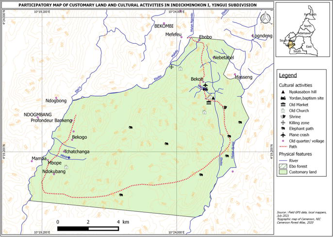
Figure 13.
Cultural activities in Indickminikon I village.
In Figure 10, we found in and customary land of an abandoned village several cultural activities and heritage like the “Halakata sacred forest,” the old Churches, and the old baptism site during the colonial period.
Figure 10 is for the Ndikbanamouan Village where the Chief and the notable reside out of the customary land and are advocating to the government to create and maintain a road to facilitate “their returning back home.”
Figure 11 indicates the spatial distribution of cultural activities type that are of the cultural heritage of the local communities.
The customary land data were also mapped, indicating the understanding and mastering of their socio-cultural belonging. Most of the government land allocations, like the council forest, and forest management unit overlap with their customary land. Since those land allocation reduces communities access to those areas, it also limits their access to their cultural site/ relics for some cultural event. Some of the cultural events, like the local dances, are being disappeared (Figure 14).
Figure 14.
Participatory land use and archeological feature in Ndikolob village.
Communities and related forest dependence cultural activities mapping.
4.5 Contribution of cultural value for sustainable development of rural population in the Ebo landscape
Part of an ongoing memorial crisis [10] in Cameroon, Banen’s mobilizations against the Ebo forest classification depend on the instrumentalization of conscious and unconscious representations. These stem from a series of incidents affecting the project’s neighboring populations in the departments of Nkam, Sanaga Maritime, and Mbam and Inoubou between 1963 and 2017. While re-readings of the 1963 Banen peasant gatherings in urban centers helped to construct the representation of an Ebo “forced exile” following the war of independence, the rejection of a national park project in the forest in 2006 helped to crystallize a Banen identity around this territory.
“Cahier d’un retour au pays natal,” this is the story of a people, the Banens. They left their land in the late 1950s. Historians consider this to be the period of the maquis. Leaving their territory for another where they would find shelter, calm, and security. The destiny of a population then estimated at 10,000 people was turned upside down. But today, hope is reborn. No more maquis. People can go home. And that’s what happened on Saturday, May 13 in Ndogbiakat. “After being evicted during the maquis war, these populations were given access to limited portions of land. Today, we’re fighting to get them back home,” says Samuel Dieudonné Moth, executive chairman of the Forêt d’Ebo development committee.
A large number of people from different backgrounds, including Njombe-Penja, PK30, Bonepoupa from Moufon Indikeboum, Bikong, and Malibot, began the resettlement process.
This is partly due to the actions of the Ebo Forest Development Committee. The committee succeeded in getting a logging company to take charge of tracing around 40 km of road, 30 km of which has already been completed.
“This road represents development. It will enable people who were evicted some sixty years ago to return home. But it must not be an open door to wild sawing or poaching,” explains Che Patrick Ngwashi, Prefect of the Nkam region (Figure 15) [11].
Figure 15.
Banen communities during administrative visit in Lognanga clan https://www.hekok.org/254/cameroun-les-banens-ne-sont-pas-des-sawas.html.
As part of the problem of large-scale land grabbing in Cameroon, the Ebo development conflict allows us to question local development as a political issue, using the tools of local geopolitics [12]. This geopolitical approach makes it possible to place at the heart of this local conflict, the crisis of the idea of the general interest [13, 14]: it corresponds to the loss of the state monopoly in the management of forest massifs to the benefit of a complex and dynamic system of actors in a forest decentralization. We will analyze the mobilization of local populations against the forestry project, with a view to preserving traditional land rights in the name of local development.
The legalization of the “MUNEN-Retour aux sources” association under receipt n°187/2020/RDA/C19/SAAJP, took place in Douala on May 26, 2020 [15]. It resulted from the plural dynamics within the “Les Banen disent NON” collective during the rejected development conflict over the park project. A series of constraints in the Banen collective action against the classification of the Ebo forest lands contributed to the substitution of a platform logic by another associative logic from April 2020.
The development of conflicts in the Ebo landscape reveals the failure of participatory mechanisms experimented by development agencies in support of national bodies and NGOs from various backgrounds [16] in Cameroon.
Issues related to cultural heritage using indigenous knowledge play a vital role in recognizing and mapping the historical range of cultural values that belong to a particular group. The loss of cultural heritage can lead to a sense of disconnection and displacement. It is crucial to recognize and respect the cultural identity of these populations and ensure that their heritage is preserved and valued during the resettlement process. The people, in about 48 villages, of the Ebo forest population who, since a decade have been out of their ancestral land wish to regain their land. The land has a lot of resources which has left the government for its allocation and classification as a state forest. The population wanted the classification to respect their sociocultural heritage within the landscape. The participatory mapping done within this paper is a tool that helps to understand communities’ customary land, their local governance initiative, and problem trees for advocacy.
A lot of movement for advocacy using the communities’ participatory tools has helped the government to understand the way of integrating local communities into the management of their cultural heritage through workshop exchanges and local administration visit to inquire more about their need. It is now recognized that the population needs to return to their ancestral land and need their cultural features to cave from any land occupation.
Thanks to the WRI with Global Forest Watch (GFW) Small Grant project that enables engaging communities in sustainable management of biodiversity in the Yabassi KBA. Thanks to the Biopama project and the Ebo Forest Research Project collaboration, which has added additional data on spatial land-use planning for the achievement of this paper. Thanks to the Forestry authority from Nkam and Mungo Division for their participation in the scope of enhancing monitoring of deforestation alert. And thanks to the communities around the Ebo Forest landscape to have participated in data collection for the elaboration of this chapter.
References
1.Rainbaw EnvironmentalConsult. Méthodologie unifiée de cartographie participative au Cameroun. 2016. p. 74
2.Abbott J et al. Participatory GIS: Opportunity or oxymoro. Participatory Learning and Action Notes. 1998:27-34
3.Beatty MT, Peterson GW, Swindale LD, editors. Planning the uses and management of land. Agronomy. 1978;21:1028
4.Gueye B, Schoonmaker FK. Introduction à la méthode accélérée de recherche participative: rapid rural appraisal, quelques notes pour appuyer une formation pratique. Londres: IITD; 1991
5.Hirt I. Mapping dreams/dreaming maps: Bridging indigenous and Western geographical knowledge. Cartographica: The International Journal for Geographic Information and Geovisualization. 2012;2012:105-120
6.Michael Stone. Map or be mapped. 2012
7.Atlas forestier du Cameroun. World Resources Institutes. 2017
8.Juscar N. La cartographie participative, un outil de Dialogue et de résolution des conflits dans les villages de Nguti. Yaounde: University of Yaounde I; 2020
9.Cameroun:présentation du peuple Banen. Available from: https://www.hekok.org/301/cameroun-presentation-du-peuple-banen.html [Accessed: July 01, 2023]
10.Sigankwé T. Mémoire nationaliste versus mémoire colonialiste, Réflexion sur un paradoxe camerounais, in Socio-anthropologie. 2018. p. 37
11.Cameroun: le peuple Banen de retour sur ses terres. Available from: https://camerounactu.com/cameroun-le-peuple-banen-de-retour-sur-ses-terres/ [Accessed: May 08, 2023]
12.De Sardan. De la corruption aux normes pratiques. Une socio-anthropologie des écarts. Karthala, Holtedahl L, Issa Djesa R. 2017
13.Peter M. Conflits de Droits et Cartographie Communautaire au Cameroun. World Agroforestry Centre et Rights and Resources Initiative; 2009
14.Logo B et al. Governance of protected areas in Central Africa: An evolving process. In: State of Protected Areas in Central Africa – 2020. 2014, 2021. pp. 62-97
15.MINFOF. Article 18 du décret 1995/531 fixant les modalités d’application du régime des forêts. 2016. Available from: http://www.minfof-psfe.com/ressources/doc9_doc473.pdf
16.Nguiffo S. La perception de la forêt et conflits au Sud Cameroun. In: The Congo Bassin-Human and Natural Ressources. IUCN; 1998. p. 85
Written By
Ndjounguep Juscar
Submitted: 04 September 2023Reviewed: 11 September 2023Published: 15 January 2024
 Open access peer-reviewed chapter